| In this section:
|
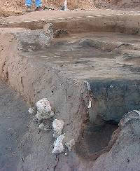
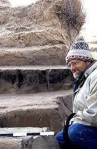
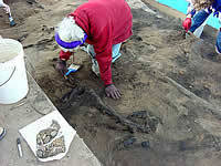
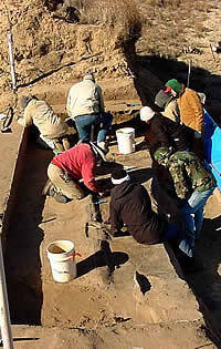
The investigation of Hank's site
was an entirely volunteer effort involving professional
and avocational archeologists. Many people—including
members of the Panhandle Archeological Society and Texas
Archeological Society—joined in the effort. In
this picture, the excavators are just beginning to see
burned clay daub and charcoal. Photo by Doug Boyd.
|
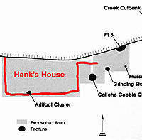
Map of excavations at Hank's site
showing the location of the pithouse and other features.
Click on image to see full map. Graphic by Sandy Hannum,
courtesy Prewitt and Associates, Inc.
|
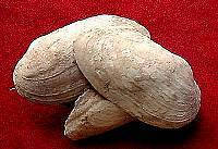
A cluster of stacked mussel shells
was found in the trash midden and work area in front
of Hank's house. The entire cluster was removed intact.
Photo by Doug Boyd.
|
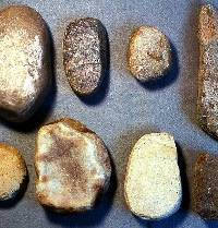
These eight rocks were found in a
tool cache outside Hank's house. Photo by Doug Boyd.
Click to see enlarged view and detailed caption.
|
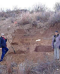
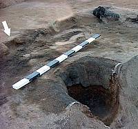
TAS members Reba and Mitch Jones
excavated Pits 1 and 2 located about 15 m away from
Hank's house. The white arrow points to Pit 1, the more
obvious of the two pits in this photo. Photo by Doug
Boyd.
|
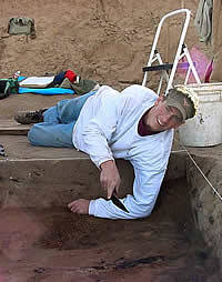
Doug Wilkens (in foreground) looks
up from exposing the tops of the charred posts along
the west wall of Hank's house. And don't let the sunny
conditions mislead you, it was cold! Photo by Doug Boyd.
|
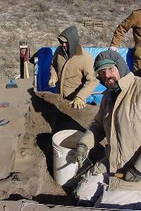
They always say "good help is
hard to find." Here, Mark Erickson is lying down
on the job. Photo by Doug Boyd.
|
| |
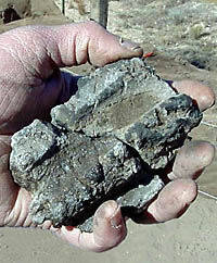
Many pieces of burned daub were found
in the layer of burned debris lying on the floor of
Hank's house. This fragment of daub has parallel stick
impressions that came from small branches used to form
one layer of the roof. Photo by Doug Boyd. |
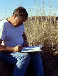
Archeologist Reg Wiseman, from Santa
Fe, New Mexico, writes notes sitting next to a clump
of Sorghastrum nutans. This is the yellow Indian
grass that was used in the construction of the roof
of Hank's house. Photo by Doug Boyd.
|
Looking eastward across the exposed
floor of Hank's house, the depressed interior channel
and entrance step are clearly visible. Remnants of clay
wall plaster are visible along the south edge of the
entrance and along the front (east) wall of the house.
Photo by Doug Boyd.
|
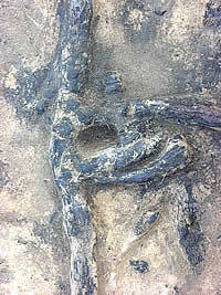
Close-up view of the burned posts
and clay plaster along the back (west) wall of Hank's
house. When the posts were excavated, 20- to 40-cm-deep
post holes were found and it was clear that the back
wall leaned slightly inward—about 14 degrees off
of vertical—toward the inside of the house. Photo
by Doug Boyd.
|
John Erickson examining the exposed
charred posts of Hank's house with a bemused look on
his face. By this time, the layout of the house was
becoming clear. Photo by Doug Boyd.
|
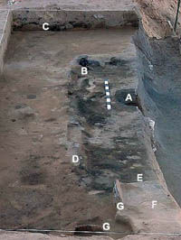
Central hearth or firepit in Hank's
house before it was excavated. The layers are: (A) upper
fill, post-occupation deposits; (B) layer of burned
branches and clay daub from roof fall; (C) blow sand
inside hearth; (D) ash layer at bottom of hearth; (E)
baked clay lining of the hearth; (F) pre-house sandy
soil into which the house was dug; and (G) caliche
rocks that are part of a natural layer of intermittent
gravel in the alluvial terrace (i.e., representing a
flood event before the house existed). Photo by Doug
Boyd.
|
An arc-shaped notch in the southern
channel lip indicates where an extra post had been placed.
The notch was cut out of the channel lip, but the post
rested directly on the floor. This may represent a repair
post that was put in to help support a sagging roof,
and it suggests that the house had been lived in for
some time. Photo by Doug Boyd.
|
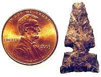
This small triangular arrow point
is called a Washita, a style that is common among many
Southern Plains Village groups in the Texas Panhandle
and western Oklahoma. This artifact was found along
the back wall of Hank’s house. It is discolored
and fractured by intensive heating, and it was definitely
inside the house when it burned. Photo by Doug Boyd.
|
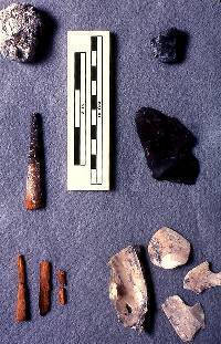
The cluster of artifacts found on
the floor of Hank's house against the south wall is
tentatively interpreted as a potter's tool kit. Click for enlarged image and more-detailed caption.
Photo
by Doug Boyd.
|
TAS member Teddy Stickney from Midland,
Texas, carefully exposes the charred branches on the
floor of Hank's house. All of the charred fragments
were collected so that the wood could be identified
later. Sediment from the floor of the house was collected
in bags for flotation to recover tiny pieces of charred
plants. Photo by Doug Boyd.
|
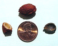
The plum pits found at Hank's house
were lightly charred and were cracked open to remove
the edible seed inside. Wild plums grow in many places
in the West Pasture canyon and would have been an important
food resource. This photo shows a prehistoric plum pit
fragment (right) compared with a whole modern pit (top)
and a cracked modern pit (left) from a nearby plum thicket.
Photo by Doug Boyd.
|
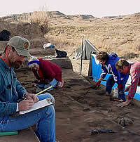
Taking notes and making sketch maps
were an important part of the excavation at Hank's site.
Here, Doug Wilkens is making notes on what he has uncovered.
To the right, Kris Erickson and Reggie Wiseman are exposing
the burned branches and daub that fell when the house
burned. Photo by Doug Boyd.
|
There was no shortage of materials
suitable for dating. Large intact pieces of burned branches
were found on or near the floor in Hank's house. These
materials represent portions of the roof that burned
and collapsed onto the floor. Photo by Doug Boyd.
|
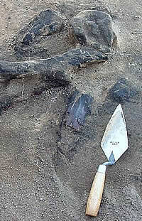
Sample
of charred corn cupules from Hank's house. Cupules are
the cup-shaped sockets in a corn cob that hold the corn
kernals in place. Using the AMS (accelerator mass spectometry)
radiocarbon dating technique, age estimates can be obtained
on even tiny fragments of organic material, such as
a single corn cupule. Photo by Doug Boyd.
|
|
The prospect of investigating Hank's house was
exciting because its well-preserved remains offered an opportunity
to learn a great deal about the architecture of a Plains Village
pithouse. We wanted to "salvage" the information
before the next big flood completed the erosional process
and washed away the remaining half of the house. Such floods
are highly unpredictable—it might be 20 years or 24 hours
before a real Panhandle gully washer stalled over the upper
end of the West Pasture and remodeled the landscape, sending
Hank's house tumbling down the streambed. So we decided to
conduct a salvage excavation as soon as possible. But first
we had to find a crew and solve some logistical problems,
the heaviest of which (literally) was removing the thick mantle
of up to two meters (seven feet) of sand covering the pithouse.
Finding a willing crew proved easy enough once
Doug Wilkens and Doug Boyd spread the word of what we had found. The
Panhandle has a small, but active group of experienced avocational
archeologists, most of whom are members of the Panhandle Archeological
Society and the Texas Archeological Society. We also persuaded
several professional archeologists active in Southern Plains
archeology to take time "off" and join us. Meanwhile,
Erickson took care of the logistics including establishing
a field camp at the site where we could store equipment and
preparing an excavation platform along the creek cutbank.
We returned to the M-Cross Ranch in late November,
2000, with a sizable contingent of volunteers. Before most
arrived, landowner John Erickson used his small bulldozer and Bobcat to remove
the overburden (overlying sand), stopping a foot and a half
(40-50 centimeters) or so above the pithouse layer. Over the
next week, the volunteer crew put in 406 hours of labor as
we exposed most of the remaining half of the pithouse and
several of the associated features. We had hoped to finish
the dig in one session, but couldn't quite do it. In mid-May,
2001, we returned with a smaller crew for a three-day dig
to wrap things up. The rest of this section explains what
we found.
Sliced in Half
Hank's site is formally known as 41RB109, being
the 109th officially recorded site in Roberts County, Texas.
The unnamed creek through the West Pasture had, in essence,
given us the kind of view that archeologists often like to
start with—a long cross-section or slice through Hank's
site. The map on the left shows the area we excavated and
the archeological features we identified along this slice.
Before discussing the prehistoric house proper, let's look
at some of the other features we found outside the house.
Some of these were very close to Hank's house and very likely
"functionally associated," meaning they were probably
created and used by the occupants of the house. But others
are farther away and were probably part of another household—without
additional excavation we can't really tell.
Hank's house faces east, like many Plains Village
houses, and has an extended entranceway (see house diagram
on right). We excavated around the front of the house and
found several noteworthy features. In front of Hank's house
was a trash midden, a thin sheet-like layer of household
trash —scattered bits of artifacts, such as flint flakes
and pottery sherds, mixed with dark, charcoal-stained soil.
Within the midden were three distinct groups of objects (archeologists
call such groupings cultural features), all of which indicate
that the area in front of the house—a sort of "front
porch"—was used not only for discarding trash, but
also served as a storage area and probably a work area.
Caliche Cobble Cluster: The first feature
was a cluster of unmodified caliche rocks that were probably
collected and piled with the intent of being used at a later
time.
Mussel Shell Cluster: The second was
a tightly packed cluster of six complete mussel shell valves
that had been stacked, one inside the other. These, too, appeared
to represent materials that were stockpiled for later use.
Grinding Stone Tool Cache: The third
feature within the trash midden was a tool cache of eight
rocks, seven of which were grinding tools. A "cache"
is a group of objects that were intentionally stored, perhaps
even hidden. A metate, a pestle, and five different sizes
and types of manos were found in a tight cluster and appeared
to have been stored in a small pit. These grinding implements
made up a diversified tool kit useful for a variety of different
functions. The eighth rock was a large chunk of very grainy
and poorly consolidated conglomerate. The large rounded sand
grains that comprise this rock look very similar to the grains
seen in many of the potsherds found on the site. Pieces of
this rock may have been crushed up and added as a tempering
agent to the clay used for making pottery.
Storage Pits: On the edge (as we perceived
it) of the sheet midden was the bell-shaped pit (Pit
3) found just outside the entrance to Hank's house. We found
two other bell-shaped pits 12 to 15 meters east of Hank's
house. Like Hank's house, all three of these pit features
had been sliced in half by erosion. The bell shape of the
pits is typical of underground pits used by many different
prehistoric and historic Indian groups across much of the
Great Plains, and they were typically used by farming peoples
for storing crops that were harvested in the fall for use
later in the winter. The relatively narrow entrance at the
top of the pit was necessary so that the opening could be
easily covered by a large flat rock, a flat piece of wood,
or perhaps a smoked buffalo hide cover held down by rocks
and covered by dirt. The covered pit would have been hidden
and protected from most varmints (at least until some lucky
rat dug his way into it).
Because Pit 3 was located just past the
entryway to Hank's house, it likely served as an underground
storage bin for the people who lived in the house. The pit
could have been used for many years but probably was abandoned
when some food rotted inside it or burrowing rodents dug into
it. Once the pit became useless for food storage, the people
living in the house probably filled it with household trash,
bits and pieces of which we found.
Because Pits 1 and 2 were located some distance
from Hank's house, they were probably not associated with
Hank's house and may have been used by people who lived in
another residential structure nearby. Like Pit 3, Pit 2 was
filled with cultural debris (trash) and had been converted
from a storage pit to a trash pit. In contrast, the fill inside
Pit 1 contained no cultural debris, the sediment fill inside
was very clean (there was no charcoal or ashy sediment), and
the pit outline was well defined. This may indicate that the
last function of the pit was for storage of perishable foods.
An attempt was made to identify any organic remains that might
have been stored in this pit, but none were preserved.
Architecture of Hank's House
In this section, we take a closer look at what
we found in the pithouse and what we think it means. Excavation
is a process of discovering evidence, but detailed and accurate
records must be kept so that you can study and interpret that
evidence after it is dug up. Each layer of fill in Hank's
house was carefully excavated and all artifacts and features
were plotted on excavation maps. Descriptions of the excavations
and features were written, and hundreds of forms and maps
were created. Thousands of photographs (black and white, color
slides, and digital images) were taken to document every detail
the archeologists saw. All of the artifacts were collected
in bags marked with precise location information (provenience),
and many charcoal and soil samples were taken. All of these
steps are time consuming but important because what remained
of Hank's house was destroyed in the act of excavating it.
A site cannot be reconstructed to reveal the stories of life
long ago unless such detailed records are kept and studied.
The process is similar to how forensic scientists investigate
a crime scene to learn exactly what happened.
During the excavation, we separated the sediment
inside the house into three stratigraphic layers called the
upper fill zone, middle fill zone, and floor zone. The upper
fill zone represents sediment and artifacts that were
deposited inside the depression created after the house was
abandoned and collapsed. The sediment was mainly eolian sands
that were blown in by the wind, and the artifacts were probably
thrown into the shallow depression by prehistoric people.
We suspect that the depression filled in quickly, probably
within a few years of when the house fell down.
The middle fill zone was marked by the
appearance of charcoal staining and small fragments of burned
clay daub, and these burned materials became larger and denser
throughout this zone. Large intact pieces of charred wood
and burned daub found in this zone clearly indicated the house
had burned. These materials were especially abundant in the
western portion of the house, where the burning was quite
intensive, but sparse in the east side and southeastern corner.
It soon became clear that the debris represented the materials
from the roof of the house that had burned and collapsed.
Some of the burned wood represented long segments of tree
branches, while many of the burned daub fragments had parallel
stick impressions indicating that wet clay had been pressed
onto the inside of the roof. The burned daub was most abundant
in the center of the house, indicating that lots of clay was
used to line the smoke hole above the central fire pit. The
people who lived in Hank's house must have been concerned
about the possibility of sparks from the fire pit rising and
igniting the roof.
The floor zone represents materials found
in the last 4 to 6 inches above the floor of the house. This
zone contained abundant charred wood and burned daub, mainly
in the western area, and some artifacts. Where the burning
was intensive, the floor itself was a thin layer of baked
clay sediment, and the excavators could easily follow the
floor. In this area, small hollow tubes of charred grass found
lying directly on the floor had once been part of the roof.
In the eastern part of the house where little or no evidence
of burning was observed, the floor was difficult to follow.
The unburned clay on the floor had gradually melted away (dissolved)
as water percolated down through the sandy sediments over
many hundreds of years.
When the excavations ended, we had exposed exactly
one half of the original pithouse and the house layout was
obvious and familiar. Hank's house was similar in many ways
to other pithouses found and excavated in the Texas Panhandle,
but it also was unique in many respects. The burning of the
structure preserved many important architectural details.
Some are typical of prehistoric pithouses of the Antelope
Creek and Buried City cultures, others are not. Each of the
key architectural features of Hank's house is described below.
Clay-plastered Entryway: Hank's house
had a nine-foot-long entryway that was plastered with clay.
It began about three feet inside the east wall of the house
and extended eastward six feet beyond the east wall. It was
essentially a paved ramp that sloped from the original ground
surface at its east end down into the house, and the walls
of the entrance extended into the house at least two feet.
The ramp bottomed out just inside the house, but rose sharply
on its west end forming a hump or step that was several inches
higher than the floor or the lower edge of the entry ramp.
This was obviously a high-traffic area, and multiple layers
of clay indicated that the step had been replastered several
times. It also formed a depression in the entryway where the
bottom of the ramp met the step. Fine, laminated layers of
sediment in this depression suggest that it was a water trap
that prevented water from running into the house during heavy
rains.
West Wall: The west wall of the house
was the best-preserved architectural feature because it had
been intensively burned. Along the west wall, eight wooden
posts had been completely charred and clay wall plaster between
them was burned and still in place. Below the floor level
there were six post holes, round to oval in shape, found beneath
charred posts. The two burned posts that did not have corresponding
postholes were resting directly on the floor and had not been
set into the ground. The posts ranged in size from 3 to 4
inches (7 to 11 cm) in diameter, and from 8 to 16 inches (20
to 40 cm) in depth below the floor. In cross-section, some
charred posts were round and had been complete logs or branches,
while others were arc-shaped (half branches) or thin slats
that represent split branches. It is quite possible that wood
was scarce enough that the builders split some branches to
conserve their lumber. The west wall plaster and charred posts
were preserved to a height of about 2 feet above the house
floor. Most of the posts were burned down only to the floor
level, where the fire probably stopped due to lack of oxygen,
but a few posts were charred down below the floor level and
deep into the postholes. Such burning is not common, but modern
ranchers have seen wooden fence posts burn down deep into
the ground in some cases.
South wall: Eight post holes were found
along the south wall, but only one remnant of a charred post.
The post closest to the southwest corner of the house had
been burned in place, but only a small portion of it was found
above the floor level. It appears that the intensity of the
fire was greatest in this corner, but the burned debris found
on the floor diminished toward the east. Three large flat
chunks of burned clay were found along the south wall near
the southwest corner of the house. These appear to have been
remnants of clay plaster from the wall, and two of the pieces
appeared to be in place along the south wall. The post holes
along the south wall ranged from 7.5 to 17 inches (9 cm to
43 cm) deep below the floor level. Based on the diameters
of these postholes, the posts were probably about the same
sizes as those on the west wall—about 3 to 4 inches
(7 to 11 cm) in diameter.
East wall: The east wall was marked by
five post holes but no charred posts were found. Remnants
of wall plaster were found adjacent to and near the entryway
step. The absence of burned posts and scarcity of burned wall
plaster indicates that the fire was not very intense toward
the front of the house. The east wall post holes ranged from
7 to 12 inches (18 to 31 cm) deep below the floor level. These
posts were probably about the same sizes as those along the
west wall.
SW Central Post: This was a very large
post, set deeply in the ground. This post was very obvious
to the excavators because a large chunk of a burned log, measuring
nearly 6 inches (15 cm) in diameter, was preserved and stuck
up several inches above the floor level. This large post had
burned in place, but the burning stopped just below the floor
level. When a deep test was excavated through the floor to
reveal the profile, the post hole was 10 inches (25 cm) wide
at the top and tapered to a point at a depth of about 24 inches
(60 cm) below the floor level. The tip of the post had been
charred before it was set into the ground.
SE Central Post: We almost didn't find
this posthole—a fact that serves as a cautionary note
to archeologists digging pithouses like Hank's. As we excavated
Hank's house, it seemed to be following a pattern of interior
features that was similar to that of other pithouses in the
Antelope Creek area. Once the southwest central post was found,
it seemed logical that there must be a corresponding southeast
central post. But when we reached the floor level at this
location, the expected burned post or a posthole wasn't there.
Instead, it seemed to be a continuous floor surface. Some
burned debris was across the floor in this area, and there
were lots of rodent burrows, but there was still no hint of
this post hole as we troweled through the floor. We joked
that it was obvious the Indians must not have read an archeological
report on how their house should have been built.
Puzzled, we kept on digging below the floor
with our trowels because we were convinced that there had
to be a southeast central post to support the roof. It was
not until we had dug a full 4 inches below what appeared to
be an intact floor surface that the first hint of a post hole
was seen. At this point, we found a circular stain that measured
about 9 inches (23 cm) in diameter. We then dug a small pit
down below the floor to create a profile and found that the
posthole extended down 20 inches (50 cm) below the floor level.
Like the southwest central post, the tip of the southeast
central post had been charred before it was set into the posthole.
Central Firepit: In the very center of
Hank's house was the firepit or central hearth. The hearth
was created by digging a large, bowl-shaped pit and lining
it with clay plaster. When viewed from above, the hearth appeared
as a circular pit ringed by a ridge of clay that was about
5 cm higher than the surrounding floor. The outside diameter
of the clay ridge was 20 inches (50 cm), and its inside diameter,
the mouth of the pit, was 18 inches (45 cm). When viewed in
profile, the hearth had a deep bowl shape and tapered to a
rounded bottom that measured about 11 inches (28 cm) in diameter.
The pit was 11.5 inches (29 cm deep).
Several layers of fill were evident in the firepit.
The layer of burned debris across the floor of Hank's house
extended down about 4 inches (10 cm) into the hearth pit.
This represented roof fall material from when the house burned.
Below that was a layer of brown clayey sand, 4 to 5.5 inches
(10 to 14 cm) thick, that looked like wind-blown sand. On
the very bottom was a 4- to 5-inch (10 to 13 cm) thick layer
of gray ash, presumably from the last time the hearth was
used. At the top of this ash layer, a single sherd of cordmarked
pottery was found.
The clay layers that lined the hearth were interesting.
There was some hint of lamination, suggesting that several
layers of clay might have been added at different times. There
also was an outer layer of clay that was definitely added
at a later time. Several inches of clay had been mounded up
to reform the rim of the hearth, and this added layer extended
about half way down inside the hearth before abruptly ending.
Central Channel: Hank's house had a distinctive
depressed floor area in its center. If the house were complete,
it would have formed a rectangle with a central roof support
post at each corner. Often called a central channel, the rectangular
area around the hearth was about 4 inches (10 cm) lower than
the surrounding floor. Such depressed floor areas are common
features in many Antelope Creek houses, but its precise function
is not known. Archeologists have speculated that it may have
helped with airflow around the central hearth, and it might
have served as a water trap to keep most of the house dry
if water seeped (or poured) inside during heavy rains. The
central channel also served as the main kitchen and living
room, around which people would do many different activities.
The area around the channel would have been used for storage
of belongings and sleeping areas.
Post Notch: An arc-shaped notch was found
along the southern channel lip, about half way between the
southwest and southeast central posts. This notch appears
to have been added sometime after the house was initially
built, presumably to accommodate the bottom of a vertical post.
It may mean that the house was used for several years, at
least long enough for the roof to begin sagging and require
an additional support post.
Artifacts
The artifacts recovered from Hank's site can
be classified into six groups based on how they were associated
with the house:
Post-Occupation Fill: artifacts found
in the upper levels of sediment inside the pithouse. These
materials probably represent trash from occupations of other
houses nearby that was thrown into the pithouse depression
after Hank's house was abandoned.
House Refuse: artifacts found in the
sheet midden in front of the entrance to the house. These
materials were probably used and discarded by people who lived
in Hank's house.
House Storage: artifacts associated with
the three storage/cache features found in the midden area.
House: artifacts found on or near the
floor of Hank's house. These materials represent items used
by the inhabitants of the house.
Pit 3: artifacts found inside Pit 3.
These materials were probably used and discarded by people
who lived in Hank's House.
Pit 2: artifacts found inside Pit 2.
These materials were probably used and discarded by people
who lived in a separate house nearby.
Several of us involved in the dig along with
some outside specialists are still studying the artifacts
and samples from Hank's site. Proper analysis takes time and
isn't considered complete until a final technical report is
prepared. Since this is a volunteer effort, we work on it
as we can and keep chipping away at it, bit by bit. Some of
the artifacts in the house assemblage are important for understanding
the people who lived in Hank's house and are mentioned here.
The house assemblage is really very small, and
it was obvious which artifacts had been in the house when
it burned. A few flakes of Alibates flint, some turtle bones,
and some fragments of cordmarked pottery were found directly
on the house floor. A Washita arrow point was found in a mass
of burned debris along the west wall. It is also made of Alibates
flint but is permanently discolored due to the intensive heating.
Because its tip was broken off, it seems likely that someone
had brought an arrow home to take off the broken point and
lash on a new one. The broken point was probably discarded
or lost in the house.
One feature found on the floor of Hank's house
is a cluster of artifacts found along the south wall. This
group of artifacts consists of two bone tools, a mussel shell
scraper, a rounded caliche pebble, a rounded silicate pebble,
and a flake with a worn edge. All of these tools were found
in a small pile, as if they had been intentionally laid there
or perhaps inside a rawhide bag or small basket (which subsequently
rotted). Although we can't say for sure what these artifacts
represent, my working hypothesis is that they represent a
"potter's tool kit." Such tool kits were groups
of implements that would have been used to make pottery.
The pottery we've found at Hank's site doesn't
match the thin Borger
cordmarked pottery found in Antelope Creek sites. Most
of it is relatively thick-walled and is tempered with chunks
of scoria, a locally available volcanic rock. Scoria tempering
has not been reported from most Plains Village sites, and
was once regarded as a diagnostic trait of Woodland-period
pottery. We're finding scoria-tempered pottery all over the
West Pasture, and its presence in this area makes perfect
sense because large chunks of scoria are found in the upland
gravels along much of the Canadian River valley in the eastern
Texas Panhandle.
The local scoria is a dark red to black, porous-looking
igneous rock full of little air pockets that form tiny holes
along its edges. It is, in fact, a volcanic slag ejected out
of a volcano during an eruption. The most important characteristics
of the local scoria are that the weathered nodules are easy
to crush up, and the tiny bits of rock have sharp angular
edges and make excellent temper for binding clay together
in pottery making.
In the West Pasture sites, scoria-tempered cordmarked
pottery is found in contexts that are definitely Plains Village,
such as on the floor of Hank's house and in the trash-filled
storage pit nearby. Jack Hughes reported finding it at a number
of Plains Villager sites in the eastern Panhandle. David Hughes
also noted scoria tempering in some of the ceramics at Buried
City. Thus it appears to be a common pattern in the eastern
Texas Panhandle and a continuation of a more widespread Woodland
pattern.
Special Samples
Besides the artifacts recovered from Hank's
site, many samples of charred materials and sediment (from
soil or fill layers) were collected. Sediment samples were
processed using the flotation method to recover charred plant
remains. All of these samples were then examined by Dr. Phil
Dering, then with the Archeobotany Laboratory at Texas A&M
University (Dering now has his own independent lab in Comstock,
Texas). Many of the charred samples were of wood or grass
that was part of the house and are discussed below. Other
charred samples from the floor of the house, the storage pits,
or the trash midden in front of the house represent plant
foods eaten by the people who lived there. Several charred
fragments were identified as corn (Zea may) and indicate
that the inhabitants were farmers. Corn has been found in
the village sites of the Antelope Creek and Buried City peoples,
but this is the first time corn has been found in a village
in the eastern half of the Canadian River valley. Corn remains
were found on the floor of Hank's house and in the trash-filled
storage features (Pits 2 and 3).
Besides the corn, lots of fragments of charred
sunflowers seeds were found on the house floor and in the
central hearth. Because the seeds were all very small, we
know that these were from wild sunflowers rather than the
larger domesticated varieties. Plum pits also were found,
particularly in the trash midden area in front of Hank's house.
It was difficult to determine whether they were unburned or
burned, but a few appear to have been roasted lightly, with
the pits having been broken open to get at the tiny seed inside.
Another interesting find in Hank's house was
a burned clay mud-dauber's nest. This nest was built by flying
wasps, probably the black and yellow mud-dauber (Sceliphron
caementarium). Using mud from the creeks, they create
organ-pipe nests composed of multiple tube-shaped cells. The
wasps lay an egg inside each cell, and they add a collection
of tiny spiders, still living but paralyzed by venom. When
the egg hatches, the wasp larvae feeds on the spiders until
it matures and breaks out of the cell. Mud-daubers commonly
build their nests in protected areas, such as underneath the
overhanging eaves of houses or barns. Because mud-daubers
have two generations of offspring a year—one in the winter
and one in the summer—the nests found in prehistoric
sites are not good indicators of the seasons when occupations
occurred. The mud-dauber nest found at Hank's house has one
sealed tube and one open tube, but it is not uncommon for
larvae to never mature and emerge, and mud-dauber nests may
survive intact for several years unless people remove them.
These mud-daubers are not particularly aggressive, but people
at Hank's site would have viewed them as pests because their
stings are rather painful. Mud-dauber nests are very common
in abandoned houses, and the burned nest found inside Hank's
house would have come from the inside. Although it is not
conclusive, this could be evidence that the house had been
abandoned for at least a few months in the winter or summer
before it burned.
Dating: When was Hank's House Built?
Three radiocarbon dates provide the best
evidence of when Hank's house was built. The first date was
obtained from a large chunk of charred wood taken during the
initial site investigation. This sample represented wood from
the roof of the house that burned and collapsed onto the floor,
but we believe the date on this sample is too old because
of the old wood problem. To illustrate the old wood
problem, bear in mind that the radiocarbon dating method measures
the time elapsed since an organism, a tree in this case, died
rather than the time elapsed since the burning episode. This
is because living organisms continue to "cycle"
atmospheric carbon and accumulate tiny fractions of radioactive
carbon-14 (C14). Once they die, the accumulated C14 slowly
decays, or breaks down, from its radioactive form into nitrogen-N14.
By measuring the ratio of C14 to stable carbon isotopes C12 and C13,
we can estimate the elapsed time since the organism died.
Since the first sample from Hank's was only
a section of a burned branch, it may have been from the core
of the branch rather than the outer rings. Since the interior
core wood of a tree branch is dead while the outer rings are
living, a date on core wood could be much older than the actual
time the tree died. Unfortunately, there is often no way to
evaluate this. It also is possible that the sample represents
old wood that was used long after the tree had died. If a
branch that had been dead for many years was used in the construction
of the roof of the house, a radiocarbon date from it would
be much older than the actual time when the house was built
and used. Keep in mind that in circumstances where wood is
scarce, like the Texas Panhandle, prehistoric peoples often
reused the timbers of old houses to build new houses. Such
recycled timbers protected inside a house could be tens or
even hundreds of years old. It is not uncommon to encounter
situations where a radiocarbon date representing the death
of a tree is many years older than—even a century or
two before—the actual event that an archeologist is trying
to date.
When we got back the first date in the fall
of 2000, we had no reason to doubt it, but we knew from experience
that it is risky to rely on a single radiocarbon date. Radiocarbon
dating is a statistical estimation technique and any statistician
knows that the larger your sample size, the more confident
of the estimate you can be. In our case, "large sample
size" meant getting more than one date, and that is exactly
what we did. So two more dates were run; this time we were
careful to minimize the risk of the old wood problem.
The other dates are better indicators of the
true age of Hank's house. The second date was from the
outer rings of the large juniper post found in the house.
While the 8-inch-diameter post is composed of many tree rings,
only the outermost ring was living at the time the tree was
cut. By selecting a sample of only the outer two or three
rings, the radiocarbon date will represent the last two or
three years of the tree's life. The third date was on charred
corn cupule fragments recovered from the floor of Hank's
house. Since corn plants only live for one year, the radiocarbon
date on this sample represents the year the corn cob was harvested.
It is likely that the corn cupule was burned when the discarded
corn cob was used as fuel and trampled into the floor the
same year that the plant was harvested. The corn fragment
was trampled into the floor where it lay for about 700 years
until archeologists dug it up.
|
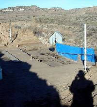
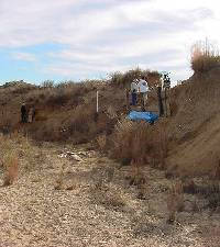
View looking to the northwest at
the start of the excavations at Hank's house showing
the setting in the West Pasture valley.
Click images to enlarge
|
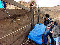
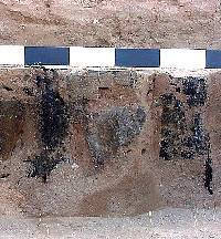
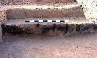
The layer of burned debris was exposed
all along the cutbank edge just above the floor of Hank's
house. In order to make the work easier, a frame of
vertical posts and horizontal 2 x 6 inch boards was constructed
to create a work platform along the cutbank. Photo by
Doug Boyd. |
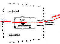
Diagram showing excavated and projected
house outline and features. Red line shows cutbank.
Graphic by Sandy Hannum, courtesy Prewitt and Associates,
Inc. |
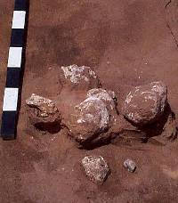
A cluster of large caliche cobbles
found in front of Hank's house. Photo by Doug Boyd.
|
| |
This photo shows three of the eight
rocks in the grinding stone tool cache found in front
of Hank's house. All eight specimens appeared to have
been placed inside a small pit. Photo by Doug Boyd. |
Reba (in back) and Mitch Jones excavating
the surviving half of Pit 3, found just outside the
entrance to Hank's House. This had once been a bell-shaped
storage pit but it had been backfilled with trash—probably
by the people who lived in Hank's house. Photo by Doug
Boyd. |
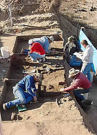
Archeologists excavating Hank's house
in November, 2000. Photo by Doug Boyd. |
| |
Some of the charred branches found
on the floor area were at right angles, as if they were
still lashed together when the roof burned and collapsed.
Photo by Doug Boyd. |
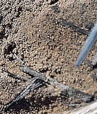
As the excavations reached the floor
level, archeologists spotted small hollow tubes of burned
grass and took lots of samples. They looked like the
yellow Indian grass (Sorghastrum nutans) that
grows on the site today, and this identification was
later confirmed. Photo by Doug Boyd. |
Plan map showing the excavated half
of Hank's house and all of the architectural features
that were found. Click to see larger version with an
inset drawing of the projected reconstruction of what
the entire plan would have looked like. Graphic by Sandy
Hannum, courtesy Prewitt and Associates, Inc. |
The wooden posts along the back (west)
wall of Hank's house were burned in place, and the layer
of clay plaster between the posts was well preserved.
The posts were spaced rather evenly, each being about
15 to 25 cm apart. The floor of the house is visible
in the foreground. Photo by Doug Boyd. |
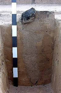
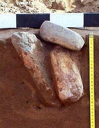
A large chunk of the southwestern
central post was burned at the floor level and was identified
as juniper wood. Below the floor, the posthole could
be traced downward 60 centimeters (24 inches). At the
bottom of the posthole, the tip of the post was pointed
and outlined with charcoal. This shows that the people
who build Hank's house intentionally burned the tip
before setting it into the ground to deter the wood
from rotting and insects from feeding on it. Photo by
Doug Boyd. |
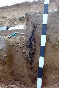
This wall post (just to the left
of the striped photo stick) burned into the ground,
but the charring did not continue all the way. The pointed
soil discoloration below the charred section shows the
shape and extent of the original sharpened post. Photo
by Doug Boyd. |
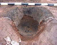
After being completely cleaned out,
the deep-bowl shape of the firepit (central hearth)
is obvious. The hearth had been lined with clay originally,
but a second layer of burned clay plaster had been added
at some later time, probably to repair the firepit as
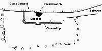
it wore down. Photo by Doug Boyd. |
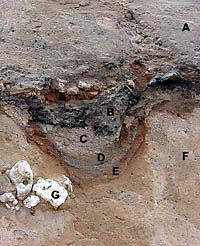
Overview of the exposed architectural
features inside Hank's house. The excavation is down
to the floor over much of the house. Interior features
are: (A) central hearth; (B) charred log of southwestern
central post; (C) charred posts and plaster along the
back (west) wall; (D) location of the southeastern central
post (it had not been found at the time photo was taken);
(E) entryway step; (F) entrance ramp; and (G) remnants
of clay plaster along the entryway and front walls.
The 1-meter-long photo scale is lying inside the depressed
central channel. Photo by Doug Boyd. |
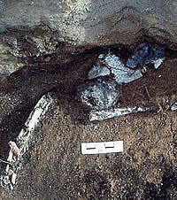
This group of artifacts was found
lying on the floor along the south wall of Hank's house.
They were badly burned during the house fire. These
artifacts—two elongated bone tools, a mussel shell
scraper, a rounded caliche pebble, a rounded silicate
pebble, and a flake with worn edge—might have been
inside a small bag or basket that burned completely.
Photo by Doug Boyd. |
This photo shows all of the artifacts
that were found in Pit 3, the bell-shaped storage pit
just outside the entrance to Hank's house. These artifacts
were discarded as trash into the pit, probably by the
people who lived in the house. The items, which include
seven flakes, two bone fragments, and a pottery sherd,
represent typical household trash. Photo by Doug Boyd. |
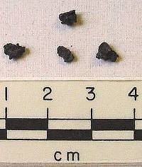
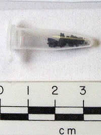
Small charred fragments of corn "cupules,"
the cup-shaped pieces of cobs that seat the corn kernals.
All corn fragments were recovered by the flotation method,
a technique of taking soil samples and bathing them
in bubbly water so that all of the charred plant remains
float to the top. This technique is used to recover
fragile materials that are often destroyed by sifting
soils through metal screens. Photo by Doug Boyd. |
| FAQ:
What is Flotation?
Flotation is a recovery technique that
archeologists and specialists use to separate.... read
more>> |
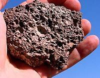
Scoria, a locally available volcanic
rock, was used for pottery temper by the villagers who
lived at Hank's site. The local scoria is a dark red
to black, porous-looking rock full of little air pockets
that form tiny holes along its edges. It is, in fact,
slag ejected out of a volcano during an eruption. The
most important characteristics of the local scoria are
that the weathered nodules are easy to crush up, and
the tiny bits of rock have sharp angular edges and make
excellent temper for binding clay together in pottery
making. Photo by Doug Boyd.
|
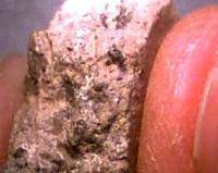
Scoria fragments are apparent in
the broken edge of this cordmarked pottery sherd from
Hank's site. Photo by Doug Boyd.
|
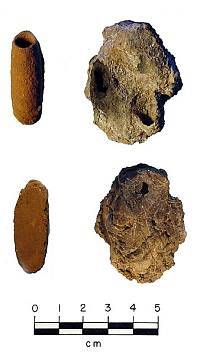
Comparison of burned mud dauber
nest (right) found on the floor of Hank's House with
a modern example (left). Mud daubers, a type of wasp,
build their nests by collecting wet mud and shaping
it into cylindrical tubes, or cells, within which eggs
are sealed. The modern example is a single cell, but
the 700-year-old nest found in Hank's house contained
four cells, one of which is complete and still sealed.
The nest survived because the mud was baked when the
house burned. Photos by Doug Boyd.
The top row shows the "front" view of the
nests, while the bottom row shows the back of the nests.
On the back side of every mud dauber nest is an impression
of the material to which it was attached. In the lower
left, the modern nest is flat because it was attached
to a piece of cut lumber. In contrast, the back of the
nest from Hank's house (lower right) has impressions
of grass and sticks, suggesting that it was probably
attached to the underside of the roof of the house.
|
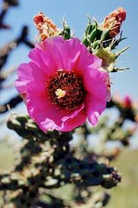
This flowering cholla, like all living
organisms, continuously "cycles" atmospheric
carbon, including tiny fractions of radioactive carbon-14
(C14). Once an organism dies, the accumulated C14 slowly
decays (breaks down) into the stable form, C12. Since
the decay rate is known (C14 has a half-life of 5,730
years), the ratio of C14 to C12 in a sample of dead
organic material, such as charred wood, allows the calculation
of a statistical estimate of the elapsed time since
death. Photo by Kris Erickson. |
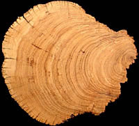
This section of half a juniper tree
illustrates the "old wood" problem nicely.
During its life, the tree had developed two lobes and
had split naturally near its center. The wood making
up the outer rings (far left) is decades younger than
the old, heart wood at the center (far right). Photo
by Rolla Shaller, courtesy Panhandle-Plains Historical
Museum. |
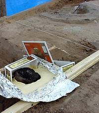
The charred portion of the southwestern
central post was jacketed in dental plaster so that
it could be safely removed from the ground. Portions
of the outer rings of the log were removed in the lab
and used for radiocarbon dating to determine when the
juniper tree was cut down. Photo by Doug Boyd. |
|