Texas Beyond History
TBH Home
Frontier Forts Main

The Post on Government Hill

Ft. Griffin
The afterglow of a setting winter sun backlights the ruins of the administraton building at Fort Griffin. The post was moved to a plateau above the Clear Fork of the Brazos River after an early site on the "flat" below proved susceptible to flooding. Photo, TARL Archives.
Clear Fork
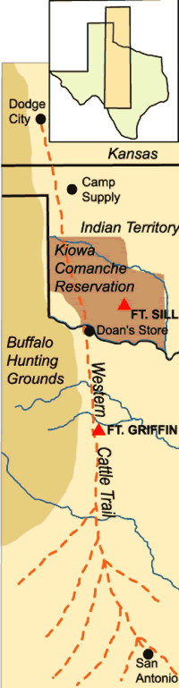
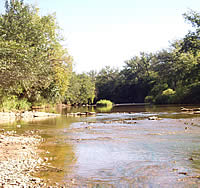
The Clear Fork of the Brazos. Travelers between Fort Griffin and Fort Richardson crossed this wide, shallow stretch of the river below the town called, "The Flat." Photo by Susan Dial.

Click images to enlarge  

sketch of Ft. Griffin
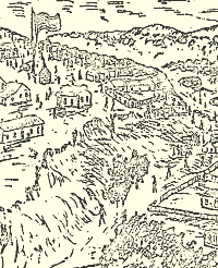
Sketch of Fort Griffin overlooking the town known as The Flat below. Sketch circa 1876, courtesy Texas Parks and Wildlife: Harlan, 1969.
bakery
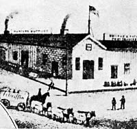
The post bakery at Fort Griffin after renovation. Because bread was one of the staples of the soldiers' mess, hundreds of loaves of bread per week were produced in the bakery's brick ovens. Photo by Susan Dial.
Masonic Lodge in The Flat
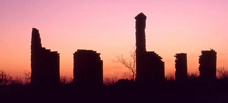
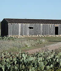
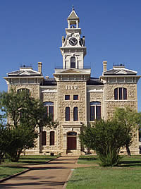
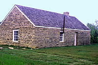
The last standing reminder of the frontier town known as The Flat, the Masonic Lodge maintains a lonely presence among motts of mesquite and hackberry. Photo by Susan Dial.
Griffin Avenue
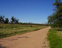
Griffin Avenue. What was once a bustling main street through The Flat is now a county road cutting through the Brazos River bottom land. A few remnants of stone foundations and scatters of patinated glass and ceramics are all that remain of the nineteenth-century boom town frequented by such frontier notables as Doc Holiday, Wyatt Earp, Lottie Deno, and John Wesley Hardin. Photo by Susan Dial.
tent scene
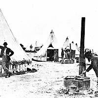
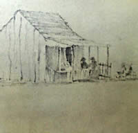
Tent scene in the 1860s. The tall circular tents with vertical posts as base were known as canvas picket cottages, many of which were used at Fort Grffin for lack of more-permanent housing.

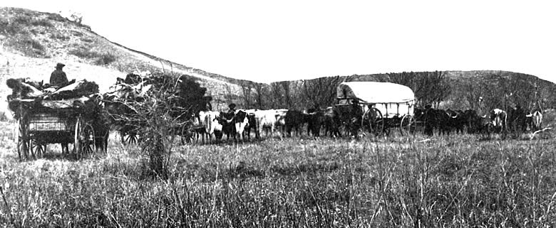
The U.S. Army's forts on the northwestern frontier of Texas were bound tightly to the ebb and flow of warfare with the Plains Indians. As each post outlived its purpose and was abandoned, civilians who had congregated nearby faced an uncertain future. Fort Griffin in its heyday spawned one of the liveliest and most notorious settlements in the West. The fort was the longest continuously-occupied post in the region, but the town that took its name barely survived the Army's departure in 1881.

The post that became Fort Griffin was established in the summer of 1867 by companies of the 6th Cavalry. The original site was in the bottoms of the Clear Fork of the Brazos River, a few miles downstream from the 1850s site of Camp Cooper. It was originally named Camp Wilson, for a recently deceased 6th Cavalry lieutenant, Henry Wilson. In 1868, it was renamed Fort Griffin, in honor of Colonel Charles Griffin, the departmental commandant who had himself recently died. More than just a name change was involved, however, as the post was moved away from the unhealthful bottoms to an adjacent plateau.

In later years, the location would be called "Government Hill" by some local residents. To the west, Collins Creek flowed around the base of the hill into the Clear Fork, and the creek served as the fort's water source for a time. A stronger stream east of the plateau furnished a location for a sawmill, and would be named "Mill Creek."

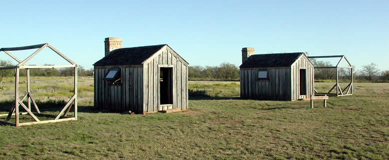
The scant architectural remains of both the fort and town belie the brief, but significant, life of each. The fort's bakery and powder magazine have been restored, and partial walls of the administration building and sutler's (post trader's) store still stand, along with a chimney from one of the officers' quarters. Foundations of numerous other buildings are visible on the grounds. Reconstructed frame buildings represent the size and style of enlisted quarters and mess.

Even less remains of the town below the hill, known primarily as "The Flat," but also as "Buffalo Town, "Fort Griffin," and, simply, "Griffin." 
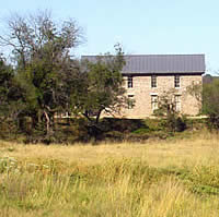
The townsite is on private property, but is accessible by county roads. Its sole surviving building is its first all-stone structure, the Masonic lodge and school house, built in 1878 and restored by the current owner. Foundations of other buildings are visible, and a number of them flank the current county road running from the base of Government Hill to the place where the old Fort Richardson road crossed the Clear Fork. This road was "Griffin Avenue," the main street of the town, in the late 1870s.

As a military establishment, Fort Griffin was something of an afterthought of the Army throughout the life of the post. Plans for substantial permanent structures were drawn and approved, but most were never consummated. The Army had to request funds from the U.S. Congress for building materials, transportation, and skilled labor for each of its significant construction projects. In the meantime, temporary quarters were built from whatever local materials could be obtained, by enlisted personnel with whatever time and skills were available among them.

The Army high command never could quite get around to Fort Griffin, so local commanders made do with what they could cobble together. For the most part, that was "rawhide" lumber—so named because of its similarity to untanned, or "green," cattle and buffalo hides—milled at the nearby stream and fashioned into barracks and other buildings by whatever infantry companies were not on campaign. Foundations were chiseled from local limestone, possibly quarried from the base of the hill or hauled from nearby streambeds.

But the rawhide lumber shrank and warped as it dried, so that the wood was little better than mesquite brush as a defense against wind and rain. A favored alternative was "picket" construction—straight oak, pecan, and elm trunks and limbs set on end in shallow trenches and chinked with cattails, brush, rock, and mud. The alternative for many enlisted personnel was long-term use of the Army's 
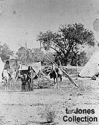
short-term shelter, the canvas tent.

Administration building
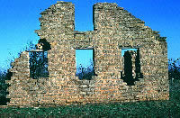
The administration building was the "nerve center" of a frontier army fort, the place where orders would be issued and received. Photo by Lester Galbreath.
.
sergeant's quarters
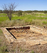
Stone foundation of one of the sergeant's quarters. Constructed of wood, the building, like many of the other frame structures at the post, did not survive. Photo by Susan Dial.
sutler's store
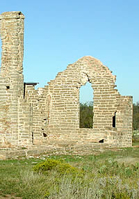
Sutler's Store. The post sutler was licensed by the Army to sell merchandise to soldiers. The store served much the same function as the post exchange of the modern Army. Photo by Lester Galbreath.
The Flat
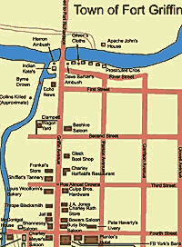
History on every corner. The map of the short-lived but colorful town known as Fort Griffin or The Flat evokes tales of the gamblers, outlaws, buffalo hunters,cowboys, and prostitutes who at one time crowded the dusty streets. Adapted from map reconstruction by Lester Galbreath.
jail
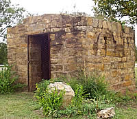
Temporary home to outlaws, drunks, and scoundrels, the jail at The Flat now stands overgrown at its new site in the town of Albany. Photo by Susan Dial.
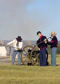
Impressive or not, Fort Griffin was to become a major base for the campaigns that would finish the Comanche and Kiowa as a threat to settlements on the northwestern frontier.
:barracks
Constructed of green "rawhide" lumber, buildings at the post tended to warp and could not withstand the elements. Here, two barracks for enlisted men have been reconstructed next to empty frames that mark the positions of others. The diminutive barracks each typically housed six men. Photo by Lester Galbreath.
Cannon drill
Cannon drill. History interpreters run through the drill of cannon loading and firing during an event at Fort Griffin. Photo by Susan Dial.
mess hall
Reconstructed mess hall at Fort Griffin, where soldiers were called for meals typically heavy on beans, beef, and bread. Photo by Lester Galbreath.
Foley and his wife
Sgt. James Foley and wife, Rachel. Foley, who lived at Fort Griffin with his wife and child, served with the 4th Cavalry in the Red River War. Photo from Robert Nail Collection, courtesy of The Old Jail Art Center, Albany. Click to see Foley's family.
lady
Unidentified woman at Fort Griffin, circa 1867-1875. Photo courtesy of Texas Parks and Wildlife, Fort McKavett SHS Archives.

Throughout the late 1860s, the Army leadership was marking time in Texas, waiting for the government to sort out its relationship with the Plains Indians while it occupied itself primarily with Reconstruction duties in the interior of the state. Conditions on the frontier—among the soldiers as well as the settlers—suffered from an absence of a definitive military strategy.

The Army's attitude changed in 1871, but conditions at Fort Griffin did not. William T. Sherman, commanding general of the Army, and Randolph B. Marcy, inspector general, passed through Fort Griffin on an inspection tour of the frontier posts. Sherman—who was making his first trip to the region—was skeptical of the need for a strong military presence on the frontier, believing that the outcry by Texas politicians was motivated by a desire to divert the Army's attention from its Reconstruction duties. Marcy saw instead how severely the civilian settlements had been depopulated since his last visit in the 1850s. Neither, however, was favorably impressed with Fort Griffin.

Impressive or not, the post would soon become a major base for the campaigns that would finish the Comanche and Kiowa as a threat to settlements on the northwestern frontier. Sherman and Marcy narrowly escaped a Kiowa ambush as they traveled from Fort Griffin to Fort Richardson. Jolted out of his skepticism, Sherman ordered Colonel Ranald Mackenzie, commanding the 4th Cavalry at Fort Richardson, into action.

Mackenzie had only recently taken command of the regiment, and had moved its headquarters from Fort Concho to Fort Richardson. Raids on the northwestern frontier were believed to be conducted by Comanche and Kiowa from the Fort Sill reservation in the Indian Territory, and Fort Richardson was the post best-positioned between the reservation and the hard-hit white settlements. But non-reservation Comanche were suspect also, and they inhabited the Llano Estacado, well to the west.

Fort Griffin, farther west than Fort Richardson, was used as a rendezvous point and supply base for Mackenzie's troopers during the campaigns of 1871-1872. The 4th Cavalry's route from the Clear Fork to the High Plains became known to later travelers as the "Mackenzie Trail."

These were long-range expeditions, leaving from established posts with heavy supply columns, guided by reliable Tonkawa scouts into uncharted territory. The first, departing in August, 1871, resulted in no engagements. The second lasted from late September to early November, and started ignominiously with Quanah's Quahadis capturing 66 of Mackenzie's horses while the cavalry was encamped. Two additional engagements resulted in light casualties, including the wounding of Mackenzie in a fight at Blanco Canyon near the headwaters of the Brazos.

Mackenzie's third campaign prompted a definitive engagement in late September, 1872, in which soldiers of the 4th Cavalry and 24th Infantry, guided again by Tonkawa scouts, attacked a Kotsoteka and Quahadi village of 175 lodges on the North Fork of the Red River. The soldiers captured more than 100 Indian women and children, and a herd of about 800 horses. The Comanches recaptured most of the horses by the next day, but Mackenzie took the prisoners to Fort Concho, from which they later were transferred to Fort Sill.

artifacts
Reminders of a soldier's stay at the fort: artifacts found during archeological excavations at Fort Griffin. Top row, engraved stems of clay pipes and oval lens from eyeglasses; middle row, brass uniform buttons dating to an 1850s to 1870s time period; cartridges at bottom are of military issue. Photo by Susan Dial. TARL Collections.
Foley's house
Sketch of Sgt. Foley's house, 1872, by Miner Kellogg. Note perambulator in front, perhaps carrying the Foley baby.
Tonkawa village
Tonkawa village near Fort Griffin, at the edge of The Flat. In the 1870s, the Tonkawas took in a small band of Lipan Apaches who sought protection from the Comanche.Read Lipan letter to Tonkawa. Photo courtesy of Lawrence Jones, III.
Soldiers and Tonkawa
Soldiers and Tonkawa Indians at Fort Griffin, circa 1870. The Tonkawa were valued scouts for the Army and served under Mackenzie in the Red River Campaign. Following the war, they were moved onto a reservation in Indian Territory.
hunters
With wagons piled with buffalo hides, freighters make their way to the nearest market town to sell and ship their goods. Photo courtesy of the Texas State Library and Archives.
Buffalo hunters' camp, near Evans Creek, Taylor County, Texas. Taylor County and the town of Buffalo Gap were in the heart of buffalo-hunting territory. Photo courtesy of Lawrence Jones, III. View large image.
cattletrail
Drovers trailed thousands of head of longhorn along a route stretching from south Texas to Dodge City, Kansas.
buffalo hide market
The buffalo hide market, centered in Fort Griffin during the 1870s and 1880s, brought a booming business to the Conrad and Rath store at The Flat. It supplied hunters, ranchers, soldiers, and townspeople with everything from food to calico cloth during the town's heyday. The two owners also maintained a store at the post.
courthouse
Courthouse in Albany, county seat of Shackleford County. The impressive structure, built in 1883, reflects the prosperity that was anticipated by area ranchers and merchants even after the Army abandoned Fort Griffin. Photo by Susan Dial.


Whatever they may have accomplished tactically, Mackenzie's campaigns also mapped the bison range from Fort Griffin into eastern New Mexico. Bison—or buffalo—hides had been a popular trade item on the fringes of the Plains for centuries, but they became big business in the early 1870s after industrial uses for them were discovered by New England manufacturers. By 1874, hunters were swarming onto the plains from Dodge City and the town of Fort Griffin, which began to boom as a hunter supply and buffalo hide shipment point. A Comanche, Cheyenne, and Kiowa attack on a hunter's camp near the old Adobe Walls trading post in the Texas Panhandle precipitated the Army's final solution to the southern Plains Indian problem—the "Red River War" of 1874-1875 (see TBH's Red River exhibit to learn more).

Mackenzie's 4th Cavalry had to travel from Fort Clark, near the Rio Grande, for this expedition, and is credited with the climactic engagement at Palo Duro Canyon in late September, 1874 . But the fight at Palo Duro was not the end of the campaign, and units based at Fort Griffin contributed materially to its outcome. Lieutenant Colonel George Buell, commanding Fort Griffin, led an expedition of 9th Cavalry, 11th Infantry, and Tonkawa scouts that attacked and scattered Kiowa villagers near the Canadian River in the Indian Territory in a mop-up expedition known as the "Wrinkled Hand Chase" because it was conducted in an unusually wet fall and winter. Quanah's Quahadi band surrendered at Fort Sill the following June.

The last military engagement involving troops from Fort Griffin occurred on April 9, 1877. A band of Quahadi under a leader sometimes known as Black Horse left the Fort Sill reservation to hunt buffalo and to make war on white buffalo hunters. Among the camps attacked was that of Pat Garrett, later to be sheriff of Lincoln County, New Mexico, and killer of "Billy the Kid." A company of 10th Cavalry "buffalo soldiers"—black enlisted men commanded by white officers—tracked the band to Lake Quemado in the Texas Panhandle, where a sharp fight resulted in the deaths of Sergeant Charles Baker and four Comanches. The soldiers captured 69 horses.

By that time, the slaughter of the southern buffalo herd was well under way. The Texas Plains were hunted out largely between 1874 and 1878. The hide business at Fort Griffin gave up its status as an economic engine with the advent of cattle trailing through the Clear Fork country.

The region had been instrumental in the development of the Goodnight-Loving cattle trail, which sent cattle from the northern Texas frontier to the southwest along the old Butterfield stage route, then north along the Pecos River into Mexico and Colorado. That trail, and Chisholm Trail, which passed by Fort Worth on the way to Abilene and Wichita, Kansas, had been the preferred routes for sending Texas cattle to northern markets. The Western—or "Dodge City"— trail opened in 1875, and by the end of the 1870s had surpassed the Chisholm Trail as the preferred route of drovers from south Texas. The Western Trail passed near Fort Griffin, and the town became the last important supply point on the route to Kansas and points north.

"Cow town," "hidetown," "scabtown"—the village on "The Flat" between Fort Griffin and the Clear Fork became a frontier boom town of hunters, cow men, a village of Tonkawa Indians who served the Army as scouts, and a variety of merchants and predators. But, like many such towns, it could not sustain itself after the boom. Local ranchers began to avoid the rowdy village, and nearby Albany won the contest to be the seat of government for Shackelford County. The town of Fort Griffin would begin to wither away after the Army left and the closest railroad spur stopped at Albany.

With the Comanche and Kiowa confined to the Fort Sill reservation, the purpose of the northwestern frontier posts was accomplished. Fort Richardson was abandoned in 1878. Fort Griffin had been periodically recommended for abandonment since 1873, and departmental commander Christopher Auger had characterized the post as "unfit for human habitation." The Army had invested comparatively little in Fort Griffin, and in the performance of its mission it had been a bargain. It concluded its service on May 31, 1881, when the last remaining infantry company lowered the nation's flag and marched away.

Henry Crawford
Buffalo hunter interpreter Henry Crawford cooks up a pot full of buffalo tongue with onions during a special event at Buffalo Gap Historic Village south of Abilene. The Gap was a prime hunting ground during the 1870s to 1880s. Photo by Susan Dial.
stew
The finished product, ready to sample. Crawford's recipe calls for the tongue, extracted from the skull with pliers and knife, to be first boiled for several hours, then braised over the coals with a layer of onion. Photo by Susan Dial.
Western Trail marker
Marker for the Western Trail south of Abilene, Texas. From the late 1870s to 1880s, thousands of Longhorn cattle were herded up this trail from Texas ranches to market in Dodge City, Kansas. Photo by Susan Dial.
doll
Dolls made by Tonkawa Indians given in 1867 to Sallie Reynolds Matthews, 8-year-old daughter of a pioneering family on the north central Texas frontier. The objects now are on display in the Old Jail Art Center, Albany. Photo by Watt Casey.