Investigations
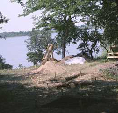
Panoramic view of the Mitchell Ridge site as it appeared in 1989, looking southwest across Eckert Bayou. The site is concentrated along crest of the ridge, which is marked by the larger trees seen in the background to the left. Assembled from photos taken by Lou Fullen. |
|
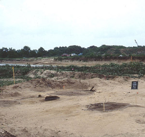
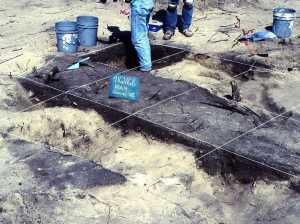
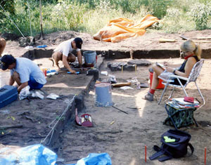
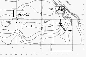
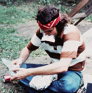
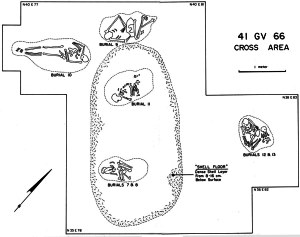
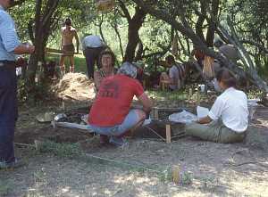
The archeological investigations of the Mitchell Ridge site spanned almost two decades. It was first documented in the spring of 1974 by avocational archeologist Lou Fullen in advance of the planned development of an upscale residential area known as Pirate’s Cove. Charles Magan, the manager of surveying and drafting for the Mitchell Development Corporation, had called on Fullen after recognizing prehistoric and historic artifacts visible on the site’s surface. Fullen searched the area and realized that a very large archeological site existed along the raised terrain that became known as Mitchell Ridge. It was obvious that the site needed to be investigated before the area was developed. Fullen enlisted the help of several fellow members of the Houston Archeological Society (HAS) and they continued exploring the site and dug several test pits. Realizing that the site merited more thorough research, Fullen contacted professor of archaeology Frank Hole at Rice University. In the fall of 1974 archeology students from Rice began more systematic testing of the site with the permission of Mitchell Development. Over weekends during the fall of 1974 and spring of 1975, the Rice University students tested various accessible areas of the site with the assistance of the HAS. Rice graduate student Barbara Burger (later Barbara Bruce Atkins) took charge of the investigations with the hope that the work might become her dissertation research. At the time very little was known about the archeology of Galveston Island. In the early 1960s, a prehistoric cemetery had been discovered by accident during construction work by the Jamaica Beach Development Company only five kilometers (2 miles) down (west) the island. The archeological site encompassing the cemetery eventually became known as Jamaica Beach site (41GV5). Most of the site was destroyed by heavy machinery, however, the construction work did stop when human bones were struck. Local artifact collectors quickly began digging into the burial area and the finding of human remains quickly became known to the public through newspaper articles in Galveston and Houston papers. Thousands of interested people were said to have come to see the spectacle. Fortunately, members of the Houston Archeological Society led by geologist Raymond Ring were able to salvage at least some information and some of the burials, at least 17 of which had been encountered. Several of these were later studied by researchers and reported by Lawrence Aten, the first professional archeologist to really concentrate on the Galveston Bay area. By the early 1970s a few other sites had been recorded on Galveston Island, but little else was known about the native occupations of the island except by intriguing historical accounts including those of the infamous pirate, Jean Lafitte. The earliest and in many ways the most important account was that of the Spaniard Alvar Nuñez Cabeza de Vaca, who was shipwrecked on Isla Malhado, or Island of Misfortune, in 1528. As discussed in the Ethnohistory section, Malhado is argued by many historians to have been Galveston Island. Cabeza de Vaca lived first with either the Han or the Capoque Indians, two groups speaking different languages that were said to live on the island. Some researchers have argued that the Han were one of the groups later known as the Karankawa. The precise identify of Malhado and the Han are still debated, but in the 1970s most Galveston Island history buffs as well as many historians and Houston-area archeologists were convinced that the island had been inhabited by the Karankawa among whom Cabeza de Vaca had first lived on Galveston Island. In a 1976 article in the Rice University Review, Burger expounded on this idea and argued that the Mitchell Ridge remains were those of the Karankawa (Download PDF). In the early summer of 1975 the Houston Archeological Society held a two-week field school at the site to assist Barbara Burger. That summer a small grant from the Galveston-based Harris and Eliza Kempner Fund covered the cost of a 10-member student archeological crew from Rice to investigate the site for six weeks. The next spring (1976) funding from the Mitchell Corporation allowed Burger to bring an archeological crew for an additional three weeks. During the sporadic 1974-1976 investigations various areas of the large site were explored and tested. Most excavations were done by hand using 1-x-1 meter units, but several shallow trenches were dug using heavy machinery in open areas of the site as well. The overall site area was plotted as over 600 meters in length and some 50-300 meters in width, with the main axis along the ridge. A site grid was established that was oriented such that E-W ran along the axis of the ridge and the island. This followed the local habit of referring to Galveston Island as having a West end (San Luis Pass) and an East end (facing Bolivar Peninsula). The Gulf side of the island is known as Island North, while the West Bay side is known as Island South. Thus, in true cardinal directions the grid ran northeast-southwest. Testing and excavation was carried out in seven widely separated areas of the site given convenient mnemonic names such as the Cutbank Area and the Cross Area. These areas were chosen to concentrate on those areas where artifacts were common on the surface as well as to take advantage of the few cleared areas of the site and equipment access routes (unpaved roads). In several areas where dense deposits or features were encountered, small irregular blocks of conjoined 1-x-1 meter excavation squares were excavated. The sandy deposits containing archeological materials were thin, generally less than 50 centimeters (20”) and averaging about 30 centimeters. The finding of hearth features, shell deposits, and several burials led to the recognition that the site had considerable research potential to reveal the prehistory of Galveston Island. 1978 TAS Field SchoolIn June of 1978 the Texas Archeological Society (TAS) held its 17th annual field school on Galveston Island. The major research emphasis was on excavating the Mitchell Ridge site. Barbara Bruce Atkins (formerly Barbara Burger) served as field director. With a recorded attendance of 326 members, the 10-day effort was the Society's largest field school until well into the 1980s. Although some TAS crews worked on site reconnaissance and on documenting certain other sites, most worked at Mitchell Ridge. Based on the results of the 1974-1976 work, excavations were concentrated in three areas of the site the Cross Area, the CC Area, and the Burial Area. |
|
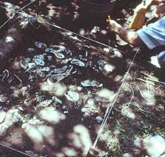
A TAS member uncovers a section of a dense oyster shell layer in the Cross Area excavations in 1978. This feature was labeled as a "shell floor," and was hypothesized to represent the floor of house. Later work suggested it was more likely an ordinary shell midden, a refuse deposit from the consumption of oysters. Photo by Norman Flaigg, TARL Archives. |
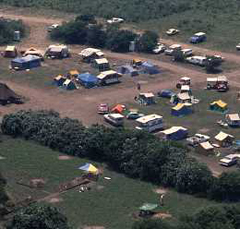
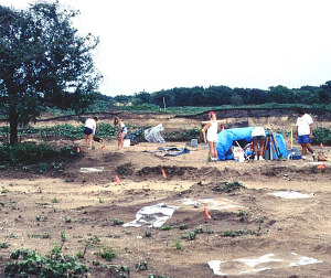
Aerial view of the tent camp of the 1978 TAS field school. With a recorded attendance of 326 members, the 10-day effort ranked as the Society's largest annual field school until well into the 1980s. The tent camp was located at the west end of the site. Photo by E. Mott Davis, TARL Archives. |
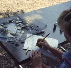
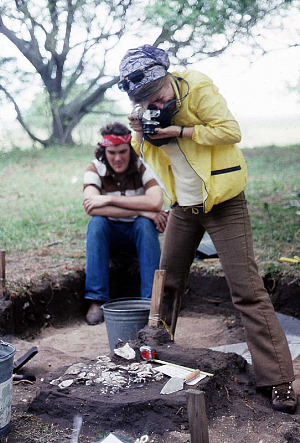
TAS member catalogues the contents of an excavation “unit level” bag, one that has many shells and shell fragments and what seem to be small fragments of iron and glass. There were several historic houses on the site and much evidence of 20th century activities. Photo by E. Mott Davis, TARL Archives. |
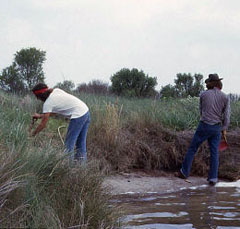
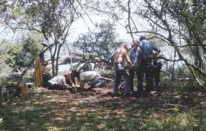
TAS members cutting back the eroding edge along Eckert Bayou to identify stratified deposits in the "Cut Bank" area. Photo by E. Mott Davis, TARL Archives. |
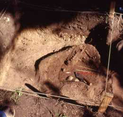
Dog skeleton uncovered in the Cross Area during the TAS Field School. Although several such animal burials were suspected of being prehistoric features, they proved to be pets buried by area residents earlier in the 20th century. Photo by Norman Flaigg, TARL Archives. |
Excavation units in progress during the TAS Field School in the Cross Area overlooking Eckert Bayou. Photo by Wallace Williams, TARL Archives.
|
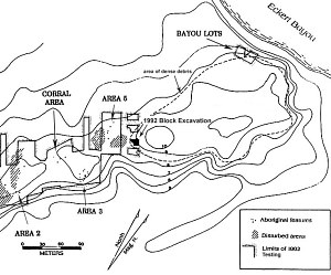
| With the conclusion of the TAS field school, the first period of site investigation ended. Overall, the 1970s work resulted in the excavation of over 350 square meters, a sizeable figure made possible because of the sandy soil and because most of the units were shallow. A large sample of cultural materials were recovered including over 15,000 aboriginal sherds and numerous stone tools, animal bones, and shells. Thirteen human burials had been documented. FiascoFollowing the conclusion of the TAS field school, and some additional field work that took place in the summer of 1978, the large volume of artifacts, samples, and records amassed during the 1970s investigations were stored at a Galveston museum, where Atkins had been given work space and hoped to do her analysis. Regretfully and inexplicably, while Atkins was away from Galveston for an extended period in the following year, untrained museum personnel removed many of the artifacts from the labeled sacks, losing or stealing some items, and mixing together other materials, resulting in the tragic loss of a great deal of information. The Texas Historical Commission stepped in 1980 to remove the Mitchell Ridge collection from the museum and these were turned over to TARL for curation. Fortunately, during the Galveston fiasco, the burials were being safeguarded by members of the HAS. These too were later turned over to TARL. Some of the 1970s field and laboratory documentation—field notes, drawings, photographs, and catalog sheets—were turned over to TARL, but not most of the most critical records, including Atkins' field journal, original field maps, and drawings, feature records, and burial records. The loss of these records has never been explained. The museum fiasco helps explain why Atkins did not complete her analysis (nor her graduate studies). She did write an unfinished manuscript of a site report that provides an overview, but little meaningful detail of the 1970s work. After 1980 the results of the first major phase of site investigations languished. A short summary of the TAS field school appeared in the 1985 Bulletin of the Texas Archeological Society. (Download PDF). 1992 ExcavationsThe 1970s data strongly suggested that the cultural materials and intact deposits, including human burials, were concentrated at the eastern end of the site. The Woodlands Corporation (an offshoot of the Mitchell Development Corporation) agreed to donate that portion of the site to the City of Galveston so it could be preserved as a State Archeological Landmark. A small portion of the site lying between the Cross and CC Areas was also placed on the National Register of Historic Places. Subsequently, the Corps of Engineers issued a permit to the Woodlands Corporation for the development of an area that included the western portion of the site, where cultural debris was noted as being extremely sparse. There, “pilot” canals would be dug leading inland from the West Bay side of the island to provide boat access to planned residential units. Soon after the dredging of the first canal began in January, 1992 human remains were encountered and work was immediately halted. Corps of Engineers archeologists accompanied by author Ricklis, then head of the consulting firm Coastal Archaeological Research, Inc., carefully examined the scene. They soon recognized that intact burials were present. This area of the site had an upper dark brown sandy soil 30-50 centimeters thick. Grave pits were found to extend downward into the underlying tan-colored sand and shell hash deposits, making the darker soil within the pits easy to spot. The extent of the burial ground (cemetery area) needed to be determined before decisions could be made concerning the need for further work. Ricklis took on this job. Given that the burial pits seemed to have been dug well below the upper soil, he realized that the darker soil could be carefully stripped off using a large hydraulic excavation machine known as a Gradall in order to search for additional burials. This was done along the planned route of the first pilot canal, resulting in the identification of additional burials. All burials seemed to be confined to the higher area on the ridge which lay above the 8-foot contour line (elevation above mean sea level). Since the planned development would impact a sizable area above the 8-foot contour line of the western part of the Mitchell Ridge site, the Corps of Engineers required that the entire impacted area be machine-stripped in search of additional burials and other aboriginal features. In lieu of a Gradall, which is a relatively heavy and slow machine, a lighter and faster machine called a “maintainer” with a wide blade was used to carefully scrape off the dark sandy soil over a series of strips across the site. This work was closely monitored by the archeology team, who quickly examined and flagged off any potential archeological feature, such as a possible burial pit. Over the course of several months, approximately 18,000 square meters ( 4.5 acres or 1.8 hectares) were exposed at the level of the surface of the light-colored sand/shell hash. Over 100 “anomalies” were documented, of which 50 proved to be definite or probable aboriginal (Native American) features, such as burial pits. Non-aboriginal features, such as historic fence posts, modern trash pits, and burial pits containing historic farm animals and pets (such as goats and dogs) were also encountered. Several large areas 30-50 meters in length were also encountered within which the sediments had been churned by land clearing, leveling, and other modern activities. The archeologists carefully exposed and excavated the aboriginal anomalies by hand using trowels and brushes. The aboriginal features included 22 burial pits, 12 non-burial pits of apparent aboriginal origin, 15 hearths (cooking features), two clusters of post molds representing small circular huts, and a small, dense concentration of cultural debris. During this phase of work the Mitchell Ridge site was a very busy place. The stripping and hand investigations took place more or less simultaneously, with several archeologists monitoring the stripping operation, while others excavated the flagged-off anomalies by hand. In areas where intact upper deposits might be present, the researchers also dug “shovel tests” (small probing holes dug quickly by shovel) in advance of the machine stripping Sure enough, the easternmost area scheduled to be developed was found to contain a layer of relatively dense cultural debris some 15-20 centimeters thick about 20 centimeters below the surface within the dark brown upper sediments. This area coincided with the western edge of the concentrated debris as revealed by the 1970s work. Here the archeologists excavated by hand a series of contiguous 2-x-2-meter units totaling some 74 square meters dubbed the “Block Excavation” area. The conventional hand excavations were intended to sample the upper deposits as well as those intruding into the underlying shell/hash layers. This area yielded abundant evidence of Late Prehistoric domestic occupation including hearths, a small pit, a probable house floor, activity areas, and large samples of artifacts and faunal remains (animal bones). These occupational features were found to date to Final Late Prehistoric period between the late thirteenth and early fifteenth centuries (late 1200s to early 1400s). Following the completion of the field work in July, 1992 the Pirate’s Cove development was allowed to proceed and the analysis phase began. Over the next two years Ricklis and his colleagues analyzed their findings and wrote a 559-page technical report. Several outside consultants carried out specialized studies. These included a thorough bioarcheological study of human skeletal remains by Joseph F. Powell, assisted by Barry W. Baker; a study of the shell artifacts by Meredith L. Dreiss, and a stable isotope analysis by Jeffery A. Huebner that helped reconstruct dietary practices of the individuals buried at the Mitchell Ridge site. |
|