Investigations
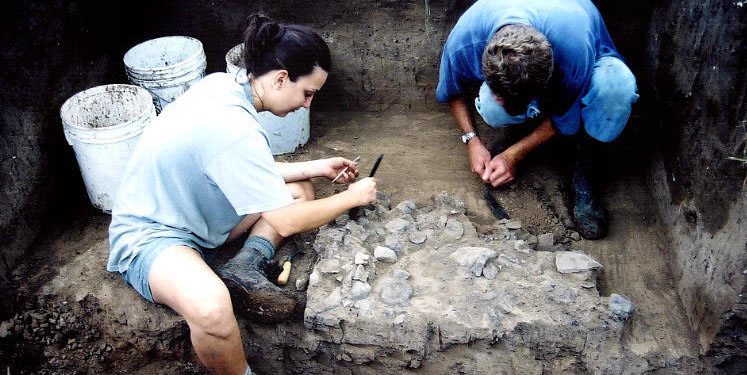
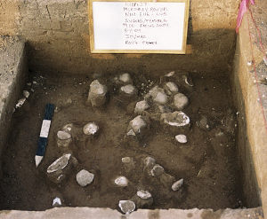
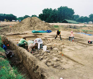
Archeologists from SWCA Environmental Consultants carefully uncover a small rock feature, a "hearth" used by prehistoric peoples for cooking or for warmth. The investigations opened broad horizontal areas using contiguous 2-meter square excavation
units, such as the one shown above, to expose and recover archeological remains. |
|
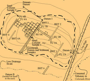
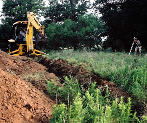
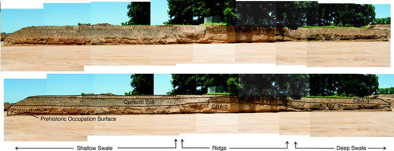
Prior to the development of the Hyatt Regency Lost Pines Resort, an archeological survey of the project area was carried out to determine the presence and significance of cultural resources that could be affected by the undertaking. The archeological surveyors discovered and documented numerous sites, among them 41BP627, the prehistoric campsite now known as the McKinney Roughs site. The site was initially recognized by the presence of burned rocks and stone tools found in exploratory archeological trenches dug through the site using machinery such as backhoes. As the testing confirmed the presence of intact cultural deposits, a final stage of archeological investigation—the data recovery phase—was conducted to fully expose and recover the materials and information the site had to offer. Archeologists dug excavation units by hand to expose small views of ancient ground surfaces buried by flooding from the nearby river. These surfaces contained the living debris left behind by prehistoric campers hundreds of years before. The investigations employed a multi-disciplinary approach, including a variety of different studies critical to interpreting the cultural occupations identified in the McKinney Roughs site. Chief among the concerns was the integrity, or isolable nature, of the surfaces. Were the deposits intact, or had they been disturbed by subsequent campers? Assessing the Site Deposits: The Role of Geoarcheology When first discovered in 2001, two buried layers or zones of burned rock, mussel shell, and lithic debris were identified in backhoe trench walls. Though the materials were moderately dense, the significance and nature of the site deposits could not be clearly defined. Archeologists have learned that, in many cases, dense deposits of materials with large quantities of artifacts may signal multiple occupations on a surface. Although these "high visibility" sites may have received greater attention in the past because of the large numbers of artifacts recovered, their potential for yielding behavioral information about spatial patterning was often limited due to "overprinting" and mixing of the living surfaces. Increasingly, archeologists target smaller sites with thinner occupational layers, such as McKinney Roughs, that provide opportunities for greater evaluation of past behaviors. To better understand the nature of the deposits, geoarcheologists Charles Frederick and Lee Nordt studied the valley structure and how the natural deposits contributed to the development of the site. They determined the site formed from nearly continual deposition of sediments during repeated periods of overbank flooding of the Colorado River between 2100 years ago and today. Importantly, they determined that this periodic flooding had resulted in rapid burial of some of the surfaces, preserving them in place much as they had been left by campers in the past. Prior to 4000 years ago, the Colorado River meandered across the resort valley floor, scouring out sediments as it moved laterally. Then between 4000 and 2000 years ago, the river settled into approximately the location we see today. Sediment deposits began to accumulate, gradually forming the knoll on which the site is located. As small groups of prehistoric humans periodically occupied the knoll, the remains of their occupation were buried by flooding, sealing and preserving the different archeological components. Accordingly, the initial archeological and geomorphological assessment indicated that the McKinney Roughs site was a stratified, or layered, prehistoric site dating to the final stages of Texas prehistory, though its exact chronology had yet to be established. |
|
|
|
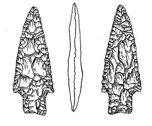
What the Archeology Revealed The subsequent excavations discovered and exposed three discrete prehistoric "living surfaces" that dated to the final Archaic period of Texas, the Transitional Archaic. The evidence suggests the site was abandoned, or only sparsely used, during the subsequent Late Prehistoric period, after A.D. 1200. The overall site investigations recovered a total of 15 cultural features, 2159 artifacts, abundant burned rock associated with cooking features, and 1129 ecofacts (unmodified natural materials) including mussel shell, fish otoliths, and bone. All of the materials were contained in three stratified layers, or cultural components. Each component appeared to have been buried by Colorado River flood deposits shortly after the camp was abandoned. The earliest and deepest of the three components was an occupation dating to about 100 B.C. (2100 years ago), designated the Ensor I component after the style of dart point found in the zone. Small features of burned rock and living debris such as stone tools were located and explored in this component. The second component was slighly later, dating to roughly A.D. 200 (1800 years ago). It was dubbed the Ensor II component. As with the other components, this consisted of a living surface replete with burned rock cooking features, lithic debris from stone tool making, and food remains, predominately mussel shells. The third and most significant occupational surface is the Darl component, an occupation zone that yielded two radiocarbon dates of about A.D. 1150 and A.D. 1100 (850-900 years ago). Obtained from wood charcoal recovered from small hearth-like features associated with the surface, the two dates are later than the commonly accepted chronological range for the Darl type of dart point. Until now, archeologists had estimated that Darl points ranged in age from A.D. 300 to A.D. 750. But the McKinney Roughs investigations indicate this style is significantly later than previously thought. The Darl component comprised a well-preserved living surface with discrete burned rock features, charcoal, stone tools and debitage, and abundant mussel shell, with little or no evidence of overprinting from later occupations at the site. Analyses of the artifacts and features helped explain how and why they were made, used, and ultimately discarded. Of particular concern in this study was constructing an argument for isolable "living surfaces" in the site, developed through the assessment of spatial patterns, site formation processes, and artifact types. Additional special studies were conducted to reconstruct localized environmental conditions and help understand how peoples used the landscape in the past, including microfloral analysis by Vaughan Bryant of Texas A&M and macrofloral analysis of flotation samples taken from various site contexts by archeobotantical expert Leslie Bush. For the most part, however, preservation of charred plant remains and animal bones, with the exception of molluscs (mussel and snail) was poor. Analysis of the freshwater mussel shells recovered from the site (total sample of 1473) was conducted by shell expert Robert G. Howells. His study identified 11 freshwater unionid species from the site, all of which would have been locally available in the Colorado River and its tributaries. A number of specimens display signs of human manipulation, including possible drill holes, notched edges, and indications of burning and heating. Analysis of the snail sample by Andy Malof of the Lower Colorado River Authority revealed 13 varieties of land snail, although the overall sample was too small to determine whether they had been used as a food source. Data from both mollusk studies indicated the environment at the site had periodically fluctuated from arid to mesic conditions over time. |
|