The Darl Living Surface: A Transitional Archaic Camp
|
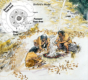
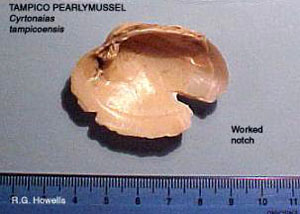
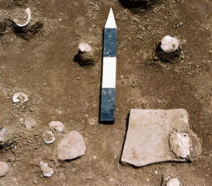
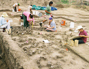
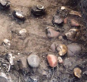
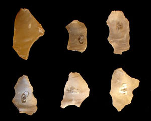
The upper (or latest) Transitional Archaic layer was the best-preserved living surface at the McKinney Roughs site and, accordingly, was the focus of additional interpretive study. Associated with a distinctive projectile point style known as Darl, this layer of deposits is called the Darl component. Analysis of artifacts and features afforded a snapshot overview of some of the economic strategies employed by Darl people. Food remains, including mussel shells, fragments of deer tooth enamel, a fish otolith, and small amounts of bone from large and small mammals, indicated the Darl campers maintained a broad-based subsistence strategy. They hunted and gathered various animals and plants that lived along the nearby Colorado River. Freshwater clams, in particular, were an important food resource. Locally available stone was used for making chipped-stone tools, although tool-making was only a minor activity at the site. Most tasks requiring sharp-edged implements were accomplished with simple expedient tools, such as sharp chert flakes. Other than several Darl points, few formal tools were recovered. The Darl campers employed at least two different cooking techniques: oven cooking in small basin pits and stone boiling, using heated stones which probably were placed in pouches or hide-lined pits filled with water. Mussels may have been cooked using this method. Ground stone, such as a mano (handstone) and fragmentary metate (grinding slab) found in the component, indicates processing of foods, likely wild plants and nuts. The presence of small cooking features, rather than large ovens, represents small-scale processing of resources rather than intensive extraction. In other words, these were small, short-term cooking episodes carried out by small groups of people. Analyzing the Darl Living SurfaceFollowing the identification and classification of artifacts and features, the evidence was analyzed in an attempt to reconstruct the prehistoric living surface, or campsite, itself. The chief focus was a search for patterns in the distribution of the material remains that might show what people had done in the past and where. Several methods were employed to discover and interpret patterns: spatial analyses, statistical analyses, and ethnographic analogy. The first two approaches examine non-random clustering of artifact types that suggest patterned cultural behavior. Ethnographic analogy takes those findings a step farther. This entailed a documentary survey of contemporary and historical hunter-gatherer societies that still practice (or practiced into the historical period) traditional lifeways, searching for insights into behavior and "near universal" patterns that could be compared to the record at McKinney Roughs. Drop-Toss Zone Patterns and the Identification of Tool KitsBased on studies from around the world, a number of researchers such as anthropologist Lewis Binford have documented how hunter-gatherers use and discard tools and trash on a campsite. Typically, an individual working around a hearth or other such feature (termed “site furniture”) usually works within a meter or so of the activity locus and tosses trash and other non-useful debris beyond the work area into what is called the toss zone. The work area where objects are incidentally set or dropped is known as the drop zone. In the search for meaningful spatial patterns in the Darl component, the concept of drop and toss zones provided an analytical framework for identifying activities, discard patterns, technological organization, and other aspects of past society. Applying this model to the site data, based on the principle that site furniture, such as hearths and grinding stones, represents activity centers in campsites, five likely activity areas were identified on the Darl surface. These provided centroids (center points) from which drop and toss zones could be reconstructed. Four areas were around hearths and one was around a mano and metate. Once these areas were identified, a 1-meter radius was drawn around each centroid to serve as an analytical unit that hypothetically included the drop zone artifacts. Statistical analyses were used to determine which artifacts were clustered around the focal points of activity, which artifacts were significantly situated in the areas beyond the foci, and which artifacts were randomly or equitably scattered. Based on the findings, projectile points, bifaces, bifacial edge-modified flakes, and debitage are clustered within the drop zones. Why the projectile points—some of which were complete and still usable—would have been dropped and left behind is rather puzzling. Possibly they became lost among the debris or, alternatively, intentionally left for later use. Regardless, there is a significant clustering of projectile points within the drop zones. In the outlying or surrounding toss zones, a variety of waste material was found, including mussel shell, small stones, burned rock, and chipped-stone debitage from tool making. |
|
Explore Darl Component map by rolling over and clicking on zones. |
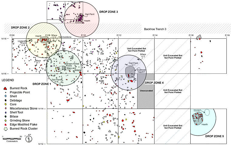
Interactive map of the central portion of the Darl Component showing activity loci and inferred "drop-toss" zones. Worldwide ethnographic studies of contemporary hunter/gatherers have revealed nearly universal patterns of discard whereby individuals working around a hearth or other focal point will set down or drop objects within an approximately 1-meter radius. Refuse generally is discarded (tossed) further, outside of that radius. |
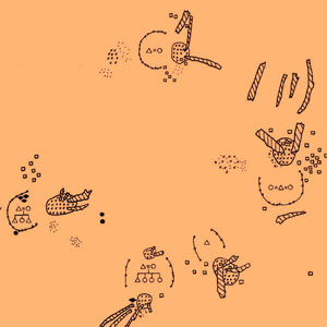
Interpretation of Drop Zone DataAnalysis of the spatial distribution of materials using an ethnographic model of drop-toss zones indicates differential discard patterns. Formal stone tools are found around the features in the drop zone and debris such as mussel shells are found in the surrounding toss zones. Stone cores and expedient flakes are scattered across the surface, but utilized flakes made on bifacial thinning flakes are significantly clustered within the drop zones. In other words, the data show clear spatial patterning, rather than random distributions, which are interpreted as the result of cultural behaviors, on the Darl occupational surface. Binford hypothesized that two types of artifacts should be found within the drop zone— those that are dropped, which are often smaller pieces such as bone splinters, and those that are set down like a coffee cup, to use his example. The set-down items are those intended for further use. In the Darl component, projectile points, trimmed flakes, and bifaces (such as knives) are interpreted as items being actively used to accomplish a task, or objects being maintained or worked on (such as points being hafted or resharpened). On a wider scale across the site living surface, the "drop-toss" zone analysis indicates spatially segregated activity areas around central loci. These broad patterns are similar to those observed in contemporary small hunter-gatherer camps with clusters of houses (huts). Lacking a more extensive view of the living surface, however, the location of possible houses could not be clearly discerned. Although additional excavations might have identified traces of such features, forager huts are often very subtle in the archeologial record and can only be inferred to have existed. Most of the evidence on the site derived from short-term, intensive food-gathering activities. Several other ethnographic studies were consulted as possible correlates for the McKinney Roughs site. A plan map of a hunter-gatherer camp in the African Kalahari Desert (shown at right) shows overall layout, including a circular cluster of activity areas with hearths, small huts, and tool kits as well as areas where trash, including bone and other materials, was discarded. Stones used for processing foods and other uses are nearby each of the house areas. There the campers processed quantities of mongongo nuts. While the five activity areas defined on the McKinney Roughs surface cannot be associated with huts or other structures, it is possible they were situated around such features at the time and evidence has not been preserved. Collectively, the activity areas and debris represent contemporaneous and probably interrelated group activities similar to the ones depicted in the figure. At McKinney Roughs, processing mussel shell appears to have been the obvious chief activity rather than mongongo nuts as in the Kalahari case. Based on cross-cultural hunter-gatherer evidence, anthropologist Polly Weissner has noted that a forager residential base often occupies about 250 square meters. To the extent that the parameters of the Darl camp surface were fully established at McKinney Roughs, the site measures approximately 12 to 15 m east to west by about 25 to 30 m north to south, or about 300 to 450 square meters and thus within the expected range of a forager residential base. Thus, although the Darl camp may have been large enough to qualify by this measure as a forager residential base camp, there is insufficient evidence to support this possibility. Summing Up the EvidenceSeveral interpretations can be made about the distribution of Darl component materials. The processing of mussel shells as a foodstuff was obviously a common site activity. Mussel shell distribution is interpreted as a toss zone. Items such as metates, hearths, and fireplaces are structural site elements abandoned or discarded where they were utilized. The distinction reveals activity areas and even specific locales where a person or person was situated. For example, in one area a metate and an associated mano were found surrounded by scattered materials, as well as a 50 cm diameter area devoid of artifacts. The area is interpreted as an occupational locus where a person, likely a woman, used the grinding stones, perhaps in the processing of mussel shell, discarded the mussel shell in a toss zone and likely left the remaining aspect of the tool kit. At McKinney Roughs, the Darl component is interpreted as a small foraging camp which contained several activity areas in roughly circular clusters. Various activity areas and possibly tool kits are evident in the patterns across a living surface that likely formed over the course of a single occupational episode. These activity areas reflect the use of space by the inhabitants of the site as they processed foodstuffs, notably mussels, foraged from the surrounding riverine environment. This view of day-to-day activities of prehistoric humans living 1000 years ago is rare among archeological sites. |
|