|
In this Section:
|
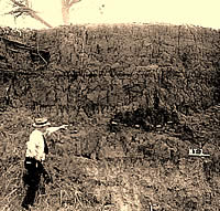
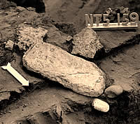
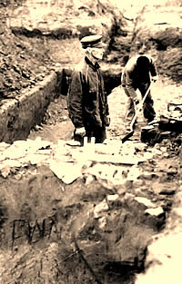
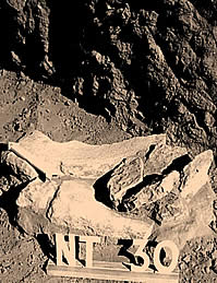
An unknown investigator points to
a lens of telltale burned rocks that alerted archeologists
to a buried midden, or camp refuse area. The stones
were uncovered as part of Excavation 1. Photo from TARL
archives.
|
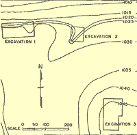
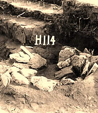
Contour map of the Harrell site,
showing locations of the three excavation areas. Excavation
area 3 was on top of the third terrace, some 40 feet
above low water level. Map from Krieger, 1946.
|
Tools of the excavators. Shovels
and picks hang cleaned and ready for the next day's
work. Photo from TARL archives.
|
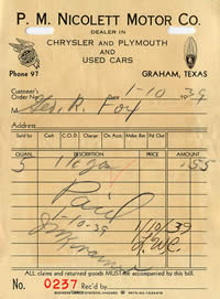
Gasoline
was cheap by today's standards, a mere $.11 per gallon,
but likely was not considered so in the depressed economic
conditions of the 1930s. Document from TARL Archives.
|
|
The WPA was both boon and bane to American archeology.
|
Manos and metates, implements used
for grinding corn, seeds, or nuts, were found among
the midden refuse deposits. Photo from TARL archives.
|
|
The systematic approach that A.T. Jackson laid out
was an important step forward for Texas archeology.
|
Workers and bosses wearing many hats
struggle for position as prehistoric occupation areas
are exposed at the Harrell site. Barns and outbuilding
of the farm and garden area on which Excavation 3 investigations
were located are in the background. Photo from TARL
archives.
|
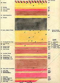
Layer upon layer of silts and flood
deposits—creating the so-called "layer-cake"
stratigraphy—has been captured in this hand-colored
field profile of the bluff. Archeologists found only
sparse artifacts throughout, although they extended
to a depth of more than 20 feet. Profile by Raymond
Bland; TARL Archives.
|
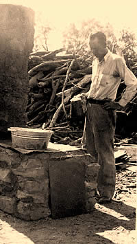
A WPA worker keeps a watchful eye
on a pan heating over a twentieth-century "cooking
hearth." Photo from TARL Archives.
|
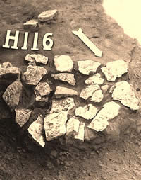
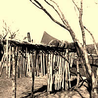
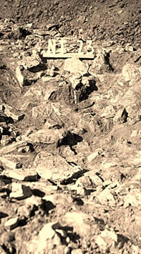
A typical hearth, formed of a single
layer of burned limestone fragments and measuring about
three or four feet across. Photo from TARL archives.
|
|
In hindsight, the WPA archeologists simply lacked
enough knowledge of geology and sedimentation to appreciate
what they had found in the second river terrace.
|
Prehistoric cooks constructed this
baking pit by digging a shallow basin and laying small
slabs against the sides. The pit may have seen service
for the cooking of roots or bulbs. Photo from TARL archives.
|
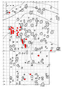
Map of hearths and burials (to the
west, or left, side) in Excavation 3. Burials have been
highlighted in red. Map adapted from Ray Bland drawing,
TARL Archives. (Click to enlarge image.)
|
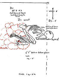
One of the single interments in the
cemetery at the Harrell site. (See the Prehistoric
Cemetery section for more detail.) Drawing from
TARL Archives. |
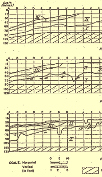
Stratigraphic profiles of Excavation
3, showing the layer of dark midden earth (II) and underlying
reddish sandy clay (I). Note scattered burned rock features.
The unevenness of Stratum I may be due to the digging
in of pits for roasting ovens. Stratum III was a sterile,
windblown sand which sloped to the Brazos side. These
sands were blown up from the riverbed. Profile from
Krieger, 1946.
|
|
In the Fall of 1937, archeologist A.T. Jackson
of the University of Texas at Austin spotted a suspicious
line of broken limestone rocks eroding out of a cutbank on
the south side of the Brazos River just below where its Salt
and Clear Forks came together in southern Young County. Jackson
was searching for Indian campsites in the area that would
be inundated by Possum Kingdom Reservoir, then under construction.
Jackson rightly suspected that the stones marked an area were
prehistoric peoples had built cooking hearths.
He was intrigued because the fire-cracked (or
"burned") rocks were buried by 7 feet of mud and
sand left by countless floods along the sometimes mighty Brazos
River. Here, Jackson realized, was a perfect place for an
archeological excavation that might shed light on the unwritten
history of the region. The property where Jackson found the
deeply buried hearth rocks was part of the M.D. Harrell farm.
He soon obtained the landowner's permission to conduct a major
dig there the following year to search for deeply buried evidence
of prehistoric life.
Jackson's survey was a continuation of a state-wide
archeological survey program begun in the mid-1920s by Professor
James E. Pearce at the University of Texas. Pearce, sometimes
called the "father of Texas archeology," was a visionary
who worked tirelessly to establish an anthropology department
at the university and get the state-wide survey underway.
"Survey" to Pearce meant locating and digging important
archeological sites in different areas of Texas. Unfortunately,
his approach to archeological excavation was not methodical
and his early excavations sometimes were little more than
artifact mining operations.
Pearce apparently believed that by amassing
large artifact collections he would be able to understand
broad cultural patterns. Like many early archeologists, he
had a static view of prehistory and failed to understand that
many of the artifact collections he studied represented thousands
of years of cultural development. Jackson was Pearce's chief
assistant and a former newspaper reporter who quickly became
adept at archeology. He was naturally curious and skilled
at making do with whatever conditions he found himself in
as he traveled across Texas in search of places where important
archeological sites could be found.
In the 1920s, most of the work was concentrated
in the Austin area with brief forays in more distant areas
of the state. Pearce struggled to find adequate funding to
fulfill his vision of sampling the archeology of the entire
state. By the early 1930s the National Research Council of
the National Academy of Sciences had established a Committee
on State Archaeological Surveys to dole out small grants to
universities in different parts of the country so that information
could be salvaged from the areas scheduled to be flooded by
reservoirs. At the time, reservoirs were being planned and
built all across the country to prevent floods, improve water
supplies, and generate hydroelectricity. While such projects
were good for the country, they were also destroying many
cultural resources such as Indian campsites as well as early
historic settlements. To help lessen these losses, the federal
government instigated what would become a three-decade-long
program of "salvage archeology" that was formalized
after World War II.
WPA Archeology
In the 1930s the country was mired in the Great
Depression following the collapse of the stock market in 1929.
Money and jobs were scarce and unemployment ballooned. The
federal government stepped in with what became known as the
New Deal, a set of relief programs designed to get the country
back on its economic feet. One of the most successful was
the Works Progress Administration (WPA), a program that put
thousands of Americans back to work between 1935-1941. The
WPA guidelines called for "useful" projects that
would benefit the public and that could be executed immediately
with a high proportion of the total costs being labor. The
projects also had to be near areas where most of the unemployed
lived, rural Texas being a prime example.
The WPA was both boon and bane to American archeology.
Archeology, as it turned out, was a perfect fit for the WPA.
One or two trained archeologists could oversee the labor of
dozens of unskilled workers. Under the WPA program massive
excavations of unprecedented scale were carried out at hundreds
of archeological sites across the country between 1935-1941,
especially in the south and southeast where the unemployed
were concentrated.
In Texas, many of the projects were administered
through the University of Texas at Austin under Dr. J. Gilbert
McAllister, who took over from Pearce. Pearce died in 1938
soon after he was appointed as the first director of the Texas
Memorial Museum, the creation of which had consumed his latter
years. McAllister was a cultural anthropologist, not an archeologist,
but he proved to be a much better administrator than Pearce.
McAllister continued to rely on A.T. Jackson, but he also
began bringing in academically trained archeologists like
Alex D. Krieger and J. Charles Kelley. The WPA mandate allowed
the UT archeologists to carry out large-scale excavations
in many locales ranging from northeast Texas to central Texas.
In the case of the Harrell site and a series of terrace sites
along the Colorado River upstream from Austin, the make-work
goals were integrated with the fledgling reservoir salvage
efforts funded by the federal government.
A.T. Jackson served as Archeologist in Charge
of the WPA work at the planned Possum Kingdom Reservoir. He
assigned George R. Fox to supervise the WPA excavations there
beginning in the fall of 1938. Not much is known about Fox,
aside from the fact that he returned home to Michigan soon
after the WPA work ended at Possum Kingdom Reservoir was completed.
Fox does not appear to have been trained formally as an archeologist.
Regardless, his notes reveal an organized man who followed
Jackson's guidelines methodically. Jackson, in obvious reaction
to Pearce's lack of methodological rigor, produced a Manual
of Archaeological Field Work in 1937. Carbon copies of this
manuscript were used by the WPA archeologists under Jackson
as a basic guide to field methods. The systematic approach
that Jackson laid out was an important step forward for Texas
archeology.
Jackson's organizational plan for the work at
Harrell and other sites specified that each crew would "consist
of approximately forty-five laborers, three cooks, two clerks,
one draftsman, and an assistant archeologist" under a
"crew archeologist." Fox served as the project superintendent
or "crew archeologist." His assistant was the timekeeper
who kept track of the hours worked by the unskilled laborers.
The clerks typed the daily field notes and many forms, while
the draftsman was in charge of drawing maps and field sketches.
The men in skilled positions were paid at a higher rate and
were chosen because of their qualifications. All of the unskilled
laborers were selected from the "relief rolls" of
unemployed men from north Texas communities.
For a six-month period from the fall of 1938
through the spring of 1939, the M. D. Harrell farm became
a work camp. Barns and outbuildings were joined by a small
village of temporary shelters, clusters of canvas tents for
workers, and makeshift laboratory areas for artifact processing.
Crews wielding shovels and picks methodically excavated 5-x-5'
squares laid out in neat grid patterns in three areas on two
of the river terraces. The center of most of the attention
was to be the family garden plot, high above the other areas.
At the time, the archeologists recognized three
river terraces along the Brazos. The first and lowest was
the modern floodplain which was not present in the immediate
site area. Through time, the Brazos River was slowly carving
its channel southward and eroding the second terrace and creating
the cutbank that Jackson had first examined. The top of the
second terrace was about 22-25' above the normal level of
the river. Major floods could still reach the top of the second
terrace. Further back from the river was the third terrace,
which lay about 36-40' above river level and beyond the reach
of even the worst floods. Modern geological work has shown
that the upper Brazos and its tributaries has a complex set
of terraces that formed at different periods of times and
that have been reshaped by periods of erosion. The "third"
terrace in WPA terms, probably formed at least five to six
thousand years ago.
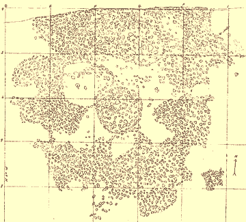
The "Great Midden"
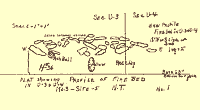
Plan
map of the Great Midden, showing circular pits and hearths.
Field drawing drafted by Raymond Bland; TARL Archives.
Work began on the river edge of the second terrace
atop the bluff where Jackson had spotted the line of hearth
stones 7 feet below the surface. This terrace was being steadily
undercut by the two rivers, a process that exposed the hearth
stones and would have eventually destroyed all the buried
evidence. Excavation 1 uncovered what was termed the "Great
Midden," a rather grand title for what proved to be a
burned rock midden—a sizable accumulation of heat-fractured
rocks nearly 28 feet in diameter, but less than a foot thick.
Within the expanse of burned limestone and sandstone fragments
were three circular depressions—the remains of baking
or roasting pits-filled with ashes and charcoal and little
more.
Today archeologists would take a great deal
of interest in the burned rock midden at the Harrell site.
Unlike the burned rock middens characteristic of the Edwards
Plateau in central Texas, the "great midden" accumulated
on a terrace surface that was soon sealed by flood deposits.
Central Texas middens typically formed on stable surfaces
and sometimes grew to 6 feet or more in thickness and several
acres in extent. Often the traces of the baking pits responsible
for the burned rock accumulation are obliterated by the mass
of rock. In contrast, the burned rock midden at the Harrell
site is preserved in an "incipient" stage early
in its formation.
It is obvious that the "great midden" at Harrell
formed as the result of the use and reuse of the three baking
pits, which can be seen in the photographs and drawings. Based
on ethnographic accounts from many different areas of North
America and on modern experimental work, archeologists now
have a good understanding of the process known as earth oven
cooking. At the Harrell site, like countless other sites in
Texas, plant foods such as roots and bulbs (no animal bones
were found in the midden), were baked in layered arrangements
of heated rocks, green plants, food, and earth known as earth
ovens. The heated rocks held and slowly released stored energy
(heat), which caused the green plants (such as fresh-cut grass)
to give off steam, thus slowly baking the roots in moist low
heat. The green layers also kept the roots from burning and
separated the food from the earth layer. Additional layers
of heated rocks are sometimes added above the food layer.
Capping it all was a thick layer of earth that served as an
insulation layer to hold in the steamy heat.
Some earth ovens likely continued cooking for
as long as 24 hours or more, although the pits at the Harrell
site are relatively small and probably represent shorter cooking
episodes. Once the food was done, the earthen cap, upper rock
layer, and top layer of green plants were peeled back so the
food can be removed. Notice in the photographs how the rocks
are arrayed around the pits. Most of the scattered rocks represent
fire-cracked rocks from earlier ovens that must have been
cleaned out of the pits when fresh, intact rocks were added
at the start of each cooking episode.
While Fox and Jackson had a rudimentary understanding
of how the "great midden" formed, they were sorely
disappointed by the lack of artifacts and soon decided to
abandon excavations in this area of the site. First, however,
the crew cleaned back the bluff face and recorded 25 feet
of multi-colored alternating layers of sands, silts, and clays,
each reflecting a different period of deposition. They also
dug a trench beneath the burned rock midden in search of more
deeply buried artifacts. They were again disappointed by the
lack of what was then considered to be a worthwhile find-a
projectile point or formal stone tool. They did note the presence
of scattered flint chips, showing that prehistoric peoples
were in the area while many of the layers formed.
In hindsight, the WPA archeologists simply lacked
enough knowledge of geology and sedimentation to appreciate
what they had found in the second river terrace. Today the
terrace exposures they created would be carefully studied
by specialists trained in reading the depositional layers,
like those found along the Brazos. Instead of being disappointed
by the sparseness of the artifacts, a good modern archeologist
would realize that here was the opportunity to study brief
moments in prehistory that were sealed and protected from
mixing by the flood deposits. By obtaining radiocarbon samples
from different layers, a geologically minded archeologist
(or geoarcheologist) would be able to reconstruct the depositional
history of the river terrace and tie this to the archeological
finds. Hindsight, as they say, is 20/20.
Also on the second terrace, the WPA crews opened
up Excavation 2 around a gully area downstream from the first
excavation area, where large limestone slabs were eroding
out. Several hearths were uncovered, but the area was found
to be badly disturbed by the gully and was soon abandoned.
The remainder of the work was centered on Excavation
3, the high third terrace where the Harrell family's farmhouse
and barnyard had been. The house had burned a few years earlier
and the family had moved to Graham, but still maintained the
farm. Beneath the Harrell family's vegetable garden, the WPA
archeologists encountered a prehistoric cemetery along with
a quantity of burned rock cooking hearths and ovens.
Hearths and Burials: Exacavation 3
In Excavation 3, investigators uncovered an
enormous hearth field with well over a hundred cooking hearths
and a small prehistoric cemetery with some 32 human interments.
Crews dug to a depth of 5 feet over an area roughly 135 feet
long by 85 feet wide. They then dug down an additional 5 feet
in the western half, excavating, in all, almost 90,000 cubic
feet of soil. The terrace deposits had two main strata: the
top layer, a dark, organic-rich midden (refuse) deposit, contained
the great majority of the cultural material; underneath this,
roughly 5 feet below the surface, was a stratum of red, sandy
clay.
The midden varied from 2 ½ to nearly
6 feet in thickness and was made up of loose dark soil full
of ashes, charcoal, shell, and bone. The contact with the
lower, red clay layer, was described as highly irregular and
pockmarked by small depressions (areas of darker soil) which
Fox thought might be refuse pits. None, however, had a definite
pit shape or was found to contain concentrated debris. The
unevenness of the contact between the two layers added to
the difficulty in plotting the artifacts.
Unlike the so-called "great midden"
at the site, the midden in Excavation 3 was rich with cultural
debris and artifacts—chipped stone tools, projectile
points, pottery sherds, shell, animal bones, and other items
discarded by various peoples living at the site over time.
Archeologists call such deposits refuse or kitchen middens.
Within the midden layer, workers found many rock-lined pits
and circular arrangements of burned rocks of the sort commonly
known as hearths, although many probably functioned much like
the baking pits found within the "great midden."
These cooking hearths and ovens—more than 135 of them—were
scattered rather evenly throughout the upper deposit. Most
were constructed of limestone slabs likely gathered from the
hills along the valley margins less than a mile away. Some
hearths had been constructed within pits, depressions filled
with dark midden soil that extended into a red clay layer
below.
Most hearths were little more than circular
clusters of broken limestone slabs that appeared to rest on
a flat surface. Others were dish-shaped, or concave, rather
than flat, and obviously had been built within shallow pits
or basins. Another distinct hearth form was a slab-lined pit
with its bottom paved by flat stones encircled by upright
or angled slabs. Still other hearths were irregular, steeply
sloping arrangements of rock that probably represent slab-lined
pits that had been partially dismantled. Although some of
the hearths contained several layers of rock, most consisted
of a single layer of limestone fragments in an irregular circular
shape, measuring about 3 to 4 feet across. Amid the stones,
workers found the tell-tale remains of prehistoric cooking:
ash, bits of charcoal, burned and unburned animal bones, and
mussel shell fragments.
Burials were confined largely to the western
edge of the excavation area, a locale that must have been
specifically designated by prehistoric peoples as a cemetery
or burial ground. Only a few of the graves overlapped one
another, suggesting that the locations of the burials were
marked or known to those who placed the graves. Depths of
the graves varied from roughly 3 to 6 feet below the surface.
As described more fully in the section on the Cemetery,
interments were both in single as well as group graves.
|
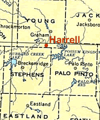
The Harrell site, located not far
from Graham, Texas, at the confluence of the Clear Fork
and main Brazos rivers, was investigated during a survey
of the area threatened by the construction of Possum
Kingdom Reservoir. Although the site was not inundated
by the lake, it has been eroded over time by natural
undercutting of the two rivers. Map courtesy of the
University of Texas Map Collection.
Click images to enlarge
|
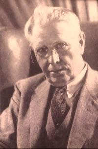
James E. Pearce, sometimes called
the father of Texas archeology, oversaw many of the
early Texas survey operations. Photo from TARL archives.
|
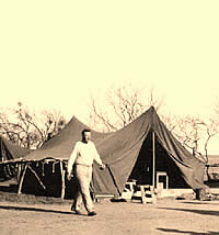
A small city of tents housed workers
during the six-months of investigations at the Harrell
site. Photo from TARL archives.
|
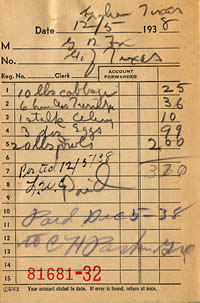
A
1938 grocery bill shows food purchases for the camp at
a time when a dozen eggs went for about $.33 and 20 pounds
of hog jowls for $2. Based on Fox's records, the weekly
menu showed little variation, with emphasis on root vegetables
and cabbage. Document from TARL Archives.
|
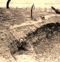
Burned rocks eroding out of a gully
bank proved to be a hearth and was uncovered further
in Excavation 2 operations. The Brazos river is visible
in the background. Photo from TARL archives.
|
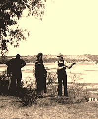
Visitors at the Harrell site. In
the background (view to northwest), the juncture of
the Clear Fork and Brazos rivers can be seen. Photo
from TARL archives.
|
An unknown man "stands sentry"
as a WPA crew member uncovers another hearth. Photo
from TARL Archives.
|
Field recorders drew a number of
the features in the field, such as this hearth, shown
in cross-section, found roughly 5 feet below surface
near the red clay stratum. Drawing from Fox, 1939; TARL
Archives.
|
The "Great Midden" had
at least three circular pits within the mass of fire-cracked
rock containing ashes and charcoal bits but few artifacts.
Shown is the "north firepit." Photo from TARL
archives.
|
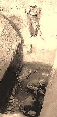
Constructed with stone slabs set
upright, this circular hearth had a layer of flat stones
at the base. During investigations, the hearth was "pedestalled,"
or isolated at its original level for further study
while the surrounding area was excavated. On the right
is one of several deep trenches dug to explore the site.
Photo from TARL archives.
|
This hearth was constructed mainly
of fragments of metates, or grinding slabs. Photo from
TARL archives.
|
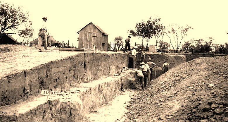
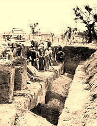
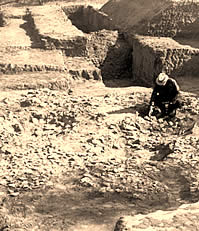
Workers uncover more burned rock
features at the bottom of a deep excavation unit. More
than 90,000 cubic feet of dirt was removed to explore
the Harrell site. Photo from TARL archives.
|
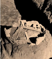
Examining burned rock features in
Excavation 1. Note the three basin-shaped, stone-lined
pits in front of the kneeling figure (an unknown investigator).
The masses of small limestone rocks surrounding the
pits are evidence of the oven "renewal" process-prehistoric
cooks had raked out spent burned stones after they became
too small and fragmentary to be useful in earth oven
cooking. Photo from TARL archives.
|
|