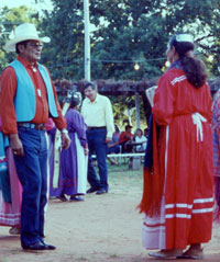
Summer dance at Caddo tribal dance
grounds, Binger, Oklahoma. Photograph courtesy Donna
Smith Spaulding.
Click images to enlarge
|
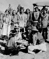
Caddo dance, 1892. Courtesy Marilyn
Murrow. Photograph from Archives and Manuscripts Division,
Oklahoma Historical Society.
|
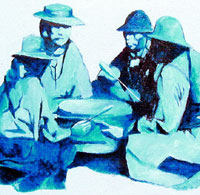
Caddo drummers seated at a dance.
This painting by Caddo artist Thompson Williams is based
on an 1892 photograph. Courtesy Senior Citizen Center,
Caddo Tribal Headquarters, Binger, Oklahoma.
|
|
Caddo communities were protected by the large size
of the Caddo territory, the Caddo's reputation as fierce
and skillful warriors, and their ability to band together
in times of crisis. Their neighbors near and far knew
not to enter Caddo territory without permission unless
they were looking for a fight.
|
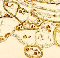
Map of Upper Nasoni settlement on
the Red River, produced by the Spanish expedition of
1691-1692, led by Terán del Rio. This village
was part of the Cadohadacho alliance. The map shows
that the community consisted of small farmsteads or
extended family compounds, each depicted as being surrounded
by rows of trees or bushes. On the left is a mound with
a "templo" on top. The settlement shown is
believed to have stretched along several miles of the
Red River. Original (uncolored) map in the Archivo General
de Indias, Seville.
|
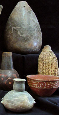
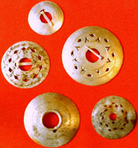
Ancient Caddo potters created an
extraordinary variety of pottery vessels from huge storage
jars over three feet high to tiny bowls probably made
for children. These examples are from the TARL collections.
Photograph by Sharon Mitchell.
|
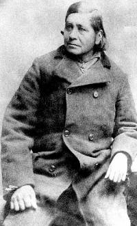
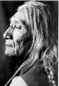
Whitebread, Caddo chief (caddi) from
1902-1913. Chief Whitebread, whose Caddo name translates
literally as "bread white," was a major source
of information on Caddo traditions for ethnographers
George Dorsey and John Swanton.
|
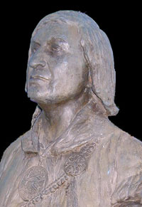
José Maria, famous chief of
the Anadarko (Nadaco), who rose to become principal
chief of all Caddo groups during the turbulent years
of the mid-1800s. José Maria, whose Caddo name
was Iesh
(Aasch), was famed both as a warrior and statesman.
It was he who led the Caddo from the short-lived Brazos
Reserve in Texas to the Indian Territory in 1859. This
bronze bust by sculptor Leonard McMurry is on display
at the National Hall of Fame for Famous American Indians
in Anadarko, Oklahoma.
|
Sho-We-Tit (Billy Thomas), a Caddo
man photographed by Joseph Dixon on June 21, 1913 at
Anadarko, Oklahoma. This extraordinary portrait was
taken on an expedition funded by Philadelphia businessman
and philanthropist Rodman Wanamaker. Dixon and his assistants
presented American flags to Indian tribes across the
country. The expedition was intended to promote loyalty
to the United States and document the "vanishing
Indian race." Courtesy William Mathers Museum,
Indiana University.
|
|
Today the Caddo Nation of Oklahoma has some
4,000 members on its official tribal roll. The tribal headquarters
is in Binger, Oklahoma, about 45 miles west of Oklahoma City.
It was here, in and around the towns of Anadarko, Binger,
and Fort Cobb, that the Caddo settled during and after the
Civil War. This final relocation was preceded by over a century
of turmoil during which Caddo groups were forced to give up
their home territories in northeast Texas, northwest Louisiana,
southwest Arkansas, and southeast Oklahoma.
Today's Caddo are the descendants of many distinct
communities of people who shared much of a common culture.
In the late 1600s and early 1700s, Spanish and French chroniclers
familiar with the Caddo homeland recorded the names of at
least 25 separate groups who spoke dialects of the language
known today as Caddo. Beyond speaking the same basic language,
these groups were linked by many shared customs, a similar
way of life, and by intermarriage.
Because of population loss and enemy encroachment,
most Caddo groups eventually organized themselves into the
Hasinai, Cadohadacho (also spelled Kadohadacho), and Natchitoches
alliances (often called "confederacies"). Group
consolidation took place in the Neches and Angelina river
valleys in east Texas (the Hasinai, comprised of the Hainia and other groups), the Great Bend area of
the Red River (the Cadohadacho), and in the vicinity of the
French post of Natchitoches, Louisiana. The Hasinai Caddo
continued to live through the 1830s in their traditional east
Texas homeland, while the Natchitoches did the same in western
Louisiana. But the Cadohadacho were forced to move west and south of
the Red River in the late 1780s, to the Caddo Lake area, along
the boundary between the U.S. territory of Louisiana and the
Mexican province of Texas. Some Cadohadacho stayed there until
about 1842, at the village of Sha'chahdinnih
or Timber Hill and several other poorly known villages.
When Europeans first arrived, the Caddo were
settled, farming people who grew corn, beans, squash, sunflowers,
and other crops and lived in farmsteads, hamlets, and villages
dispersed along streams and rivers that mainly flow to the
east and south through their homeland. Within this area the
forested Eastern Woodlands met the grasslands and savannas
that fringed the Great Plains farther to the west. Culturally,
the Caddo were the westernmost of the Indian societies of
the Southeastern United States, but their closest linguistic
and blood relatives were the Caddoan-speaking tribes of the
Southern and Central Plains: the Wichita, Kitsai, Pawnee,
and Arikara.
During the period from about 340 to 1000 years ago (A.D. 1000-1680), the Caddo, like
other Southeastern cultures, had "ranked" societies
with at least two social classes topped by the kin of the
hereditary religious and political leaders. Ethnologists sometimes
call such societies "theocratic chiefdoms" and recognize
that politics and religion were not separate domains but interwoven
parts of an intricate way of life. Although most Caddo communities
were scattered, and stretched out along river and stream valleys,
their most important leaders usually lived in or near the
larger villages and ritual centers
where towering temples built of poles and grass thatch stood
atop earthen mounds (see Teran map on left). At sacred
and festive times such as First Harvest and in times of crisis,
the scattered Caddo gathered where their society's leaders
lived.
The sprawling communities of the Caddo were
quite different from the compact fortified towns of other
societies along the central and lower Mississippi Valley,
a few days walk to the east. In 1541, the De Soto entrada
(intrusion) found fortified towns along the Mississippi River and
societies engaged in violent and habitual warfare. The Spanish
army sometimes attacked towns defended by well-organized warriors
and surrounded by stout log palisades and ditch works. But
as the Spanish moved farther west into the Caddo Homeland,
they came across open villages that were not fortified. Caddo
communities were protected by the large size of the Caddo
territory, the Caddo's reputation as fierce and skillful warriors,
and their ability to band together in times of crisis. Their
neighbors near and far knew not to enter Caddo territory without
permission unless they were looking for a fight.
Another thing that set the Caddo apart from
their neighbors was their extraordinary skill and creativity
as potters. Caddo women (and perhaps some men) made all kinds
of pottery from huge storage jars over three feet high to
tiny bowls smaller than a tea cup made for their children
as well as a variety of other objects including smoking pipes
and earspools. While much of the pottery was made for everyday
use in cooking, storage, and serving, the Caddo fine wares
also served other purposes (ritual and funerary) and are renown for their artistic craftsmanship.
Caddo potters were adept at combining flowing vessel forms
with polished surfaces that were characteristically decorated
with engraved designs. Other vessels had appliquéd,
brushed, incised, incisted-punctated or punctated designs, or were left plain. We know
that Caddo pots were valued by neighboring groups because
archeologists have found trade pieces hundreds of miles away
from the Caddo Homeland. In fact, it is the distinctiveness
of Caddo pottery that allows archeologists to trace, if imperfectly, much of
their early history.
The Caddo were also known as traders, famed
for their marvelous bows made of the wood of a tree the French
named bois d'arc ("bow wood," Osage orange)
and, their trade in salt. This trading
was an important part of Caddo life in the historic
era, as well as hundreds of years before European contact. The Caddo role as traders and, as information brokers,
was partly a consequence of the strategic position of their
territory between the Plains and the lower Mississippi Valley.
In the 17th century, the Spanish in northern Mexico learned
of the populous and prosperous Tejas Nation from the Jumano
Indians decades before Spanish expeditions reached the Caddo
homeland from the west in the 1680s. In the early 18th century French traders
were reportedly living in each of the major Caddo villages
along the Red River to take advantage of the Caddos' strategic
position and reputation as traders and middlemen. Soon large
quantities of deer and buffalo hides, horses and Apache slaves
from the Caddo and their trading partners to the west were
being exchanged for French guns and trade goods.
The name "Caddo" comes from Cadohadacho,
the name of one of the largest and most powerful groups in
early historic times, a people who lived mainly along the
Red River near its Great Bend. The Cadohadacho and their direct
ancestors had probably been living in the Red River valley for a thousand
years or more. "Cadohadacho" is often said to mean
"true chiefs" with the implication being that these
were the original Caddo, but this is a mistaken notion. (According
to linguist Wallace Chafe, the Caddo word, kaduhdááachu,
is a proper name whose full meaning and origin is lost; the
compound word contains a form of the adjective hadááchu,
meaning "sharp.") Other major Caddo groups have
equally long and distinguished histories, especially the Hasinai
groups who lived to the south in the Neches and Angelina
rivers basins in what is today east Texas. In fact, the Caddo groups
only became one people called the Caddo, after the mid-1800s,
when remnants of the many named groups united to save their
shared identity. Even today many Caddo people trace their
ancestry to one branch of the tribe or another.
Sorting out the various Caddo "branches"
is complicated and possible only to a limited degree. Over
the centuries prior to the arrival of Europeans, Caddo groups
had split apart from one another with "daughter"
communities breaking apart from "mother" communities
when moving into new territories in search of better farmland
and less crowding. The use of the terms mother and daughter
communities seems particularly appropriate because Caddo societies
traced their ancestry primarily through their mother's family.
In times of crisis, such as when enemies attacked, the most
closely related (and nearby) groups banded together into temporary
alliances identified with the strongest or principal social
group, which was often the older, mother community. The Cadohadacho
and Hasinai were the main groups who led the largest and most
influential alliances encountered by the Spanish and French,
while the Anadarko or Nadaco were another such unit. (These
are often misleadingly called "confederacies," a
term which implies a more formal union than was the case;
Caddo alliances were fluid and could be temporary.)
The 1942 map by ethnologist John Swanton shows
the approximate locations of some of the named groups/places
as recorded by the Spanish and French in the early 1700s.
Two principal alliances, the Cadohadacho and the Hasinai,
are shown as living in separate territories with a large intervening
area that appears to be unoccupied. This is, in part, a gap
of information rather than a complete absence of intervening
settlements. Swanton's map shows the areas known to the Europeans.
There is abundant archeological evidence that Caddo groups
were living in most parts of their traditional homeland in
the 16th and 17th centuries, but this settlement dispersion diminished after ca. A.D. 1680-1700. But by the time the Europeans
became familiar with the Caddo groups, many changes and consolidations
had already taken place as the result of the advance spread
of Old World diseases and the encroachment from the east and
north by opportunistic enemies such as the Osage and Chickasaw.
These developments impacted the easternmost Caddo groups first,
which explains why Swanton's map shows only the Cahinnio and
Ouachita villages to the east of the Red River.
|
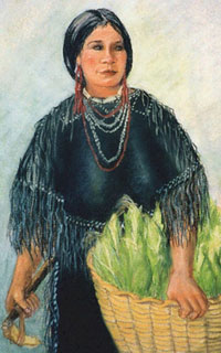
Artist's depiction of a Caddo woman
carrying a basket of freshly picked corn. Corn became
the Caddo's mainstay crop about 800 years ago and was
considered a sacred plant because of its importance
to Caddo life. Courtesy artist Reeda Peel.
|
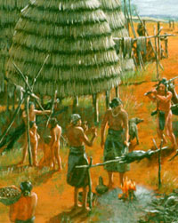
Artist's depiction of early Caddo
village, about 900 years ago. Painting by Nola Davis
on display at Caddo Mounds State Historic Park, Alto,
Texas. Courtesy Texas Parks and Wildlife Department.
|
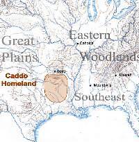
This map shows the relationship of
the Caddo Homeland to a few of the most important late
prehistoric civic and ritual centers that existed during
the heyday of the ancient Caddo, about 400-1000 years
ago (A.D. 1000-1600).
|
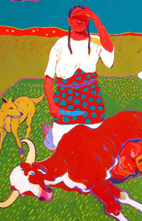
"Beef Issue at Fort Still"
painting by T.C. Cannon, son of a Kiowa father and a
Caddo mother. Courtesy of the Tee Cee Cannon Estate
and Joyce Cannon Yi, estate executor.
|
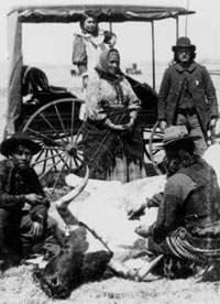
1894 photograph of Caddo family butchering
steer probably issued to family at the Anadarko Agency,
Oklahoma. Photo by Irwin and Mankins, from Archives
and Manuscripts Division, Oklahoma Historical Society.
|
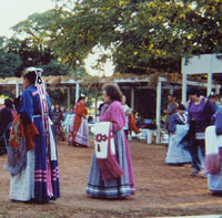
Dance underway at the Caddo Tribal
Dance Grounds, Binger, Oklahoma, 1995. Photo by Cecile
Carter.
|
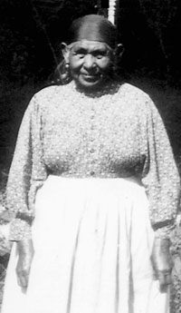
Mrs. Whitebread, wife of Caddo chief
(caddi), 1902-1913. Date of photograph unknown, probably
early 1900s. Courtesy Marilyn Murrow.
|
Heirloom silver broaches from Whitebread
family. Such pieces, typically made of German silver,
were worn around the turn of the century in much the
same way that conch shell artifacts were a thousand
years earlier. Photograph by Cecile Carter.
|
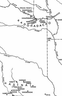
John Swanton's map showing the approximate
locations of some of the named Caddo groups and villages,
as recorded by the Spanish and French in the late 1600s
and early 1700s. From: Source Material on the History
and Ethnology of the Caddo Indians, 1942, Smithsonian
Institution.
|
|