The Landis Project:
Traces of Early Campers on the Texas High Plains
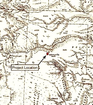
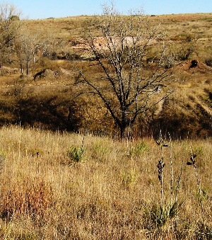
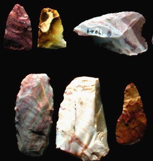
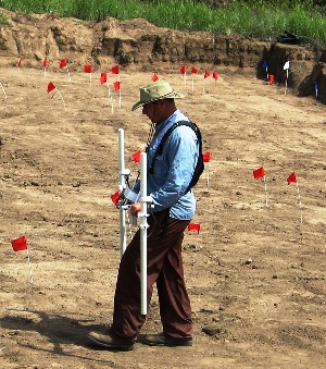
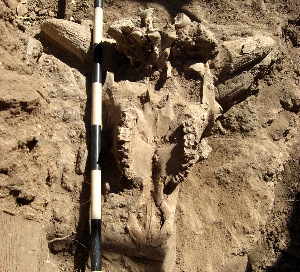
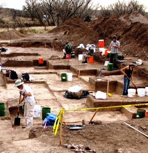
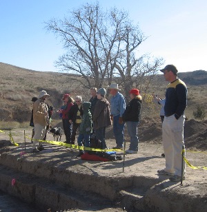
Throughout prehistory and well into the time of European explorers, Native Americans camped along the wooded, spring-fed streams draining into the Canadian River in the northern Texas Panhandle plains. Except for these erosional valleys, fittingly known as breaks, and the occasional playa depressions, the land surrounding extends into the horizon as a vast, treeless tableland. This mix of terrains—grassy prairies cut by wooded riverine valleys—offered good habitat for a variety of animals, and the hunters who preyed upon them. In the rocky outcrops of this High Plains setting, Native hunters also found another critical resource—high-quality stone, including brilliantly colored Alibates flint and Tecovas jasper—to use in crafting their weapons and tools. In 2007, archeologists from TRC Environmental Corporation began extensive excavations at sites previously identified on the Landis property in a stream valley just west of Amarillo, Texas. Work was carried out on lands previously owned by the Bureau of Land Management (BLM), the agency that funded this project and sponsored this educational exhibit. The archeological investigations were necessary as the BLM transferred the land from government to private ownership, in this case from BLM management to the Girl Scouts of America. During the course of their investigations, archeologists uncovered major campsites dating to two different cultural periods of the last 2,500 years in low creek-side terraces along West Amarillo Creek. Both of these sites are extremely significant. Only a handful of sites from these time periods have been intensively investigated and reported upon in the Panhandle region and its bordering states. Both have yielded new findings presented in this exhibit, including use of Canadian wildrye grass seed, along with heavy reliance on bison, for food. At the older campsite, known as the Pipeline site, evidence of two camping events during the Late Archaic period was uncovered. At these campsites, archeologists found areas of bison butchering, and evidence of plant processing and cooking. A variety of chipped-stone tools, including a rare corner-tang biface, were made of high quality local materials. Corner-notched dart points from the site are somewhat different from others found in the region and may reflect specific Late Archaic groups who made this particular style of points. The younger campsite, known as the Corral site, dates to some 200 to 300 years ago, during the Protohistoric Period. During this time, Native American groups became increasingly mobile as European explorers and expeditions entered the Southern Plains. At this deeply buried but largely intact, short-term campsite, archeologists found distinct areas where the Native peoples processed and cooked bison and plant foods, knapped tools, and buried a cache of chipped-stone scrapers. This cache is particularly intriguing, given that Native peoples at this time had begun trading with Europeans and replacing traditional stone tools with metal tools and knives. A small brass "tinkler" and a few other pieces of metal are the only hints of this newly available resource—and the cultural upheaval that lay ahead for the region's Native inhabitants. Investigative ApproachesDuring investigations at the Landis Property, large excavation blocks were dug in targeted areas where subsurface anomalies had been identified or cultural materials previously detected though geophysical survey and testing. These broad horizontal exposures helped archeologists see patterning in artifact and feature distributions, such as areas where tools were knapped or foods cooked. Geoarcheological excavations included the mechanical excavation of 47 backhoe trenches to determine the type, nature, and age of the deposits encompassing the cultural artifacts. Analyses included determining grain size of sediments, the amount of organic carbon and calcium carbonate, magnetic susceptibility, stable carbon isotopes, and conducting radiocarbon dating. Together, these data provided a complex alluvial history spanning a large part of the Holocene period and helped archeologists understand the natural depositional processes in the West Amarillo Creek area. Laboratory analysts conducted an array of specialized technical analyses including extensive studies on burned rock and stone tools. A significant finding was the detection of starch grains and gelatinized starch residues on stone tools and burned rock, enabling a reconstruction of the processing and cooking of Canadian wildrye (Elymus canadensis) grass seed and other foods. Use-wear analysis detected unusual hafting patterns on many of the tools and helped establish how the tools may have been used. Other chipped-stone materials were subjected to neutron activation analysis, through which the probable source areas for the toolstone—including Alibates "flint" (or silicified dolomite), Tecovas jasper, and obsidian—was traced. During the project, TRC archeologists also hosted several educational open houses for area Girl Scouts and their families. These hands-on experiences enabled the Scouts to more fully appreciate the cultural history of the land and the scientific processes involved in reconstructing the past. Natural SettingThe Amarillo region is part of the Southern High Plains located at the very northern end of the Llano Estacado, in what is referred to as the Canadian Breaks. The broader region is characterized by a flat, low relief surface dotted with small playa-lake basins which periodically hold water following rains. The Canadian River and its many short tributaries create a major topographic relief in the Texas Panhandle. West Amarillo Creek, one of the many streams that flow north into the river, extends roughly 15 miles with several smaller branches. Roughly half a mile wide in the vicinity of the Landis property, this stream valley forms a relatively deep draw, with mostly steep-sided valley walls and rock outcrops near the valley rim. Near the investigated sites, the creek bed is about 100 feet below the valley rim. Springs that originate in the Ogallala Formation are the primary source of water flowing through the valley. Over the last decade, the Ogallala Aquifer across the Llano Estacado and High Plains has been lowered more than 25 feet (8 km). The modern city of Amarillo lies on the northern margin of the Llano Estacado, near the divide between the Canadian River to the north and the headwaters of the Red River to the south. On the Landis property, a botanical inventory identified more than 60 species of plants including 15 different grasses and at least 8 species of trees. Eighty-one percent of the grasses are warm season C4 species. In general, the hillsides support shortgrass prairie dominated by various grama and little bluestem grasses, plus mesquite, sagebrush, halfshrub sundrop, yucca, skunkbrush sumac, and hackberry. In more moist canyons, willows and cottonwoods, grape, and goldenrod prevail. The open prairies adjacent to the valley are classified as grama-buffalo grass, reflecting the dominance of those two species. Encroaching on this grassland are thorny mesquite, an invader species, along with stands of prickly pear and cholla. This primary floral community extends off the High Plains and into the creek valleys. On stream terraces next to creeks, mesquite-bristlegrass covers nearly half the ground with skunkbrush scattered along the steep mesa slopes. Hackberry is often found with large cottonwood along the streambeds. In some areas, juniper is randomly interspersed within the mesquite grassland, predominating in some locales in the region. The plant communities present today may not be similar to past vegetation communities. As shown in the Paleoenviroment section, changes in climate and ground water availability may have altered their composition through time. In This ExhibitIn the following sections, we trace archeological and geomorphological findings from the Landis project. Reconstructing the Paleoenvironment draws together data derived from along West Amarillo Creek enabling reconstruction of environments from the last 2,000 years. Late Archaic groups left their mark on at least two occasions at the Pipeline site: the campers knapped stone tools and processed and cooked bison and wildrye grass seed. Evidence from the Corral Site provides a rare glimpse of Native peoples during the Protohistoric period some 200-300 years ago. Highlights and Future Research draws together key findings from the project. Public Archeology showcases open-house events held during the project to offer visitors a close-up look at archeologists at work. The Credits and Sources section acknowledges participants and sponsors of the project and provides a list of resources for further learning.
|
|