Texas Beyond History
TBH Home
Frontier Forts Main

The Painted Comanche Camp

Ft. Davis
Stretching across the mouth of a mountain canyon, a row of officers' quarters at Fort Davis reflects an early fall sunrise. Photo by Susan Dial.
rock art
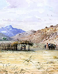
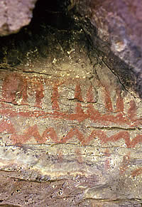
Indian pictographs in Limpia Canyon, Davis Mountains. Although soldiers at Fort Davis observed aboriginal drawings on the trunks of cottonwood trees along Limpia Creek, paintings such as the one above were rendered on canyon walls and in rockshelters, a natural canvas for artists. The name given an early Army encampment in the canyon, "Painted Comanche Camp," no doubt derived from such artwork. Photo from TARL Archives (JD7, #C-2).
Ft. Davis map
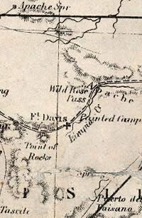
As shown on this 1861 map, Fort Davis was sited on Limpia Creek near the mouth of Wild Rose Pass. Note reference to Painted Camp just east of the post. Inset of Richardson's New Map of the State of Texas, courtesy the David Rumsey Map Collection.
barracks
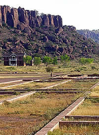
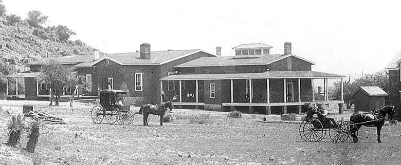
Low foundation footings are all that remain of some of the enlisted men's barracks constructed in the mid 1870s. In the distance is a two-story shared officers' quarters, with the foundations of the post headquarters building on left. Photo by Susan Dial.
Indians viewing newspapers
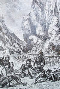
"Indians Surprised in Limpia Canyon" reads the title of this intriguing drawing from the published accounts of a Butterfield stage traveler in the 1850s. Following an attack on the Jackass Mail, Indians discovered a packet of illustrated newspapers, which they reportedly found absorbing. The sudden appearance of soldiers on the scene led the Indians to ascribe magical powers to the newspapers. Drawing courtesy National Park Service: Fort Davis National Historic Site, Texas.
porch at the Commanding Officer's Quarters
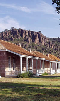
Morning sun streams over a wide porch in front of the Commanding Officer's Quarters. Photo by Susan Dial.

The Davis Mountains are an almost lush, alpine oasis rising from the surrounding desert. Nearly out of view from modern Interstate Highway 10, these peaks may escape the notice of westbound travelers impatient to reach El Paso, 200 miles away. But the U.S. Army engineers who passed through the Trans-Pecos in 1849 took careful note of what they found here.

Lieutenants W.H.C. Whiting and William F. Smith had been sent from San Antonio to find a practicable wagon route west. After several days spent looking for drinkable water west of the Pecos River, Whiting must have felt a great sense of relief upon finding a small stream in a mountain canyon. His reaction to the discovery was almost lyrical: he named the little brook the "Limpia," while a two-mile passage among the mountains became "Wild Rose Pass." His party's resting place was "Painted Comanche Camp," so named because of pictographs that adorned nearby cottonwood trees.

Whiting and Smith ultimately recommended that the army build a road through the pass, in what would be known for a time as the Limpia Mountains. It became the army's preferred route through the Trans-Pecos, and hundreds of emigrants bound for the California gold fields were soon traveling it. In 1851, frontiersman Henry Skillman began using the road for his mail service between San Antonio and Santa Fe.

Travel in the Trans-Pecos was dangerous. Mescalero Apaches inhabited the mountains through which the road passed. Comanche and Kiowa raiders sweeping down from the High Plains crossed the road on their way to their favorite raiding targets in northern Mexico. By mid-1854, it was plain that the army needed posts to protect the route.

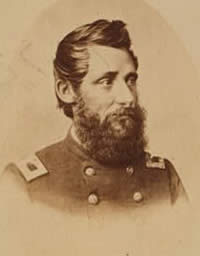
General Persifor F. Smith, departmental commander, set out from San Antonio in September to look into the problem 
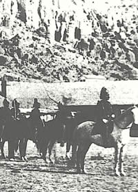
and find a site for a post. Smith stopped at the Painted Comanche Camp, where he was joined by Lieutenant Colonel Washington Seawell and the six companies of the 8th Infantry that would garrison the new installation. It was to be called Fort Davis, in honor of the United States secretary of war, Jefferson Davis. General Smith personally selected the location for the fort, a spot about a quarter of a mile from the camp, surrounded on three sides by the sheer rock cliffs of a canyon.

A stand of timber was found in the mountains about 25 miles from away, and Sewell soon had the soldiers hauling logs and cutting planks for living quarters and other buildings. Six shelters, one for each company, were erected across the mouth of the canyon. They were made of oak and cottonwood pickets and measured 20 feet wide and 56 feet long.

Within two years, these were converted to kitchens and mess rooms. New stone barracks with thatched roofs were erected to the east, in a line parallel with the original structures. Other stone buildings were a bakehouse, blacksmith shop, and warehouse. Additional structures were built further up the canyon to the west. These were made of wood planks, set into the earth on end, picket style, with plank or earthen floors and thatched grass or canvas roofs. They included 11 
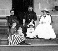
sets of officers' quarters and a two-room house for the commanding officer. A hospital, adjutant's office, housing for married soldiers and their families, storehouses, a stable, a sawmill, and a sutler's store made Fort Davis one of the army's most extensive western posts.

The San Antonio-El Paso mail enterprise was being reorganized even as General Smith was issuing his order for establishment of Fort Davis. Skillman and George Giddings entered into a partnership to provide mail and passenger service, and constructed "La Limpia Station" a mile from the army encampment. This provided the stage drivers a place to obtain a fresh team of mules, the line's first relief station west of the Pecos River.

Additional stations were established at Live Oak Creek, where the army placed Fort Lancaster in 1855; in Quitman Canyon, where Fort Quitman was established in 1858; and at Comanche Springs, where the army began erecting Fort Stockton in 1859. Intermediate stations were built between the various army posts throughout the 1850s.

The availability of replacement mules made it possible for the coaches to travel the road more quickly and more frequently, but the relief stations and their corrals also were magnets for Apaches and Comanches. The army could provide little protection, and Skillman and Giddings experienced a disastrous year in 1858. In January, La Limpia was raided and all its stock was stolen, and the El Muerto and Van Horn's Wells stations were both destroyed. Raids on Comanche Springs and Lancaster, and another on La Limpia, followed during the spring. The stations at Escondido Springs and Eagle Springs were destroyed in the fall. In 1859, the Trans-Pecos stations suffered 10 more similar attacks.

Wild Rose pass
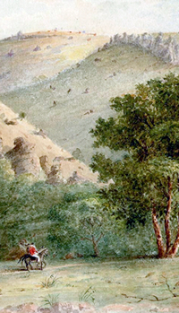
The beauty of a two-mile passageway through the Limpia mountains inspired Army road engineer Lt. W.H.C. Whiting to name it Wild Rose Pass. The scene above was painted by Capt. Arthur T. Lee, another admirer of the area's scenery. Click to see full image. "In Wild Rose Pass," courtesy of the Rochester Historical Society.

Click images to enlarge

"Maggie's Kitchen"
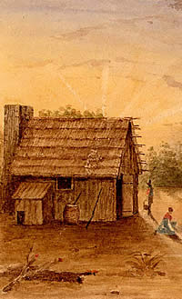
The first buildings at the fort were constructed of wood, using timber hauled from as far as 25 miles away. When more permanent structures of stone were built two years later, the earlier, crude buildings were converted to kitchens and mess rooms. "In Maggie's Kitchen," by Capt. Arthur T. Lee, courtesy of the Rochester Historical Society.
interior of barracks
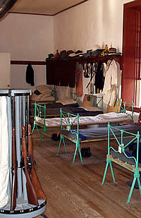
With bunks made up and cavalry carbines stacked, this enlisted men's barracks appears much like it would have in the past. It was among the first buildings to be constructed after the Army reestablished Fort Davis in the late 1860s. Photo by Susan Dial.
cottonwoods
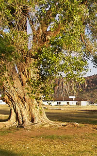
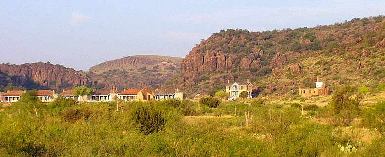
Cottonwoods flank a distant view of the fort. The white buildings on left are enlisted men's barracks, beyond them, officers' row. Photo by Susan Dial.
Jr. officer's quarters
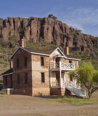
Constructed at the base of a rugged cliff in 1885, this two-story shared quarters was often occupied by junior officers. Photo by Susan Dial.
stage coach leaving Ft. Davis
With a small escort of soldiers to offer protection, a stage coach departs Fort Davis. Travel in the Trans-Pecos was hazardous, with stage lines a frequent target of attack by Indians. "Fort Davis" by Melvin Warren, courtesy of Mrs. Melvin Warren. View full image.
overland mail station
An overland mail station, no doubt typical of dozens established across the Trans-Pecos. Situated roughly 20 miles apart, the stage stops offered food, water, fresh teams, and protection from Indians and bandits. Detail of painting by Capt. Arthur T. Lee, courtesy of Rochester Historical Society.
Pinery Station
Ruins of the Pinery Station, a Butterfield Overland Mail stage stop, in the Guadalupe mountains northwest of Fort Davis. Named for the piñon pine trees growing nearby, the Pinery was only in operation from 1858 to 1859 before the stage line was rerouted to Fort Davis and the protection it afforded. Photo by Susan Dial.
officer's row
Wide front porches on the quarters along officers' row encouraged socializing among the post families. Photo by Susan Dial.
Benjamin Grierson
Unlikely warrior Benjamin Grierson was a music teacher and merchant from Illinois who, as a child, had been kicked in the head and nearly killed by a horse. Regardless, he went on to distinguish himself as a cavalry commander, both in the Civil War and Indian Wars. Photo, circa 1863-1864, courtesy Library of Congress.

At the beginning of the Civil War, the army abandoned Fort Davis and the other Texas posts. A Confederate invasion force bound for New Mexico passed by the post, and one company of the 2nd Texas Mounted Rifles under Lieutenant Reuben E. Mays was left there as a garrison. In August, 1861, the Mescalero chief Nicholas led a raid on the fort. Mays and 14 other Confederate soldiers pursued the Indians into the Big Bend country and died in an ambush. Only the party's Mexican guide escaped.

After the New Mexico expedition was repulsed, Confederate forces withdrew from western Texas. A Federal cavalry detachment visited Fort Davis in August, 1862, found most of the buildings in disrepair, and left the next day. The remains of the post lay empty for the next five years.

The end of the Civil War brought renewed activity to the Trans-Pecos. Re-opening of stagecoach operations between San Antonio and El Paso, and the advent of cattle trailing from Texas to New Mexico by way of the Pecos River, drew the U.S. Army back to Fort Davis. Four companies of the 9th Cavalry commanded by Lieutenant Colonel Wesley Merritt rode into the battered post in June, 1867. Merritt immediately began a significant rebuilding project, and employed some 200 civilian carpenters, masons, and semi-skilled laborers for the task.

Merritt relocated the heart of the fort outside the canyon, on a plain below the mountains. Two years of construction work resulted in new officers' quarters and enlisted men's barracks. In 1869, the departmental quartermaster ordered construction halted, and additional work was done only sporadically through the 1870s.

Lieutenant Colonel William R. Shafter, 24th Infantry, took command at Fort Davis in May, 1871. "Pecos Bill" was known equally well for his excessive weight and surprising energy, and in June he turned what could have been an unremarkable pursuit into a three-week expedition through the trackless Monahans Sand Hills and other unexplored parts of the northern Trans-Pecos. In October, he led two companies of the 9th Cavalry and one of the 25th Infantry on a similar sweep of the desert and mountains of what today is Big Bend National Park.

The principal Mescalero bands went onto the Fort Stanton, New Mexico, reservation in September, 1871. Apart from a flare-up of Indian raiding in 1873, the Trans-Pecos was comparatively quiet during the mid-1870s, but hostilities intensified by the end of the decade. The Mescalero became restive on their reservation, and some escaped to the Guadalupe Mountains or the Big Bend. Others used the reservation as a sanctuary to raid in New Mexico, Mexico, and Texas.

The army responded by focusing special attention on the Trans-Pecos. General Edward O.C. Ord, commanding the Department of Texas, created a new District of the Pecos under Colonel Benjamin H. Grierson, who at the time had his 10th Cavalry headquarters at Fort Concho. With his "buffalo soldiers," and their 24th and 25th Infantry brethren, Grierson embarked on a two-year campaign against the Apaches. He established two sub-posts of Fort Concho, two of Fort Stockton, and three of Fort Davis. The Fort Davis sub-posts were at Seven Springs, the stagecoach station at Eagle Springs, and John Butterfield's abandoned Overland Mail station at Pine Springs in the Guadalupe Mountains.

The effort came none too soon. Indians killed 14 persons in the District of the Pecos during the first six months of 1878, and in August attacked the El Muerto stagecoach station, killed a driver, and stole all of the station's livestock. Grierson's troopers scoured the Trans-Pecos. The three 10th Cavalry companies stationed at Fort Davis logged 6,742 scouting miles in 1878, the most for any post in the Department of Texas that year.

Wesley Merritt
A youthful Wesley Merritt shown ca. 1860-1865 in his Civil War period uniform. From 1867 to 1869, Merritt supervised the rebuilding of Fort Davis as a lieutenant colonel of the 9th Cavalry. Photo courtesy Library of Congress.
Pinery Marker
Marker for the 1850s stage coach stop known as the Pinery. The Overland Mail station, abandoned in 1859, was used as a 10th Cavalry subpost during the Army's 1879-1880 campaign against the Apache leader Victorio. Photo by Susan Dial.
parade
Troop I of the 9th U.S. Cavalry "on parade" at Fort Davis, circa 1875. Photo courtesy National Park Service: Fort Davis National Historic Site.
parlor
Comforts of home on the frontier. The parlor of Col. Benjamin Grierson shows the influence of his wife, Alice, who, like many other officers' wives, insisted on bringing crate loads of furnishings to make the stay on the frontier more pleasant. Photo by Susan Dial.
"Tracking Victorio"
The Army spent months tracking the elusive Apache leader Victorio through the mountains of the Trans-Pecos. Col. Benjamin Grierson assigned eight companies of the 10th Cavalry to the search which resulted in several battles with the Apaches. Victorio and his band retreated across the Rio Grande where most of them were killed by Mexican troops. "Tracking Victorio" by Don Stivers.
Victorio
Apache leader Victorio led raids throughout the Trans-Pecos.
Loco
Loco, a Warm Springs Apache chief, circa 1884. Photo courtesy the Denver Public Library, Western History Collection (#X-32910).

A brief period of relative calm was broken in August, 1879, when the Warm Springs Apache leader Victorio and some followers fled the Mescalero reservation near Fort Stanton. Victorio and the Warm Springs Apache had left the San Carlos, Arizona, reservation in 1877 and had alternately raided and relented, before agreeing to settle at Fort Stanton. Victorio's last break-out was the beginning of the army's last Indian campaign in Texas.

In September, 1879, Victorio's band attacked a company of the 9th Cavalry in New Mexico, killed or wounded eight troopers, and escaped with 46 horses. The Apaches killed nine civilians in the next week, and spent most of the next nine months in deadly raids on civilians on both sides of the Mexican border and in skirmishes with the U.S.Army in New Mexico. While the 9th Cavalry chased Victorio through western New Mexico, Grierson took five companies of the 10th Cavalry and a detachment of 25th Infantry to help disarm the Fort Stanton Mescaleros in April, 1880.

After having returned to Texas—and believing that Victorio was headed there as well—Grierson concentrated eight companies of the 10th Cavalry at Fort Davis, where they joined four companies of the 24th Infantry. He then spread his forces among the water holes and mountain passes of the Trans-Pecos, and headed to the theater of action himself.

Grierson and a small cavalry detachment intercepted Victorio's band at a water hole called Tinaja de las Palmas. Three companies of reinforcements helped turn back the Apaches after a four-hour battle. Seven days later, Grierson and four companies of the 10th Cavalry blocked Victorio's access to the water at Rattlesnake Springs. After retiring to the mountains, the Apaches attacked an approaching army supply train, but were driven back by a company of the 24th Infantry and a detachment of cavalry.

In the interval between the battles at Tinaja de las Palmas and Rattlesnake Springs, another 10th Cavalry detatchment attacked the Apaches' supply camp and destroyed most of their provisions. Denied passage through Texas and low on food and water, Victorio withdrew across the Rio Grande to find refuge in Mexico. Although he had used the Chihuahuan mountains as a lair for years, Victorio survived only two more months before being cornered by Mexican soldiers who killed him and most of his band.

The army did not mount another major campaign against Indians in Texas, but Fort Davis would continue to represent a major investment throughout the 1880s. Grierson moved his headquarters there in 1882, and he supervised a program of expansion and improvement of the physical facilities during the three years he and the 10th Cavalry remained.

Although he had used the Chihuahuan mountains as a lair for years, Victorio survived only two more months before being cornered by Mexican soldiers who killed him and most of his band.

US Cavalry
Troop C, 3rd U.S. Cavalry, posing on rocks behind Fort Davis. Photo, circa 1886-1887, courtesy of the National Park Service: Fort Davis National Historic Site.
Ft. Davis hospital
The post hospital, shown from rear, in late 1880s after additional construction increased capacity. With renovation and the addition of a second ward, the hospital was considered one of the most up to date medical facilities west of San Antonio. Photo courtesy National Park Service: Fort Davis National Historic Site.
 

The capacity of the new post hospital, built during the period 1874-1875, was increased in the 1880s by the addition of a second ward. New stone and adobe officers' quarters, cavalry barracks, infantry barracks and band barracks were other additions. An ice plant, a water system, and gas street lamps provided amenities.

The army abandoned Fort Davis in 1891, and the property reverted to civilian ownership. In 1906, the land and remaining buildings that had comprised the post were turned over to the United States Department of the Interior. In 1961, the post was authorized a national historic site, and in 1963 it was open to the public. Today, the site features more than two dozen restored buildings and ruins of many more.


John Lauderdale and family
Post surgeon John Lauderdale and his family at Fort Davis in the late 1880s. Lauderdale came to Fort Davis from Fort Clark, after most of the fighting in the Trans-Pecos had ceased. Based on Lauderdale's accounts, he spent much of his time supervising the making of ice and treating soldiers suffering chiefly from "too free use of alcohol." Photo courtesy the National Park Service: Fort Davis National Historic Site.