| |
| |
| |
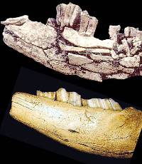
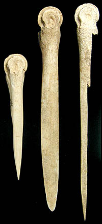
Two deer mandible (jaw bone) sickles
used to cut grass for roof thatch and other uses. The
fragmented and weathered one at the top was found just
outside the Kit Courson house in the work area. You
can see the characteristic sickle-sheen caused by the
build up of grass silica and polish on the better preserved
one (bottom) from Courson B. (You are looking at the
interior (inside view) of the top mandible and the exterior
of the bottom mandible.) Photos by David Hughes and
Steve Black.
|
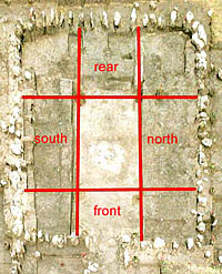
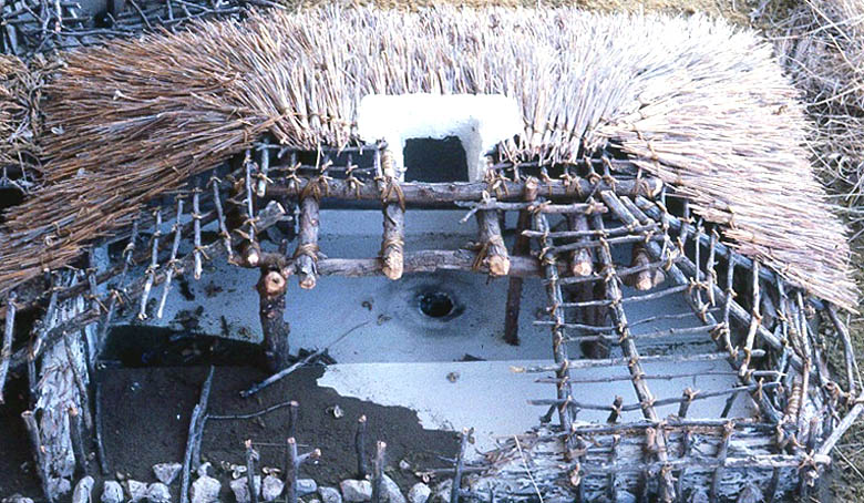
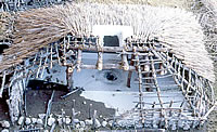
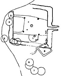
Dividing the interior of the Kit
Courson house into third's along both axes makes it
easier to talk about how each part of the house was
used. Photo and graphic by David Hughes.
|
Buffalo rib pot stirrer? This bison
rib found on the floor of the central channel of the
Kit Courson house is worn on its edges and especially
at its tip. This abrasive wear pattern is consistent
with the interpretation. Photo by David Hughes.
|
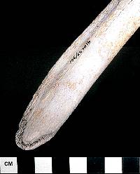
Bone awls used for leatherworking
or basket-weaving found in a U-shaped channel at the
rear of the Courson B house. These are made from deer
metapodial (ankle) bones and have smoothed and polished
tips from wear. Photo by Steve Black.
|
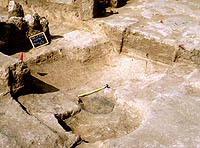
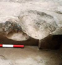
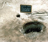
This circular pit and central hearth
are all that remains of a scooped-out pithouse found
beneath Courson B, a large, typical stone-based Buried
City house. The pithouse was small—only about 2.5
meters (8 feet) across. Photo by David Hughes.
|
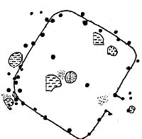
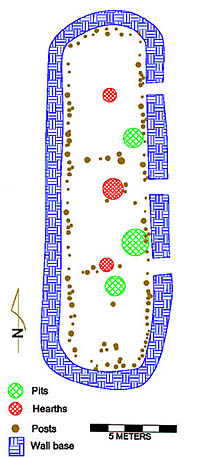
Map of small, post-lined house with
central firepit and two central support posts known
as Courson A. The inferred outline of the house is shown
as a solid line. Graphic by David Hughes. Click to see
enlarged view with more details.
|
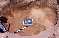
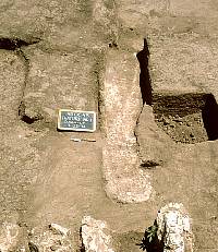
Large storage or "cache"
pit associated with the Courson A house. These cylindrical
pits were probably used for storing corn and were later
filled with trash. Most such pits at Buried City are
smaller, about a meter in diameter. Photo by David Hughes.
|
Inferred configuration of Eyerly's
Temple based mainly on recent excavations. This structure
has been dug into repeatedly since 1906, mainly by
curiosity seekers. As a result, much of the critical
evidence within and around the stone wall foundations
has been destroyed. Graphic by David Hughes.
|
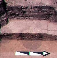
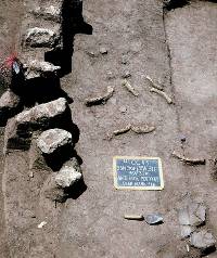
Two overlapping hearths as cross-sectioned
by excavation in the southern half of the "Temple"
. The lower, cylindrical firepit (left) dates to the
main Temple occupation. The intruding basin-shaped pit
hearth (right) is part of a later occupational episode.
Photo by David Hughes.
|
|
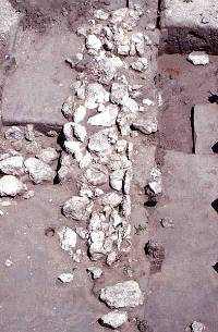
Dark circular stains of postmolds
from large wall posts exposed inside the west wall of
the Temple by the 1988 TAS Field School. These were
found well within the room and perhaps served as roof
support posts. View looking west. Photo by David Hughes.
|
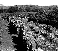 Figure 32 from Moorehead's 1931 report. It is labeled
as "west wall of Gould Ruin." A second photo
(Moorehead's Figure 34) is labeled "east wall of
Gould Ruin," but both photos show the same wall.
Click to see comparison. |
|
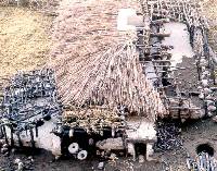
Life in the Kit Courson House
The Kit Courson house is the most thoroughly
investigated Buried City house. A detailed model of the house
was built by Danny Witt based on archeological documentation
and comparative data from historic earth lodges in the Northern
Plains. Although the Buried City houses may have had grass-thatch
roofs instead of being earth-covered and differed from Plains
earth lodges in other important details, the basic layout
and roof-framing may have been similar. Putting it all together—documented
details and supposition—we offer a sketch of life in the
Kit Courson house (drawing on details from other Buried City
houses as well).
The villagers would have entered the house from the east via an extended
entryway (slightly sloping down into the house), possibly
a crawl-way that was lined with posts and covered like the
house roof. The narrow entranceway minimized the amount of
snow and cold air that entered the house. Near the entrance,
but outside the house was a smaller, perhaps semi-attached
room on the southeast corner that had apparently been
added after the main house was built. This added room may
have served special purposes such as that of a menstrual room
or perhaps a mother-in-law's room. The houses of several Plains
Indian groups are known to have had such features.
Between the entryway and the attached room was
a food processing and work area where in good weather
people would have performed routine tasks like food preparation,
tool maintenance and repair, and other daily functions. (In this
area, archeologists found many deer-antler tool handles and flint-knapping
tools, a deer-jaw sickle for cutting grass, grinding stones,
and large fragments of pottery.) Weather permitting, most daily
activities and work probably took place outside the house.
When the north wind was blowing, outside work likely was done on the
leeward (protected) side of the structure or in sheltered nooks like that
created by the room addition and the entryway wall.
Entering the house, you would have stepped
over a small raised sill at the bottom of the entranceway.
When inside the house, proper, you would have been standing
in the central channel, the lowest floor level. The
sill you stepped over may have served two purposes; it probably
keep water from seeping into the room from the entranceway
and it would have been a stop for an entryway flap
door, probably made of bison hide. Such a flap door would
have been needed in the winter to trap cold air and keep it
from entering the room. Interestingly, just inside several
houses in the southeast corner of central channel, we have
found several smooth rounded stones, sometimes fragments of
grinding stones. Jack Hughes thought these served as weights
for the entryway flap door.
In the center of the central channel (which
is also the center of the house) was a fireplace or
hearth confined within a raised ring of plaster. Smoke from
fires would have exited through a hole in the roof that was
probably lined with plaster to guard against an accidental
fire (a grass-thatched roof would have been highly flammable).
Not surprisingly, numerous charcoal flecks are found in the
center of the houses surrounding the fireplace, often embedded
into the plaster. Other cooking-related detritus found in
this area includes many small (½-inch diameter or so)
fragments of pottery and small scraps of bone or mussel shell.
In the center of the channel, south of the firepit in one
house, we found a mid-portion of a buffalo rib lying against
the bench margin. The rib was worn in such a way as to suggest
it may have been used as a pot stirrer in food preparation.
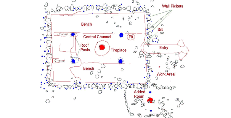
Surrounding the central channel area are wide,
low, elevated platforms or benches occupying the north
and south thirds of the room and a narrower rear bench occupying
the western one-third. At the intersection of all these thirds
are the four massive posts, buried as much as 60 to 75 cm
below the lowest surface of the living floor.
In the front section of the house, the south
bench and adjacent channel area was apparently an interior
work area. At several other Buried City houses, we have found
flint-knapping debris, broken grinding stones, and heavy compaction
and wear on the floor. Most of the debris is in the central
channel, although evidence of flint knapping occurs on the
bench itself. In the Kit Courson house we found the sharp
end of a flint knife embedded in the floor—it looked
like someone had plunged a knife into the floor and then snapped
it off, leaving the broken end just below the plaster surface
of the floor in this area. In the central channel adjacent
was a large quantity of knapping debris from the same kind
and color of chert.
The front part of the north bench was
consistently cleaner than the south bench but also had some
minor knapping and bone debris (small fragments ½ to
2 inches long, possibly from meal leftovers or bone tool manufacture).
On the surface of the front-north bench areas we found fragments
of charred food items, in one instance a small pit, possibly
a storage pit, and occasional bits of pottery and tips of
bone awls.
In contrast to the front bench sections, the
central bench sections on either side of the hearth
near the center of the house are normally clean and artifact-free.
In the houses where plaster is preserved, it is heavily worn
in the central bench sections, suggesting much traffic. This
is probably where people sat while cooking and eating and
through which they passed when heading to the rear bench corners.
The rear benches, sometimes had greasy
or burned areas about 50 centimeters (20 inches) in diameter.
This could be where small warming fires (or perhaps hot stones)
were placed or perhaps the rotted remnants of a buffalo robe pile?
This pattern was very obvious at the Courson B House. In general,
the rear north and south benches (corner sections)
of Buried City houses have never produced any artifacts on
the plastered floor, and the plaster is normally well maintained
with little or no wear. These corner sections are separated
from the central rear bench by a shallow U-shaped
channel that runs along the north and south margins of
the rear bench and slopes from near the floor surface at the
west end down to the level of the central channel abutting
the main support post at that point. At the Courson B house
we found unusually complete deer metapodial (ankle bone) awls, or weaving
tools, in the channel that separates the rear bench from the
north and south benches. It is not known whether these channels
served a mundane function, such as ventilation
channels leading to small holes in the outside wall (possible
indication of such was found in one house.) Alternatively,
they could be dividers that set aside the central rear bench
area as sacred space, where ritual paraphernalia was kept.
The pattern designating the central west/rear section of houses
as sacred space (often used for altars) was widespread among
Plains Village groups.
Architectural Variation
So far we've described only a single
kind of house at Wolf Creek. These are the large, stone-based
houses of about 64 square meters (689 square feet) enclosing
a large single room that can be divided into several discrete
areas based on apparent structural features (benches, channels,
posts, etc.). Such houses are found in isolated locations,
well separated from one another, and were probably built adjacent
to one or more garden plots. These are the houses that most
observers have noted and dug into, mainly because they are
large and obvious. They appear to date in the middle to late
14th century A.D. and are limited to a few miles along Wolf
Creek, primarily on the south side of the creek.
Other styles of structures have been identified
during our studies and by the ongoing work by the University
of Oklahoma. Four different house styles have been identified
so far: single-post-wall structures, pit-houses or houses
in pits, large single-room stone foundation houses, and one
extremely large, multi-roomed, stone-based house. Design variation
in the houses in a community is accepted as the norm
today, yet archeologists seem to assume that, in the past,
people made all their buildings in the same way in each area.
Much of the variation we see along Wolf Creek may be simply
the range of seasonal variation within a single community.
Some structures may have been relatively light and porous
for use in mild weather while others (the larger stone-based
houses) were durable and resistant for use during inclement
weather. The use of summer arbors and more substantial houses
for winter is well documented by archeology and ethnohistory
throughout the Southeastern U.S. It is, however, also possible
that some of the variation seen along Wolf Creek may have
developed over time; as more houses are excavated and dated,
this idea can be evaluated. Regardless of what the source
of the architectural variation may be, the differences are
quite real.
The Courson A house shows the first variation
in architectural style. It is a small house with walls made
of a single row of posts, a central firepit, and two central
support posts. The floor is irregular and lacks clear-cut
evidence of plastering or smoothing. The entryway was probably
to the southeast, although there was no obvious entranceway.
Work areas associated with the house may have surrounded it,
with a prominent work area west of the house, probably even
then on or near the bluff overlooking Wolf Creek. This house
was probably used in the mid to late 1200s. The finding of
small pieces of stick-impressed daub suggests that the house's
walls may have been constructed of wattle and daub: vertical
posts set in the ground, then woven with thin limbs, vines,
and other pliable substances, and then the whole thing plastered
with a layer of mud. There were no rocks in the base of the
walls.
The Courson B site contained a large
typical Buried City house with stone-base walls that were underlain
by two pits that had features reminiscent of pithouses. There
were no obvious postholes associated with them, but their
shallow basin form (about 2.5 meters in diameter) and
a hearth in one, suggest they may have been small pithouses. Radiocarbon
dates suggest the pithouses were in use during the early 1200s,
slightly earlier than the overlying, large, stone-based house at Courson
B. Both possible pithouses had been filled with trash and
then after the passage of some time, the large stone-based
house at Courson B was built over them.
A third house style was also documented at Courson B, a small square structure with no central channel, no
formalized entry, and only a single line of postholes associated
with a foundation of single rocks. No datable features (firepits, charred posts, etc.)
were found in association with this structure, so we only know
that it dates after the large stone-based house and pre-dates
the terminal event at the site: a mass burial covered by a
rock cairn burial.
Eyerly's "Temple"
The most unusual and atypical "house"
at the Buried City is the one Eyerly called the "Temple"
and Moorehead labeled Gould Ruin. While it doesn't
seem to have been a temple in any meaningful sense, Eyerly's
Temple is almost three times the size of any other prehistoric
structure along Wolf Creek.
The basic dimensions of Eyerly's Temple have
been known since the late 19th century: The long-axis of the
structure is oriented 30° east of north and extends for
about 22 meters (72 feet). It was some 7-8 meters (23 to 26
feet) wide (reports vary and some details were obscured or destroyed
by repeated digging). Observations and opinions of the building
varied, depending upon the observer and his prejudices. Eyerly
suggested the structure was a burial mound. Moorehead defined
it as a multiple-room structure with a central burial chamber.
Our work in 1988-1990 confirmed neither of these, but produced
a third alternative still and left us with far more questions
than it did answers.
Our work at Eyerly's Temple was limited largely
to exploring the past archeological and less formal digs
in the site and only secondarily allowed us an opportunity
to investigate the prehistoric site and its contents. By clearing
the disturbed matrix from previous excavations, tidying up
the results, and doing some limited and partial exploration of the
features previous workers didn't identify or explore, we hoped
to gain insights into the structure while limiting our own
damage. This limited objective was intentional since we will
probably never see another Buried City building quite like
Eyerly's Temple.
In practice, our intended approach was difficult
to accomplish because, even when records of past work existed,
they didn't seem to accurately reflect the situation on the
ground. T. L. Eyerly mentions only that his crew dug into this structure
a little. Correspondence from Warren Moorehead to Fred Sterns suggests
that Sterns spent some time excavating at the Temple but,
without Sterns's notes and photographs, we do not know where
he worked, how much he dug, or what he recovered. Franklin
mentioned doing "some work" there, but didn't provide
any maps or photographs showing exactly what he did.
With Moorehead's work in 1920 we are on somewhat
firmer ground, as he published sketches of his work in 1920
and there are some photographs. Moorehead noted that he paid
Sam Handley to backfill the excavations at the end of the
season. During the 1990 season, we began to encounter bits
of barbed wire intertwined with the rocks of the Temple and
other puzzling occurances. Fortunately, a long-time local
resident informed us that Handley did not backfill Moorehead's
trenches, but had instead left them open for years so that
the locals could see what they looked like. Handley used strands
of barbed wire to keep the rocks from collapsing into the
open trenches and, according to the informant, from time-to-time
restacked the rocks after they had collapsed.
Finally, there are some errors in the published
record. Moorehead notes four openings or doorways in the west
wall and five in the east wall and refers the reader to his
Figures 32 and 34 for evidence. Close examination of these
photographs shows them to be the same wall viewed from slightly
different perspectives. Fortunately, we were able to secure
a copy of Moorehead's original field notes from the Peabody
Museum in Andover, Massachusetts and these plus other sources
provided a somewhat better guide his work.
The south wall of the Temple may have been destroyed
before Moorehead arrived—he does not show firm rock alignments
marking its position. Second, he notes at one point that near
the south end "of this [central to the ruin] trench we
found a fragmentary bunched burial, down 20 inches—no skull
and no large bones." His field notes discuss at length
his difficulty in finding qualified labor and eventual decision
to use a Fresno scraper and mule team (predecessor to the
modern road grader) to excavate the trenches. This might explain
the partial bundle burial containing only a upper torso and
skull that we found in a similar location. Moorehead's expedient
use of mechanical (or mule-powered!) excavation may have limited
what he could observe in his excavations.
During the 1988 and 1990 work, we found sufficient
features to suggest that Moorehead's (and everyone else's)
work did not finally reach the primary occupation floor of
Eyerly's Temple except where the walls were trenched through
the house floor. We were able to identify postmolds, storage
and cache pits, firepits, and some other features from the
prehistoric construction as well as numerous features from
known and unknown historic excavators.
The walls of the house appear to have been lined
with posts set about 25 to 40 cm (10-15 inches) inside the
stone facing of the wall. In the geometric center of the structure
was a very large firepit almost 75 centimeters (30 inches)
in diameter and about the same in depth. Flanking this firepit
were six large postmolds that probably represent the primary
roof support posts of the structure. In the center of the
southern half of the house was a cylindrical firepit of about
30 to 50 centimeters (12-20 inches) in diameter that was bracketed
on the east and west by two postmolds 10 to 15 centimeters
(4-6 inches) in diameter. Scattered throughout the building
were the cylindrical trash or cache pits about a meter in
diameter, which seem so characteristic of the Buried City.
Moorehead reported several openings in the east
and west walls of the structure, but because of the extreme
disturbance of the stone walls since Moorehead's work, we
could neither confirm nor deny his observation. What openings
we did find seemed to extend irregularly beyond the structure
as though they represent "pothole" or informal excavation
pits more than architectural elements. Along the east wall
are three areas that might represent possible architectural
openings. These seem to be aligned with the two confirmed
firepits and possibly a third that Moorehead found.
Eyerly's Temple represents the most
unusual structure in the Buried City. Consider, however,
that it seems to contain 3 fireplaces, 3 sets of center posts,
and is roughly 3 times the size of the "typical"
stone-based house. Perhaps the Temple was a large tripartite
house, holding 2 or 3 families under a single roof with informal
or light partition walls dividing the space into three units:
north, central, and south. Since the central unit has a substantially
larger hearth than the north or south, then perhaps it served
as a community room for two related, extended families or lineages
occupying the north and south areas. If complete excavation
of the structure is ever undertaken, this hypothesis would
certainly be worthy of exploration.
Eyerly's Temple, like most Buried City structures,
probably had a complicated history of use that we will never
be able to fully sort out because of how it has been treated
in historic times. The overlapping hearths show there were
at least two occupational periods. But Eyerly surely thought
it was a burial mound because he found burials in the upper,
mounded part as it appeared in 1906. The mounded earth probably
represents the decayed earth-filled upper walls and possibly
the earth-covered roof of the "big house." Thus,
the burials Eyerly dug into were probably interred long after
the big house had fallen into ruin, perhaps even centuries
later by unrelated Native American peoples.
|
|
|
|
|
Apparent work area outside Kit Courson
house on the side sheltered from the wind during the winter. This area
has produced many deer-antler tool handles and flint-knapping
tools, a deer-jaw sickle for cutting grass, grinding
stones and large fragments of pottery. Photo by David
Hughes.
|
Metate or grinding basin from the
Kit Courson house. It measures about 18 by 13 inches
and was probably used in conjunction with a mano (hand
stone) to grind corn.
|
Central firepit or hearth in the
Kit Courson house. Notice several things. The firepit
is small, but deep and could have held a substantial
bed of coals. The area around the firepit is stained
by charcoal and ash. Less obvious is the raised plaster
rim that surrounds the firepit and helped contain it.
The small depressed area where the tape measure is (see
enlarged view) could be a food preparation area. In
the upper left corner of the photo is a buffalo rib
thought to have been used as a pot stirrer (see separate
photo). Photo by David Hughes.
|
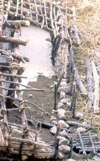
Plastered U-shaped channel perpendicular
to rear wall of Kit Courson house. View east from rear
wall toward the entrance. It is not known whether such
channels served a mundane function, such as perhaps
being ventilation channels leading to small holes in
the outside wall (a possible indication of such was
found in one house.) Alternatively, they could be dividers
that set aside the central rear bench area as a sacred
space, where ritual paraphernalia was kept. Photo by
David Hughes.
|
| |
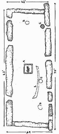
Jack Hughes stands just outside the
apparent doorway of Courson A, a rectangular surface
house. This single post-wall house had two central support
posts, and central hearth, and two exterior trash-filled
storage pits. The interior dimensions were about 4 by
4.6 meters (13 by 15 feet). Photo by Madeline Jeffress,
TAS.
|
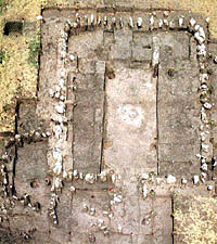
Map of Courson B site showing large
typical Buried City house with stone-based walls, storage
pits, two possible pithouses, and a small square house.
Graphic by David Hughes. Click to see enlarged view
with more details.
|
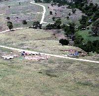
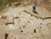
View northwest of excavations of
Eyerly's "Temple" in progress in 1987. Photo
by David Hughes.
|
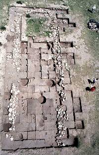
Eyerly's" Temple" is almost
three times the size of any other structure at Buried
City. It may have been a three-room structure, having
three doorways, three hearths, and, possibly two interior
walls. Photo by David Hughes. |
Gould Ruin drawing from Moorehead, 1931. Click to see
enlarged view with legend. |
Detail of the relatively undisturbed
west wall of the temple structure. North is at the top.This
is probably what the whole thing looked like when Eyerly
first exposed it in 1906. Note the vertical slabs on
the interior (to left) of the wall with rubble and boulder
fill about a meter thick and then more vertical slabs
on the exterior or western face of the wall. Photo
by David Hughes. |
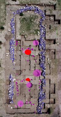
Overhead photograph of Eyerly's Temple with overlayed
features. Click to see enlarged drawing with legend and
extra large final photo without overlay. Photograph and
graphic by David Hughes.
|
|