|
My interest in Caddo archeology is one of a deep
interest in people, of personal feeling for the people
who lived then. If you separate the people from archeology,
it becomes a very dry, scientific analysis.
-Claude McCrocklin
|
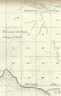
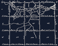
Map produced in 1842 boundary survey
showing "Old Indian Village" in same location
as on earlier Louisiana map. Courtesy Texas General
Land Office.
|
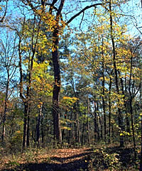
Woods near Caddo Lake. Thick
layers of leaves in the groves of hardwood and pine trees
often obscured the ground surface during survey. Photo
courtesy Texas Parks and Wildlife Department. |
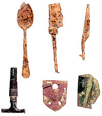
McCrocklin collected numerous artifacts
of the right age to be from a village inhabited ca.
1800-1840, including items of American or European origin.
Top row, left to right: ferrous metal spoon; metal knife
fragment; scissors fragment; bottom row, left to right:
brass spigot cock, bail ear from brass kettle, sheet-brass
patch.
|
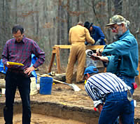
Dr. James Bruseth, left, and Mark
Parsons, right, both of the Texas Historical Commission,
directed excavations at the site.
|
|
As far as anyone knows, it was the first time Caddos
had returned to the last place in their ancestral land
they had called home.
|
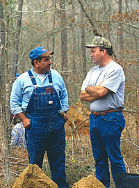
Caddo tribal education officer Richard
Subia discusses finds at the site with Neal McGinness.
|
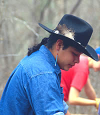
Derek Edmonds of California worked
at the site throughout the week-long excavation.
|
|
Historians knew for a long time that Timber
Hill was somewhere in the Marion County area near Caddo Lake,
but exactly where was a mystery. In the 1990s Louisianan Claude
McCrocklin set out to find it.
McCrocklin is a former cattle buyer from Shreveport
(and World War II pilot and POW) who after retirement took
up archeology as a hobby. He quickly became something of a
legend at ferreting out sites, and by the 1990s he and a crew
of volunteers had located several historical Indian villages
near the Red River. One was a Coushatta village whose members
had interacted often with the Timber Hill people, according
to historians Dan Flores and Jacques Bagur. The two historians
urged McCrocklin to try to find the Kadohadacho village as
well. McCrocklin, for his part, was also eager to locate it.
"To find one village and not the other," he wrote,
"would give an incomplete picture of the two principal
tribes in the area."
Early maps and historical records indicated
that Timber Hill was probably in the vicinity of Jim's Bayou
near the present Texas-Louisiana line. That information, combined
with a passage in an account of the Freeman and Custis Expedition
of 1806, gave McCrocklin a good clue about the site's whereabouts.
The Freeman and Custis Expedition along the
Red River recorded that Chief Dehahuit and 40 of his warriors
left their village (Timber Hill) on the morning of June 30
and arrived on the west side of the river opposite the Coushatta
village about noon on the same day. Flores calculated that
men on horseback traveling at a normal rate would cover approximately
20 miles in one morning. McCrocklin added three miles to approximate
the additional distance across the river to the Coushatta
village. He used a pair of dividers to measure off 23 miles
on a modern map and then drew an arc with that radius west
from the Coushatta village. The place where the arc crossed
Jim's Bayou gave McCrocklin a general place to look.
McCrocklin and his helpers tramped through the
pine forest there, but found nothing that could definitely
be linked with Timber Hill.
Meanwhile, Bagur continued scouring old
records and was finally rewarded with the discovery of two
extremely helpful maps. In the Louisiana State Land Office,
he found an 1839 map that shows an "Indian Village"
immediately south of Jim's Bayou. And in the Texas General
Land Office, Bagur found a map produced in 1842 after the
U.S.-Republic of Texas boundary survey in 1841, which shows
an "Old Indian Village" at the same spot as the
"Indian Village" on the Louisiana map. By 1842 Timber
Hill would have been deserted, or nearly so, and thus termed
an "old" Indian village. Both maps depicted the
same small tributary of Jim's Bayou and a distinctive bend
of the creek just below the village location. What's more,
this "Old Indian Village" was in approximately the
same area as the spot McCrocklin pinpointed with his arc.
"It was then just a matter of going
and confirming the location of the Kadohadacho village,"
McCrocklin explained. "Beginning at the loop in the creek
and moving eastward, we checked favorable habitation locales
until the village components were found." The artifacts
he collected were of the right age to be from a village inhabited
ca. 1800-1840. Most numerous were items of American or European
origin—cast iron and brass cookware, fragments of "china"
and bottle glass, a spigot cock, pieces of knives and spoons,
gun parts, "square" nails, and even an umbrella
part. But the most conclusive evidence of a Native American
presence at the site was a conical brass arrowpoint of a type
commonly manufactured by historical tribes.
Chances were excellent that Timber Hill had
finally been located.
Preparations for a Homecoming
After hearing of the discovery, officials from
the city of Jefferson, about 15 miles from Timber Hill, got
in touch with the Texas Historical Commission (THC) and offered
to sponsor testing to confirm that the site was indeed the
Kadohadacho village. Excavations were scheduled for February
1999. The city would pay the hard costs, the THC would provide
salaries for the archeologists, and other labor would be supplied
by volunteers. Due to the press of other duties, only six
days of excavation were scheduled. That might be enough, however,
to confirm archeologically, and once and for all, that the
site was the long-sought settlement.
Dr. James Bruseth, director of the THC's Archeology
Division, was to be general supervisor of the project, and
THC East Texas Regional Archeologist Mark Parsons would direct
the field operations.
A call for volunteers went out, drawing members
of the THC's Texas Archeological Stewardship Network, a group
of trained avocational archeologists, and other volunteers.
A special invitation was extended to the Caddos in Oklahoma
to join in the effort. Cecile Carter (Caddo historian), Richard
Subia (tribal education officer), Abraham Pedro, and Derek
Edmonds were among those who shoveled and troweled the soil
side-by-side with the archeologists. Tribal Chair Vernon Hunter,
Stacy Halfmoon, Bobby Gonzales, and Brien Haumpo had already
visited the site soon after it had been discovered. All are
probably descendants of the Timber Hill people, according
to Cecile Carter. As far as anyone knows, it was the first
time Caddos had returned to the last place in their ancestral
land they had called home.
|
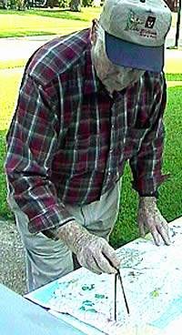
Claude McCrocklin, the avocational
archeologist who located the site, shown at work with
a map. Photo by Mark Armstrong.
Click images to enlarge
|
Historian Jacques Bagur located an
1839 map from the Louisiana State Land office showing
an Indian Village (circular pattern at top, center)
just south of Jim's Bayou. (Click to enlarge.) Map courtesy
of Louisiana State Land Office, Division of Administration,
Baton Rouge.
|
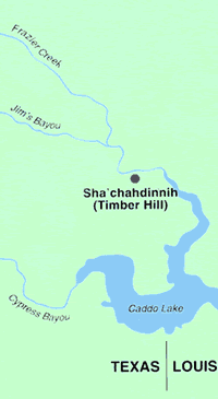
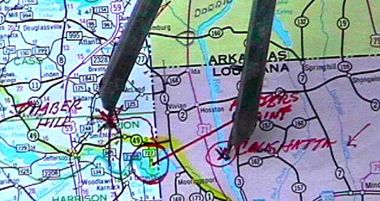
Location of Sha'chahdínnih
shown in relation to previously discovered village sites.
(Click to see full image.)
|
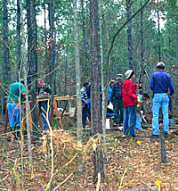
Archeologists focused excavations
on a ridge top believed to have been the site of a small
hamlet or farmstead. On private land, the area today
is used for timber production.
|
Abraham Pedro, an Arapaho with Caddo
connections, and Caddo historian Cecile Elkins Carter
take a break from excavations. The two were among a
number of Native Americans who came together to work
at the site. According to Carter, all are probably descendants
of the Timber Hill people.
|

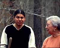
Brien Haumpo, who traveled from Oklahoma
to visit the site, hopes archeology can help restore
the nearly forgotten past of his Caddo ancestors. Photo
by Russ Bronson, courtesy The Dallas Morning News.
|
|