Diet and Health
The prehistoric cemeteries of the South Texas Plains, such as Loma Sandia, Morhiss Mound, Silo, and Olmos Dam, are remarkable windows that are providing insight into diet and health of the native peoples of the region. On a global level it is unusual for hunters and gatherers to use cemeteries and we would like to know why that was the case on the South Texas Plain and the greater coastal plains of Texas. By exploring the diet and health of individuals from these places we may obtain clues as to why they made use of cemeteries.
Throughout prehistory the hunters and gatherers of the South Texas Plains returned to favored gathering, hunting, camping and fishing spots to obtain these resources according to the changing seasons as long as the territory in which seasonal resources were accessible and not put off limits by other groups. The basic characteristics of the hunter-gatherer diet on the South Texas Plains are well known.
White-tail deer was typically a mainstay element in the hunter-gatherer diet. Other important game included pronghorn (antelope), bison, as well as smaller terrestrial creatures spanning the size range from collared peccary, raccoon, opossum, turkey, jackrabbit, cottontail rabbit, striped skunk, ground squirrel, cotton rat, pocket gopher and snails, among others. The rivers and streams yielded bowfin, catfish, freshwater drum, gar, freshwater mussels and a variety of turtles, as well as frogs, ducks and alligators. On the coast, on the southeastern periphery of the South Texas Plains, were a wide variety of fish and mollusks, particularly black and red drum. Animal foods were only half the hunter-gatherer economy on the South Texas Plains, and probably not the more reliable half in many seasons.
Plant foods were essential, life-saving mainstays, especially the region’s two most celebrated annual crops. In the late summer masses of tunas were harvested from the dense inland prickly pear fields. Soon thereafter, huge pecan harvests were often possible along the eastern rivers of the region. Other food sources, which must have been at times as essential and dependable, were mesquite beans and roots and tubers. Still other plant resources include acorns, hickory nuts, grass seeds, fruits such as persimmon, berries, and the tiny fruits of agarito and other shrubs.
Among many of the region’s peoples, especially those whose home territories lay east of the Nueces River, when someone died they were often taken to cemeteries to be buried. Cemetery sites like Loma Sandia, the Morhiss Mound, Silo Site and the Olmos Dam Site were special locations for Native Americans, for they returned to them, sometimes for thousands of years, to bury their kin (see Mortuary Traditions.) While it’s difficult for archaeologists to know the special meanings these places must have held, their skeletal remains offer valuable evidence about their diet and health and ultimately offer clues as to why some hunters and gatherers on the South Texas Plain used cemeteries, in contrast to many other peoples elsewhere in the world whose lifeways depended on wild plants and animals.
Physical anthropologists study the bones and teeth and can determine age at death, sex, and general health evidenced by, fractures and other injuries, diseases that affect the bone, arthritis, dental health and occasionally the cause of death. One conclusion of these investigations is that generally the inland groups, such as those buried at Morhiss Mound and Olmos Dam, were generally healthy and had adequate food supplies most of the time. In contrast people from other cemeteries on the coast showed more signs of stress and disease, as did the latter peoples buried at some inland cemeteries such as the Coleman Cemetery in southwestern Bexar County.
The expression “we are what we eat” sums up recent results of a chemical study of small samples of human bone that tells us more about the diet. Dr. Robert Hard of the University of Texas at San Antonio and physical anthropologist Dr. Anne Katzenberg of the University of Calgary applied funding from the National Science Foundation to analyze small pieces of bone from Texas cemeteries to measure the levels of stable carbon and nitrogen isotopes preserved in the bone tissue. Since various categories of plants and animals have different levels of stable carbon (13C) and nitrogen (15N) isotopes they act like tracers that leave a record in an organism’s tissues as the carbon and nitrogen moves from the environment to plants and animals and their consumers including people. These tracers allowed us to identify some of the classes of food the people consumed.
Our study examined human remains from twelve cemeteries including Morhiss Mound, Loma Sandia and Olmos Dam cemeteries as well as a prehistoric cemetery near Corpus Christi known as Cayo del Oso, located on the shore of Oso Bay. Unfortunately the badly deteriorated bone from the Loma Sandia cemetery did not yield usable results. The remaining three cemeteries represent three different ecological zones. One is the Coastal Zone that incorporates the shore line, bays, estuaries, river mouths and marshes within about 50 km of the coast and includes the Cayo del Oso site.
Two zones within the South Texas Plain proper were sampled by our study, the Riverine-Savanna Zone and the Inland Zone. The Riverine-Savanna Zone extends from the western boundary of the Coastal Zone westward to an elevation of about 200 ft. Here the land is flat and low and the rivers have wide floodplains. As sea levels rose thousands of years ago, the floodplains filled with alluvium, decreased their gradient and the flow of the rivers slowed, causing them to meander more and form oxbow lakes, swamps and sloughs, where freshwater resources became abundant particularly in the spring when fish spawn and some species were trapped in the backwaters by falling floodwaters. Archaeologist Dr. Grant Hall referred to this area as containing “natural catfish farms.” This zone contains many of the largest prehistoric hunter-gatherer cemeteries in the state, including Morhiss Mound. (Refer to the Ancient Places layer on the interactive map on the South Texas Plain Main page. The medium green region of the map is roughly equivalent to the Riverine-Savanna Zone.)
The Inland Zone extends west from the Riverine-Savanna Zone and north to the edge of Edwards Plateau. The flat to hilly land arises from the 200 ft. contour interval to about 1000 ft elevation in the vicinity of San Antonio. The upstream reaches of the major rivers tend to be narrow, down-cut (incised), and less sinuous than the lower stretches and they have numerous tributaries. Fish and mussels are present in the streams, but not in the density of the lower reaches of the rivers in the Riverine-Savanna Zone. The Olmos Dam cemetery is in the Inland Zone.
Changing levels of 13C and 15N isotopes in the bone cannot tell us what specific foods were eaten, but when used together they can indicate what classes of food were consumed. The five classes relevant to this discussion are: 1) most terrestrial (land-based) plants, 2) terrestrial animals, 3) cactus such as prickly pear, 4) freshwater resources including fish and mussels and 5) marine (saltwater) fish and mussels.
The results of our study at first did not seem surprising. Among the Inland Zone samples, the levels of 13C and 15N were low, indicating that the people were largely dependent upon terrestrial plants and terrestrial animals, with minor levels of freshwater resources and cactus. In marked contrast are the results from the coastal Cayo del Oso cemetery. Here the levels of 13C and 15N were notably elevated suggesting marine resources were the most important, followed by terrestrial plants. Terrestrial animals seem to play a surprisingly minor role in the diet, and cactus does not appear to be significant either. Even more surprising is the apparent virtual absence of freshwater resources, despite their presence up the nearby Nueces River and tributaries. Apparently, coastal peoples were coastal peoples.
The individuals from Morhiss Mound had the most diverse diet of all; they used four of the resource groups. Their diet was dominated by freshwater resources, terrestrial animals and terrestrial plants. Marine resources are indeed present, but there is not much evidence of cactus use.
At first glance these results seem straight-forward. People in the Inland Zone concentrated on terrestrial plant and animals resources; people in the Riverine-Savannah Zone ate a wide variety of resources, particularly freshwater resources, and the inhabitants of the Coastal Zone ate marine foods. Upon closer consideration, however, there are several remarkable elements of these findings. The first is that the Native Americans from Cayo del Oso did not have a more diverse diet. Their nutrition included marine resources and terrestrial plants. We must ask, why weren’t they using more terrestrial animals, freshwater resources and cactus? As any fisherman knows, the fishing isn’t always good in the same spot and multiple resources are needed to compensate for the ebb and flow of different foods through the seasons and years.
We think the answer lies in the Riverine-Savanna Zone. Here we find the largest cemeteries, people in generally good health, and the most diverse and nutritious diet centered on the wide floodplains. One likely scenario is that the Riverine populations formed territories and tightly controlled access to their lands, limiting the degree that coastal peoples could move inland to hunt and fish if resources were in short supply along the coast. A number of osteological studies of coastal populations along the south Texas coast show that coastal populations were in poorer health than people either in the Inland or Riverine Zones. In contrast people in the Inland Zone probably had a much lower population density, allowing both Inland and Riverine groups to exploit a wider range of territory to off set seasonal shortfalls.
The formation of established territories is likely related to the use of large cemeteries, in that people were constrained to a relatively limited area and the cemeteries perhaps were a way of symbolizing their control of an area. Further studies of the Morhiss Mound remains and the publication of the recently excavated Early Archaic cemetery at the Buckeye Knoll site will allow us to examine how early these territories formed, as well as address many other questions, from diet and health, to group size, regional and extraregional interaction spheres, and much more. All in all, the study of prehistoric cemeteries gives us unequalled knowledge about the native peoples of the South Texas Plains and adjacent regions such as the Prairies and Marshlands along the coast.
Contributed by Dr. Robert Hard, professor of anthropology at the University of Texas at San Antonio, and former director, Center for Archaeological Research (UTSA).
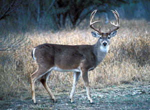
Today, the South Texas Plains region is a favored deer-hunting haunt. The same was true in prehistoric times. Deer were the number one game animal, a critical resource for food, tool-making materials, and leather. They were components of the diets of all peoples throughout the region throughout Archaic and Late Prehistoric times. Photo courtesy Texas Parks and Wildlife Department.
|
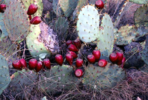
Prickly pear near the Choke Canyon Reservoir loaded with ripening tunas. In the Inland Zone of the South Texas Plains, late summer masses of tunas were harvested from the dense inland prickly pear fields.
|
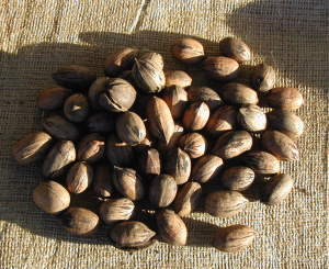
Huge pecan harvests were often possible along the eastern rivers of the region in the Riverine Zone, but these tended to occur every 2-3 years. Photo by Steve Black. |
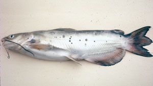
Food resources found in the Riverine Zone, included catfish, freshwater drum, gar, freshwater mussels and a variety of turtles, as well as frogs, ducks and alligators.
|
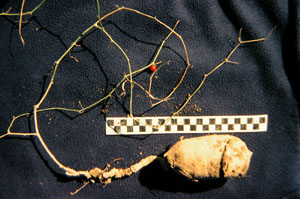
Globeberry roots were probably among the many root foods that the region's hunter-gatherers depended on at times. Photo by Phil Dering.
|
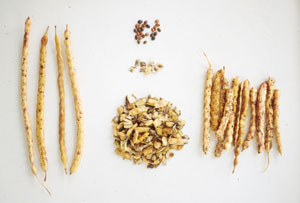
Mesquite beans were a major seasonal resource in the Inland Zone. Whole pods, far left and right, seeds, center top, endocarps, center middle, broken pods bottom middle. Photo by Phil Dering.
|