Good archeological field work is all about recovering as much informative data as is possible at a site, and that requires having a carefully thought out research plan. The Lake Naconiche project involved three major investigative steps. First, archeological sites were identified during a thorough survey of the project area. The survey was important because of the new sites that were discovered in the process. Next, the identified sites were evaluated through testing: digging a series of small “test” pits to sample the buried occupational deposits. The project archeologists used these data to prepare a research design, the scientific plan of attack, for major excavations.
Finally the research team returned to the field and excavated the most promising sites to find, systematically document, and sample the in-the-ground archeological record. These recovered data — field observations and information obtained from the artifacts and samples analyzed in the lab — allowed the investigating team to explain what was discovered about the sites and put forth reasoned interpretations. Archeologists term the major excavations a “data recovery” or "mitigation" program, meaning that the research is intended to mitigate the loss of information caused by the construction of the reservoir on Naconiche Creek.
The earliest excavations at Caddo sites (late 19th century through the 1930s) involved digging mounds and cemeteries mostly at the larger, most obvious sites. When archeologists encountered evidence of domestic houses away from the mounds, they sometimes excavated the houses. But they did not dig between the houses, and thus did not find all kinds of “features,” such as cooking areas, storage pits, and many other traces of human activities at Caddo sites. Researchers now know that we have to document and try to understand the full range of archeological features, including the houses, the middens (trash deposits), the burials, the courtyards, and other kinds of outdoor activity areas — all are important pieces of the puzzle of day-to-day life. For example, if we dig only the houses we will miss details about important things like storing agricultural surplus: were there elevated storage areas, underground storage pits, or both? We need to know what happened all over the site, and not just within the houses. To make convincing conclusions, archeologists need to draw on the preponderance of evidence obtained from thorough investigations of entire sites.
During the data recovery stage at Lake Naconiche a remote sensing or geophysical expert was called in to conduct magnetometer investigations of certain site areas to look for magnetic anomalies. Such anomalies can be caused by cooking fires and many kinds of soil disturbances, such as the digging of pits. This is possible because much of the clay subsoil in East Texas is iron-rich, creating a low-level natural magnetic field. Prehistoric fires created strong magnetic anomalies, while soil disturbances often disrupted the natural background patterns on a smaller scale. The Caddo did not use iron tools, but their pottery was made from fired iron-rich clay, and burned rock (cooking stones) also create magnetic signatures.
A magnetometer is a very sensitive device that detects and records magnetic variation during systematic sweeps or passes across a site. The resulting signal plots or magnetic field variation are used to define magnetic anomalies and to look for tell-tale patterns caused by certain kinds of disturbances and activities. Unfortunately, the patterning of magnetic anomalies in the Naconiche signal plots was often not immediately obvious. Caddo sites tend to be subtle "reads" and the sites at Lake Naconiche followed this pattern. Caddo sites tend to have deep sandy deposits covering the deeper, subsurface clay layers. Sand tends to “dilute” remote sensing data (such as magnetometer signals) and so features, pits and postholes, for example, are not as obvious as in sites that are shallow, or where features had been dug directly into iron-bearing soils; the latter type will give back a very strong signal. Nonetheless, numerous magnetic anomalies were detected.
In order to better understand the magnetometer data, the Lake Naconiche research team did many shovel tests (small, shovel-dug probes) across the Tallow Grove and Beech Ridge sites, allowing the construction of artifact density plots. They then overlaid the plotted magnetometer readings atop the artifact density plots, and noted matches and mismatches, some caused by natural disturbances but others the result of human activities. The archeologists had hoped to find clear signatures showing where houses and other kinds of cultural features such as pits and graves were present. The patterning was rarely clear cut.
Although the magnetometer work failed to yield clear magnetic signatures of structures, the plotted artifact densities pointed to concentrated occupation areas. The next logical investigative step was to dig somewhat larger areas — a series of one by one meter (1 x 1 m) excavation units — in and around locations where magnetic anomalies and artifact concentrations overlapped. These revealed the nature of the occupation areas and helped determine what kinds of activities took place there. It was only then that the team started to discover features, such as pits and the postholes that identified the area of a house.
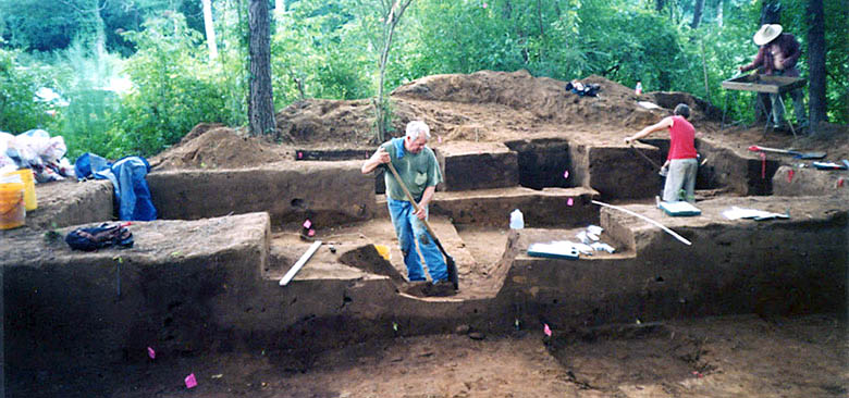
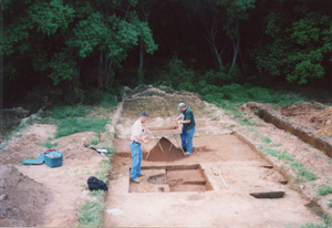
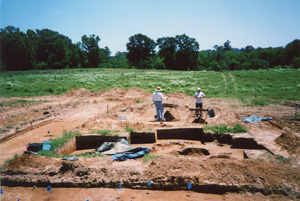
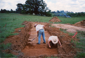
Once an area with structural evidence became apparent, excavation areas were enlarged with more units, many contiguous (side by side), thus uncovering large "block" areas. Skilled backhoe operators gently scraped around these areas to expose any buried features that might be present outside the houses.
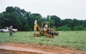
Readers will perhaps be surprised to learn that earth-moving equipment was used to investigate the Lake Naconiche sites. The use of heavy equipment in excavation represents a strategic change in how modern archeologists investigate Caddo sites.
In the past archeologists mainly used machines such as the backhoe to cut trenches across sites at the beginning of the excavation process. When they discovered something, they would expand their excavation by hand—it was a “hit or miss” situation. Now researchers shovel test first, then open small pits to expand a “hit” and focus on areas where a large block can be opened and excavated by hand. Machine excavation is used to supplement and prepare for hand excavation and to allow archeologists to explore beyond the excavation blocks.
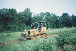
One of the main uses of machine excavation by the Lake Naconiche research team was for controlled scraping. This was not a means of looking for or collecting artifacts, but instead, it was designed to make it easier to find the "extramural" features (those lying outside the house walls). When properly done, scraping a site in this way allows archeologists to identify the best areas in which to concentrate their work by hand.
The Archeological Sites and Their Ages
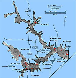
What the team found during the archeological survey was that the project area was full of archeological sites. Site density was very high and a total of 61 prehistoric sites were identified. Of these, 10 prehistoric sites were recommended for test excavation because the field surveys indicated that these sites held potential clues to questions involving not only the early origins of the Caddo, but also the rise of sedentary life and the development of agriculture in Northeast Texas.
During the archeological survey and shovel testing, at the beginning of work on the project, prehistoric Caddo graves were encountered at two additional sites, Tallow Grove (41NA231) and Beech Ridge (41NA242). Consequently these two sites were determined to be eligible for inclusion in the National Register of Historic Places and as State Archeological Landmarks. This designation meant that these sites were set aside for special consideration and subsequent data recovery upon consultation with the Caddo Nation of Oklahoma (see Caddo Involvement).
Test excavations at the 10 sites were carried out between October 2000, and January 2001. At the conclusion of the test excavations, the Foggy Fork, Naconiche Creek, and Boyette sites were considered to be the most important sites to be targeted for data recovery. Because the Lake Naconiche project required federal permits, the work had to comply with the National Historic Preservation Act (NHPA) of 1966. Section 106 of the NHPA requires federal agencies to consider effects on cultural properties and the implementing regulations associated with this federal law (36 CFR 800) spell out how decisions are to be reached regarding how to deal with important cultural properties such as the above-named sites. In NHPA parlance these three sites are considered significant because they “are associated with events that had made a significant contribution to the broad patterns of our history” and they “had yielded, or may be likely to yield, information important in history or prehistory”. The NHPA created the National Register of Historic Places and archeological sites judged to be eligible for inclusion on the National Register are those that qualify for data recovery investigations if they are to be affected by a Federal project..
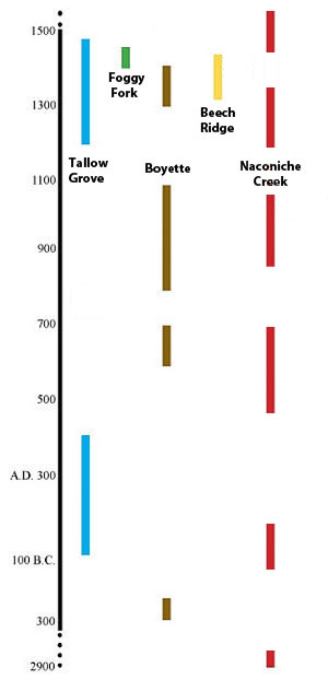
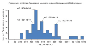
The most intensive prehistoric settlement in the Lake Naconiche project area occurred within the last 1300 years or so, within the latter part of the Woodland period and throughout the bulk of the Caddo era. However, radiocarbon dates from the Tallow Grove, Boyette, and Naconiche Creek sites also testify to earlier, repeated, if not necessarily long-lasting, occupations by groups that began to frequent the area around 2000-2500 years ago. The most intensive settlement of the Naconiche Creek valley in prehistoric times occurred after ca. A.D. 1100 and probably peaked in the 15th century A.D. OCR (Oxidizable Carbon Ratio) tests measure the biochemical degradation of carbonized organic matter. The OCR dates acquired for Naconiche Creek site samples indicate the same temporal patterns as the radiocarbon dates.
Based on radiocarbon dates from the Lake Naconiche sites, the main Caddo component at the Tallow Grove site ended at approximately A.D. 1480, having started in the early part of the 13th century A.D. The Foggy Fork site is a single component Late Caddo period occupation that took place in the first half of the 15th century A.D.
The Naconiche Creek site is well dated. This site had the best preserved and largest sample of animal bone of any of the Lake Naconiche sites, as well as dateable charred plant remains and wood charcoal from feature and midden contexts. The 18 radiocarbon dates from the Naconiche Creek site indicate that the archeological deposits were the product of at least six different occupations. Based on the radiocarbon dates, the earliest occupation at Naconiche Creek (the site) began as early as 2900 B.C. and the last occupation ended in the mid-17th century A.D. The dates occur in a roughly stratified order, youngest to oldest, from top to bottom. The main occupations occur in Woodland and Late Caddo periods.
Nine radiocarbon dates ranging from about A.D. 1250-1430 were obtained from a prehistoric Caddo component at the Beech Ridge site. Keep in mind that radiocarbon dates are actually statistical probability age estimates ("assays") that are expressed with "plus or minus" error ranges that may span 80 or more years within which the true age actually falls. Raw radiocarbon assays must be calibrated and corrected to accurately determine the most likely date range (see Radiocarbon Dating entry in the TBH Glossary). Taking these factors into consideration, it is most likely that the Middle Caddo period component at Beech Ridge occurred mainly between A.D. 1340-1430.
In the Block I excavations at the Boyette site, dates from three Woodland period features are clearly from a single component that spans the latter part of the 7th century A.D. and most of the 8th century A.D. The mean calibrated intercept for the three dates is A.D. 743. Mean age range from these features is A.D. 670-847. The one child burial in Feature 1/10 has an age range of A.D. 1230-1300. In Block II, a relatively early Woodland period occupation is marked by two calibrated dates with ranges of 280-35 B.C. The Caddo occupation in Block II has four dates. The mean date for these four dates is A.D. 960, and age ranges for these are A.D. 873-1075. The final Caddo use of the Boyette site was from a burial feature in Block II that dates from A.D. 1290-1410.
Tallow Grove Site (41NA231)
The Tallow Grove site was situated on a small Late Holocene terrace of Naconiche Creek not far south of the confluence of Naconiche and Telesco creeks. The Beech Ridge site was about 100 m north of Tallow Grove. The main occupation of Tallow Grove took place between the early part of the 13th century A.D. and approximately A.D. 1480, with an earlier Woodland period occupation that dates from 110 B.C. to A.D. 435.
During the archeological survey investigations at the Tallow Grove site, five shovel tests and two backhoe trenches were excavated. The archeological deposits at the site were 60-80 cm (24-32 in) thick. Midden deposits with preserved animal bones and charred plant remains were identified in the southwestern part of the site. A radiocarbon date of A.D. 250-430 was obtained on charred nutshells from the lower part of the midden, suggesting that the deposit began to accumulate during the Woodland period.
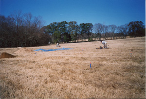
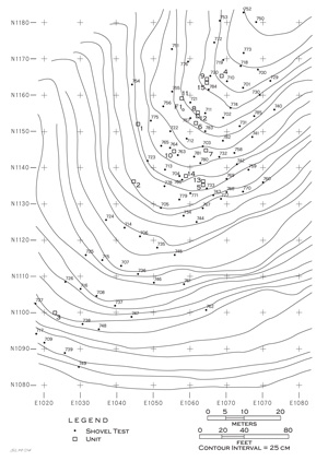
The first task in the data recovery work at Tallow Grove, as well as at the Beech Ridge site, was to mow the pasture grasses and conduct remote sensing investigations across the terrace. The remote sensing covered an area 185 meters (607 feet) north-south and a maximum of 80 meters (262 feet) east-west. Following this, intensive shovel testing was completed to gather information on the density and character of the archeological materials at the site, and also to determine the location and extent of midden deposits.
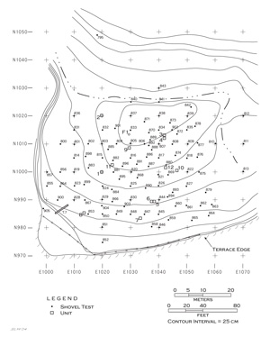
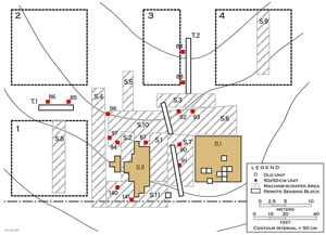
A total of 106 shovel tests were excavated at the site over an area covering a 55 x 65 m area (about 0.9 acres) during the data recovery investigations. More than 97% of the shovel tests yielded prehistoric archeological remains. The archeological deposits cover the area from the Naconiche Creek terrace scarp on the south and west to the old creek channel on the north and east. Prehistoric Caddo pottery sherds and animal bones were concentrated in the southern part of the alluvial landform, primarily below the crest of the terrace.
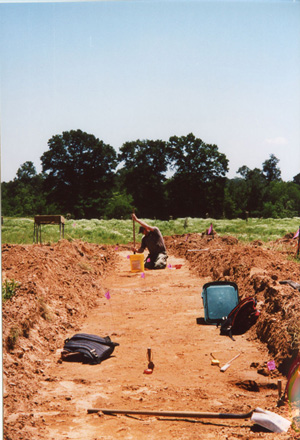
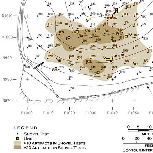
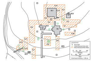
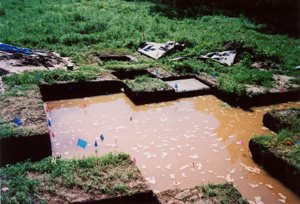
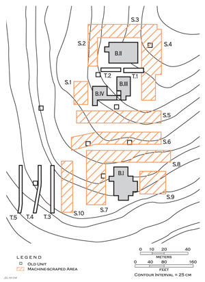
The shovel testing revealed that Tallow Grove contained a well-preserved archeological deposit. Plotting the distribution of the shovel tests with the highest densities of artifacts (more than 80-160 artifacts per square meter) highlighted an area approximately 30 x 45 meters where Caddo deposits were concentrated. Much of this area had well-preserved midden deposits. Building upon the shovel testing, the remote sensing results, and the findings of the initial series of 1 x 1 m units, four different block excavations of contiguous 1 x 1 m hand-excavated units were dug at the Tallow Grove site.
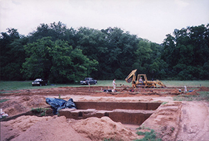
As the block excavations neared completion, the front end loader of a backhoe was used to carefully scrape a number of areas around the blocks to search for and excavate other features and midden deposits. Fourteen different machine scraped areas were eventually excavated at Tallow Grove. The machine-scraped areas ranged from 2-4 meters in width and 4.75-17 meters in length. Most of the features that were exposed in the scraped areas were cross-sectioned and excavated.
In total, 81 square meters (and 38 cubic meters) of archeological deposits at Tallow Grove were excavated in a controlled manner with shovel and trowel. Another 473 cubic meters (over 5000 square feet) were examined to search for features using machinery. Collectively, this represents approximately 40% of the most intensively used part of the site, and a huge amount of moved earth.
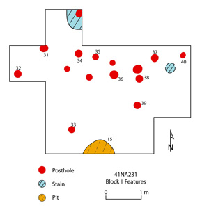
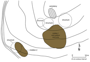
Numerous cultural features were identified and excavated at the Tallow Grove site. The most notable include the eight burial features in the Block V cemetery as well as many large pit features in and around Block I. There were two midden deposits (Middens 1 and 2) as well as some posthole and hearth evidence of four structures.
Among the 87 features were 40 postholes, 18 large (> 1 m in diameter) basin-shaped pits, 16 small (<60 cm in diameter) pits, the eight burials (and their accompanying funerary objects), two hearths with associated oxidized sediments, two fire-cracked rock (FCR) concentrations, and one ground stone tool concentration. The ground stone tool concentration and one FCR concentration were identified in sediments stratigraphically below the 13th-15th century Midden 2. Although these two features were not dated, they were associated with an earlier prehistoric use of the Tallow Grove site, probably during the Woodland period. The remainder of the cultural features were from the prehistoric Caddo occupation of the site.
The largest concentration of features at Tallow Grove was in Midden 1 and Block I . The midden itself had a number of large and small basin-shaped pit features in it, and they all appear to have been situated in extra-mural or outdoor locations, particularly across much of Block I and areas to the east, south, and southwest.
Interpreting Postholes
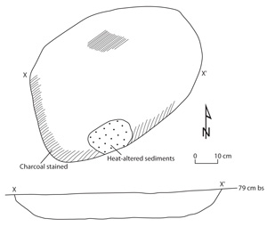
As mentioned earlier, identifying features in sandy sites can be tough. The Lake Naconiche team paid close attention to each scrape of the backhoe and trowel. During the excavation, the archeologists would occasionally expose a small circular stain that appeared as a different color on the soil. These stains were usually a little darker than the surrounding soil. The soil color was different because it represents a filled hole that once held a wooden post and decayed organic materials had settled into the decomposed post’s hole over time.
After these kinds of stains were observed, excavators would draw a circle around them and then cut them in half with a trowel ("section" them) to get a look at each stain's "profile", or shape in cross-section. The profile determined whether they had discovered a posthole or not. If it is a posthole, the stain will have parallel sides and a rounded, or flat, bottom, just as one would expect a posthole to appear. Sometimes they would find some residue of the original post, perhaps burned. If it is not a posthole stain, the profile would appear to go off at odd angles, as an animal’s burrow might do.
The archeologists did not use samples of posthole organics for dating purposes. This is because the researchers could not know if the organics were all contemporaneous, or were blown or settled into the hole at some later date. Even an obvious burnt post fragment would be rejected for dating purposes because people living at the sites could have been re-using or recycling old timber they had used for construction. Understanding how archeological sites formed over time avoids misinterpretation of data.
The archeologists on this project preferred to take charred organic samples for dating from storage pit fill. Caddo occupations had big pits, storage pits they also threw trash into. This is perfect for dating purposes because most of the time there is a clear separation between dumping events. Storage pits also allow for more material recovery for other types of analyses than the smaller postholes.
Posthole patterns at Tallow Grove
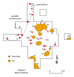
The Block I excavations revealed that basin-shaped pit features were situated to the east and south of an arc of postholes likely marking part of a structure. The portion of the exposed structure wall extended at least 6 meters north-south across the block, with portions of a second wall curving to the west away from the midden deposits. The team surmised that the structure was likely circular in shape. There were several shallow and more ambiguous posthole stains inside the structure arc that may have represented the remnants of internal screens or racks.
A gap in postholes on the posthole arc may mark an entranceway that led directly to Midden 1, which accumulated primarily outside the structure area to the south, east, and west. There were many pit features just to the east and south of the structure wall arc, suggesting a locus of outdoor work activities (e.g., cooking and heating of foods, processing hides and other goods, stone tool manufacture) as well as plant food storage and later trash disposal in the large basin-shaped pits. A cluster of postholes to the east of the posthole arc may mark the area of a ramada or covered work platform. The possible ramada marked by this cluster of postholes was about 3 m on a side and squarish in shape, about the same size as 17th century ramada structures excavated at sites along the Red River.
Among the historic Caddo, ramadas served as elevated “patios.” raised covered platforms where people could get out of the sun while doing work. They are identified archeologically by their rectangular shape as defined by postholes at the corners and relatively small area. Examples found at Lake Naconiche were not particularly well preserved. In several cases rectangular posthole patterns were documented that are inferred to represent ramadas.
Block II had a second posthole arc from another structure or area of structural deposits located north and west of Midden 1 and southwest of the Block V cemetery. The arc was at least 4 m in length and apparently represented a curving line of exterior wall post supports. The close and off-set juxtaposition of a number of the postholes and posthole stains suggests that the wall was rebuilt at least once, or that occasional posts were replaced as they rotted at the ground level. Machine scraping north of Block II failed to uncover other obvious associated wall support postholes. There was one large basin-shaped pit feature (Feature 15) about 2 m south of the arc of postholes. This was probably a storage pit used by the family that occupied the structure.
Few postholes, possible posthole stains, or other features were identified in the Block III excavations. One apparent feature was a concentration of ceramic sherds and fire-cracked rock. Although there were only a few postholes and probable posthole stains in this block excavation, their location near to a hearth feature constructed over a post—suggests that they were part of a third arc of postholes north of Midden 1 for a structure built around the hearth. This structure would have been southeast of the Block V cemetery. The distance between the Block III postholes and probable posthole stains and the Feature 46 hearth suggests that this structure may have been about 6 m in diameter.
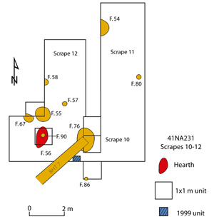
A fourth area with numerous cultural features was in and around Midden 2. In this area were several posthole and a large hearth (Feature 56) built over a post (Feature 90), suggesting it was a central hearth for a structure, and a number of pits of various sizes.
The various postholes recognized across the Tallow Grove site fall into three groups based on size. The smallest group (n=7) had a mean diameter of 14.7 cm (approximately 5.7 inches). They were found primarily among the postholes in Blocks II and III, and under the Feature 46 hearth near Block III, although single examples of these smaller posts occur in Block I and in Midden 2. That these smaller posts were found in each area with a possible Caddo structure, but not in any substantial numbers anywhere on the site, suggests that smaller wood posts were used in construction along with the larger posts that more commonly define wall post supports.
The second group of postholes (n=27) had a mean diameter of 21 cm (approximately 8 inches). These represent the most common posthole size used in house construction, and those wall posts used here were approximately the same size as wall posts at the contemporaneous and nearby Beech Ridge site. Almost half of the regular-sized postholes (48%) had charcoal-flecked fill compared to only 29% of the smaller posthole group. This charcoal-flecking was probably the product of construction activities in the Block I area taking place amidst the accumulation of an extensive midden deposit and outdoor working area just outside the apparent walls of the Block I structure.
The postholes that may mark a ramada structure (including Features 11-12, 16-19, 20, 30, 42, and 43) were the same size as the common wall support posts, with a mean diameter of 21 cm. At the McClelland site in northwestern Louisiana, a ramada excavated there had larger postholes (ca. 25 cm, or 9.8 inches) in diameter at the corners. This was not the case with the possible ramada in the Block I excavations. Only one of the posts with this possible structure was 25 cm in diameter, and all the others ranged from 18-22 cm in diameter.
The third group of postholes (n=4) were on average 29 cm (11.2 inches) in diameter. One (Feature 90) occurs under a hearth in Midden 2, one was near a corner of the possible ramada in Block I (Feature 30), a third was along the posthole arc in Block I (Feature 21), and the last large post occurs by itself in the southern part of Midden 1 (Feature 4). This wide and apparently random distribution of larger posts at the Tallow Grove site suggests that the larger posts were not used for any particular special purpose or had any special meaning for its inhabitants. On occasion, a larger wood pole was apparently used as a wall post or for other everyday ancillary facilities (i.e., screens or racks). However, special uses for poles have been documented at several prehistoric Caddo sites where large posts were apparently used to mark special deposits, such as buried and burned structures, or plaza areas.
Tallow Grove Storage Pits
The 18 large pits found at the Tallow Grove site were basin-shaped and at least 60 cm (23 inches) in diameter, and often much larger (>1 m in diameter and 30-40 cm in thickness), with sloping sides and rounded bottoms. These larger pit features could have held about 8.5 bushels of plant foods (ca. 200 kg, or about 440 pounds, of food stuffs), and their volumes range from 3 bushels to 19.7 bushels. The large pits were concentrated in Midden 1 and Midden 2, with a few others scattered in the vicinity. The sheer volume of potential food storage is impressive. The fill in these pits was typically a dark brown to very dark brown sandy loam, but with little to no evidence of stratification, discrete fill zones, or oxidized/fired areas. At some point most of them were used as trash receptacles, and a number contain an abundance of broken artifacts (ceramic vessel sherds), lithic debris, animal bones, and charred plant remains. One pit in Block I (Feature 25) contained the cranial remains of a purposefully buried dog.
The largest basin-shaped pit feature was Feature 76 in Midden 2. The pit was approximately 165 cm in diameter, and more than 40 cm in thickness. It could have held an estimated 19.7 bushels of plant foodstuffs, almost 500 kg (1100 pounds). If those foodstuffs were maize, ca. 500 kg of maize would be sufficient to feed a family of five (adults and children) for 1.5 years. This 15th century A.D. pit feature had a very dark brown fine sandy loam fill with charcoal and bone flecks as well as preserved animal and plant remains, lithic debris, an arrow point, sherds, burned clay, and a deer mandible from near the base of the pit.
Sixteen smaller pit features occurred amidst the larger basin-shaped pits, concentrated in and in the vicinity of the Midden 1 archeological deposits. They were less than 50-60 cm (20-23 inches) in diameter, had sloping sides and rounded bottoms, but also contained a dark brown to very dark brown sandy loam fill like the larger basin-shaped pits. The primary function of these smaller pits is uncertain. None of them had evidence of in situ heating, such as oxidized lenses or heat-baked floors or walls, but the features often contain charcoal and bone flecking as well as an abundance of artifacts that had apparently been discarded in the small pits. One pit (Feature 87) had a prominent charcoal-stained lens at the base of the feature, suggesting that some cooking may have taken place in it, or perhaps the charcoal lens was the remnant of the use of the feature as a smoking pit.
There is something very different about the Tallow Grove site in that it does not have a courtyard. It had a number of midden deposits and many, many large storage pits, many more than were needed for the people that were living there. The Beech Ridge site had almost no chipped stone while the Tallow Grove site had a large amount of it. It is as if there were some lithic craftsmen living there and that the site was also a communal storage area. They had enough storage to supply a lot of people food for up to a year. Tallow Grove was definitely not a normal farmstead.
Tallow Grove Burials
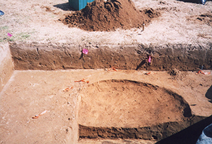
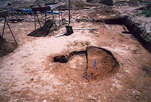
Eight prehistoric Caddo burials were documented in a small cemetery in Block V. The cemetery was situated on the crest of the alluvial landform, not far north of the remnants of several structures and an extensive midden deposit (Midden 1) and outdoor work area. The cemetery area was completely excavated by a combination of shovel skimming, troweling, and machine scraping.
Human skeletal remains were very poorly preserved. The relative age (i.e., adult versus juveniles and children) of the deceased individuals could be determined only in a few cases. Based on the bioarcheological information as well as the size and shape of the burial pits, it appears that the eight burial pits were those of adult Caddo Indians. Burial pits range from 167-192 cm in length and 56-72 cm in width. In demographic terms, eight deaths could be expected to represent only 13-40 elapsed years in a prehistoric Native American group with a population of 20 individuals and a normal death rate of between 1-3% per year.
At Tallow Grove the deceased were apparently laid out in the burial pits on their backs in an extended position, with their heads at the southern part of the pits (and thus facing north). Burial pits primarily were oriented northwest-southeast with the head facing northwest (in the direction of the summer solstice), but one burial had a north-south orientation, and one other had a roughly east-west orientation.
The dominant northwest-southeast burial pit orientation is shared by the cemetery at the Deshazo site (41NA27) on Bayou Loco in Nacogdoches County, Texas, several burials at sites at Lake Sam Rayburn in the southern part of Nacogdoches County, and at a related Middle Caddo period occupation farther away: 41HS74 in the Sabine River drainage.
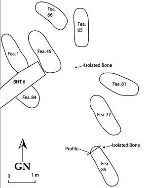
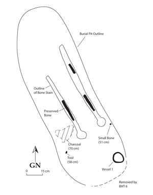
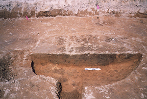
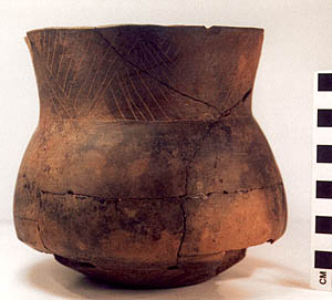
Feature 1 was encountered during geoarcheological trenching during the 1999 archeological survey. At that time, two ceramic vessels (one nested inside another) and a small amount of adult cranial bones were exposed and documented. In 2004, Feature 1 was completely exposed and excavated. A sherd from the fill of the burial pit has been dated to A.D. 1280-1400 (calibrated 2 sigma age range). Human remains in Feature 1 consisted of small long bone fragments, as well as the outline of decayed long bones. The two vessels had been resting on the floor of the burial pit, near what would have been either the right shoulder of the deceased or the right side of the skull. A 15 cm diameter area of wood charcoal near the upper left leg bone was probably the remnants of a fire used to burn food offerings in the grave at the time of the individual’s internment.
Feature 45 had two funerary offerings: a pinched-ridged jar and an engraved Washington Square Paneled bowl . These offerings were placed on either side of the body in the general area of the shoulders. They rested just above the burial pit floor. This suggests that the burial pit floor had already been covered with a small amount of fill before the vessels were placed in the grave.
The Feature 65 burial was the most distinctive of the eight graves in the cemetery. First, the burial pit was oriented north-south, which is an atypical orientation in prehistoric Caddo sites in northeastern Texas. Second, the skull of this Caddo adult was positioned in such a way that it was evident that the forehead of the skull was lying facing down and was slightly tilted to the west, with the jaw also facing down. In almost all other prehistoric Caddo burials that have been excavated and studied in the region, the head of the deceased was facing up or straight ahead, with the back of the skull resting on the floor of the burial pit.
Despite this unusual form of burial placement, the team does not interpret it as a sign of disfavor or social exclusion for one simple reason: the Feature 65 burial was clearly a part of the cemetery, being situated less than one meter from another Block V cemetery burial. It is hard to imagine that an individual held in social disfavor would have been buried amidst others of its generation (and all were probably deceased individuals from kin-related families that used the cemetery), but the Feature 65 burial, at least on the basis of spatial distance, seems clearly to be part of the Burial V cemetery.
The modern Caddo consulted about this burial did not know how to interpret the patterning. That is the interesting thing about these anomalous burials: they tell us that the Caddo had diverse religious beliefs. A lot of East Texas Caddo buried their bodies in an east-west fashion with the head facing to the west. To the Caddo of today, that is just nonsense—today, the Caddo always bury with the head to the east, toward the rising sun, possibly reflecting Christian influences. But at Naconiche, the burials were oriented NW-SE. There are other places in East Texas where burials were also oriented with the head pointed toward the south. So, the prehistoric Caddo had different views about burial rites and mortuary practices than do living Caddo, but what does this mean? This distinction has to be considered a serious one. Perhaps some individuals were facing the solstice, or some other not-yet-identified celestial location.
Feature 66, located just to the west of Feature 65, had no preserved human skeletal remains. Two stone tools (chert drills or perforators) were placed next to each other as offerings in the burial pit, although their occurrence 14 cm above the floor of the burial pit suggests they were placed in the grave as it was being filled, or less likely, that they were placed atop the body. One vessel, an incised bowl, had been placed on the floor of the burial pit, probably by the right shoulder or head of the individual.
Feature 77 had no associated funerary offerings. Human remains were poorly preserved in the burial pit, with parts of a crushed skull at the southern part of the grave, teeth, leg bone fragments, and fragments of the pelvis.
The Feature 81 burial had no preserved human remains or associated funerary offerings. The burial pit was oriented roughly east-west. The head of the individual probably lay at the eastern end of the burial pit, so that the head would have been facing west towards the sunset. A small area (7.5 cm in diameter) of wood charcoal just above the burial pit floor may mark the location of a small and quickly extinguished fire that was used during Caddo burial ceremonies.
Feature 84 was truncated by the backhoe excavations conducted in 1999, but the feature was not recognized at that time. There were no preserved human skeletal remains or associated funerary offerings in the Feature 84 grave.
The pit for the Feature 85 burial was well-defined as a 167 cm long pit with rounded corners. There were two small clusters of unidentifiable human skeletal remains in the Feature 85 burial pit, one in the area of the skull and the other near the hip or shoulder.
Summary of Tallow Grove Features
Evidence of Woodland period (200 B.C. to 800 A.D.) occupation at Tallow Grove is based solely on the radiocarbon dating of samples taken from features and archeological deposits recovered from beneath Midden 2. Woodland occupation of the site was not very intensive, and there was no evidence of structures or that the site's middens began to accumulate in Woodland times.
By far the most substantial prehistoric occupation of the Tallow Grove site took place during the 13th to mid-15th centuries A.D. by Caddo Indian peoples. Hearths and arcs of wall-sized postholes indicate that four different circular structures were constructed and used by family-sized groups. This interpretation is consistent with the the local Caddo tradition of building circular structures. Three of the structures were north of the large Midden 1 deposits, and one (probably the last of the three) extended a short distance into the existing midden area. The fourth structure was situated on and adjacent to the Midden 2 deposits, and was marked by a hearth built over a post. We infer that the central post represents a temporary post used during construction of a beehive-shaped house, as is well known from historical accounts. Such construction posts would have been removed when the house was completed and the hole sealed by the placement of a hearth over the posthole.
A ramada appears to have been constructed just to the southeast of one of the three northern structure areas. It had a square shape, about 3 meters on a side, and was situated amidst an outdoor work area in Midden 1 marked by many large and small basin-shaped pits. The presence of many large pits is particularly notable at Tallow Grove, and stands in contrast with the pattern seen at other Lake Naconiche sites. At other sites we found only a few large basin-shaped pits. Storage of plant foodstuffs was obviously an important activity engaged in by the prehistoric occupants of Tallow Grove.
The two radiocarbon-dated features from the Midden 2 area have calibrated intercepts of A.D. 1440 (Feature 76) and A.D. 1470 (Feature 55), while many of the calibrated dates from other contexts at the site fall in the 13th and 14th centuries or the earlier part of the 15th century. The midden and structure in this southern area date a bit later than the remainder of the Tallow Grove Caddo occupation. Midden 1, the three other probable structure areas, and the Block V cemetery appear to primarily belong to a slightly earlier prehistoric Caddo occupation. There does not appear to be any open courtyard-like area at Tallow Grove, in contrast to what has been documented at the nearby Beech Ridge site as well as Historic Caddo occupations at the Deshazo and J. T. King sites in Nacogdoches County.
The Block V cemetery held eight graves, a number that is not indicative of a lengthy or intensive Caddo occupation. It is likely that the Caddo families that lived in the three structures north of Midden 1 buried their dead in the Block V cemetery. Caddo burials are known for having numerous grave goods, things meant to accompany the deceased on their journey to the House of the Dead. We were expecting to discover something similar to this, but that is not what we found. There were very few grave goods buried with these individuals. When the Caddo were consulted about this, their response was kind of humorous — akin to 'They didn’t need that much.' The idea is that deceased Caddo took along what they needed to make the 6-day journey to the House of the Dead. It is apparent that Lake Naconiche Caddo had a somewhat different belief system than some of the other Caddo groups in East Texas.
Beech Ridge Site (41NA242)
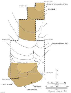
The Beech Ridge site was situated on a narrow and eroded terrace landform about 250 m north of Naconiche Creek and 100 m north of the Tallow Grove site. The site was occupied almost exclusively by prehistoric Caddo peoples sometime between A.D. 1250-1430, and it was generally contemporaneous with the nearby Tallow Grove.
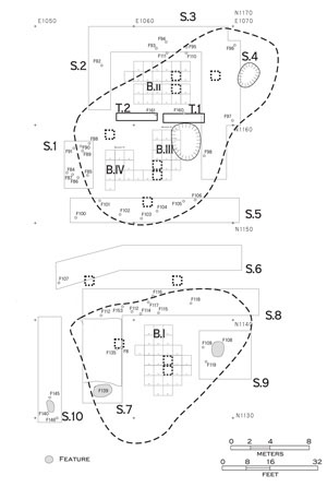
Work proceeded to do work at Beech Ridge in the same sequence as the investigations at the Tallow Grove site. The work began with (1) remote sensing, (2) intensive shovel testing, followed by (3) the excavation of a series of 1 x 1 m units to sample the archeological deposits, (4) the further expansion of particularly productive 1 x 1 m units into block excavations of different sizes, and finally (5) the use of machinery to strip and trench areas around the various block excavations to search for archeological features and other important archeological deposits.
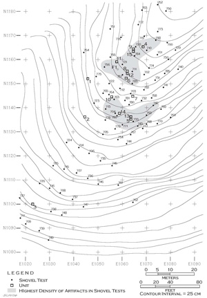
The remote sensing effort at the Beech Ridge site covered 3400 square meters on the terrace landform, a bit more than 0.8 acres. This same area was intensively shovel tested, with a total of 100 shovel tests providing very detailed shovel test coverage. The distribution of positive shovel tests indicates that prehistoric Caddo archeological deposits primarily cover about a 50-x-30 meter area.
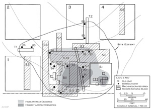
Plotting the shovel tests with the highest densities of prehistoric artifacts, two distinct clusters were defined in the northern part of the Beech Ridge site; shovel tests in these clusters had artifact densities that range from ca. 48-100 artifacts per square meter. These two spatially distinct artifact clusters were formally designated as the northern and southern "principal occupation areas" to highlight the fact that scattered occupational evidence occurred elsewhere on the site. These areas with concentrated occupational evidence are referred to below as simply the northern and southern areas.
Based on the results of the remote sensing and shovel testing, 15 1 x 1m units were placed in various areas across the site. These units were placed within the two spatially distinct concentrations of artifacts detected in the shovel testing and anomalies apparent in the remote sensing work. The backhoe trenches were excavated to clarify the stratigraphic relationships between the three blocksin the northern area.
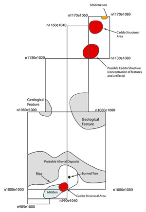
The areas with the highest densities of artifacts corresponded closely to the locations of prehistoric Caddo structural deposits, falling primarily within (or just outside to the east of) the structural deposits themselves. Rather than moving and depositing the refuse generated from their activities in middens, the occupants of these residences preferred to drop them into pits they created right outside their structures. In the parlance of archeologists, this refuse was “feature-centered” within and around small and large pit features. So, it can be inferred that the residues found in those deposits were directly related to activities that took place in the immediate vicinity. Since there were no midden accumulations on the site, it is doubtful that the Beech Ridge site was used by the Caddo for any great length of time.
Beech Ridge Features
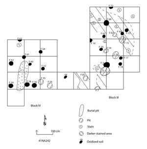
More cultural features (n=153) were identified and documented at the Beech Ridge site than at any other Lake Naconiche site. These included postholes and hearths from the remnants of three different structures in the northern and southern occupational areas, several large and small pit features, as well as two burials.
Radiocarbon dates from the two occupational areas at the Beech Ridge site indicate that these were contemporaneous. The most reasonable range of the calibrated radiocarbon dates from features in the Beech Ridge site range from A.D. 1340-1430. Postholes dug during this time period were by far the most common type of feature. These postholes appear to be part of three separate structures, two in the northern area and one structure in the southern that appears to have been rebuilt and used on at least two occasions.
Beginning with the southern area, features in Block I and surrounding machine-scraped areas were in a 12 x 12 m circular area with a considerable number of postholes (more than might be expected if they were from outdoor racks or platforms) representing evidence for rebuilt and reused structures. There was also one large pit, probably first used for storage (Feature 2), a number of small basin-shaped pits (of uncertain function), and several nearby outdoor work areas.
There were large but relatively scattered charcoal-stained areas in the Block I excavations around Feature 2, and extending outward as much as 3 m distant from this large pit. These probably represent accumulations of organic debris on the floor of a domestic structure, where they were preserved because they were located inside the protected confines of the house walls. Similar areas of darker-stained sediments were also present in the Block II and Block III/IV structural area excavations, especially in the latter. The shape of the darker stained areas in Blocks III/IV suggests these organically-stained deposits accumulated right up along the walls of a circular structure, while they accumulated next to the hearth in Block II (and possibly represent the remnants of materials raked out of the hearth during its use) and in areas to the south and northwest that probably were near the structure walls.
The same kinds of features identified and excavated in the southern area were present in the northern area: many postholes, a few large basin-shaped pits, and small basin-shaped pits (especially in the Block III/IV area). The area of structural deposits in Block II had a hearth basin (Feature 10), while no hearths have been identified in either the Block I or Block III/IV excavations. There was one extended burial in Block III/IV, probably situated just outside the walls of a structure.
Beech Ridge Postholes
The postholes from the Beech Ridge site fall into two groups. The first, with a mean diameter of around 20 cm, are wall support-sized posts or posts used for the construction of ancillary facilities, either inside or outside of structures (i.e., racks, screens, or dividers). They were oval-shaped with sloping sides and generally rounded bottoms, with a dark brown sandy loam fill, and very rarely contain any trash or artifacts.
There were a number of larger postholes. These held larger wood poles, as their mean diameter was around 28 cm. Several of the larger posts appear to be roof support posts, such as Features 37 and 44 in Block II and Features 56 and 66 in Block III/IV. The circular structures probably had either two or four roof support posts at any one time, but they certainly could have been replaced and reused, and perhaps re-set in slightly different locations thru time. No obvious interior support posts were evident in Block I, although there were four somewhat larger (around 25 cm in diameter) posthole features that may have served as supports.
One larger posthole, Feature 71, was found underneath the Feature 10 hearth in the Block II structure excavations. This is apparently the center post to the structure in this block that was cut out after the wall support posts had been bent and tied together at the apex of the roof.
Other larger postholes that occur outside the context of domestic structures (such as Features 143 and 149 in the southern area and Features 86 and 94 in the northern area) may have been used to anchor more substantial outdoor facilities, perhaps work platforms or ramadas. These larger posts tend to occur amidst other features, typically small basin-shaped pits that were widely distributed outside the Beech Ridge structure areas.
Beech Ridge Hearths, Basins and Pits
One basin-shaped hearth was discovered in Block II. It is a central hearth (Feature 10) of a Caddo house, and it had a central post (Feature 71) hole preserved under it. There were five smaller postholes (17-19 cm in diameter) arranged around and near to the hearth, suggesting there may have been a screen or divider around three sides of the hearth to restrict access or to shield the fire from the occupants of the structure.
This hearth was approximately 130 x 145 cm with sloping sides and a relatively flat bottom. It had a dark brown to very dark brown fill with charcoal and bone flecks; the underlying Feature 71 post became visible in plan at the base of the hearth when the hearth’s fill was removed. This fill surrounds two large patches of oxidized soil on the northern and protected side of the hearth.
At Beech Ridge, small basin-shaped pits are quite common, 41 were identified during the excavations. These pits are thought to represent small cooking and heating features, as well as smudge pits used to create smoking fires, and they occur in both outdoor working areas as well as within structures. The pits generally had organically-rich and dark brown to very dark brown charcoal-stained sandy loam fills, although typically they do not contain many artifacts. None of these small pits had oxidized areas or baked walls or floors.
Small pits were documented in all three excavation areas (Blocks I, II, and III/IV) where structural evidence was present. These were found within the structures, along the apparent walls, and in nearby outdoor areas where a variety of domestic activities would have taken place.
There were three small basin-shaped pits (Features 3, 53, and 102) that stand out from the others with respect to their size and volume; one of these is in the Block III/IV excavations and inside the area of a structure, another is in an outdoor work area south of this block, while the third (Feature 53) is inside the area of Block I structural deposits. These small pits have volumes that range from 3.6-5.0 bushels, more than two standard deviations above the mean range of all the other small basin-shaped pits. These features were otherwise indistinguishable from the remainder of the small pits found at the Beech Ridge site.
There were six large basin-shaped pits on the site, two (Features 4 and 11) in the northern occupational area, both apparently within structures (or areas with habitation debris, hearths, and an abundant number of postholes, more than would be expected in an outdoor work area), and four in the southern area (Features 2, 108, 127, and 139). The mean pit volume (in bushels) for these large pits is 10.12 ± 3.72, with a range from 4.7-19.2 bushels.
By volume, the large pits in the northern area could have held 15 bushels (380 kg) of plant foodstuffs between them, large enough to hold a year’s supply of maize for at least six people whose diet was somewhat dependent (an estimated 30% of the diet) on this domesticated plant. In the southern area, large pit volumes ranged from nearly 5 to just over 19 bushels. Together, these four large pits could have held over 45 bushels (1200 kg) of maize or other important foodstuffs, enough to feed a family of five that had some reliance on maize for at least three years.
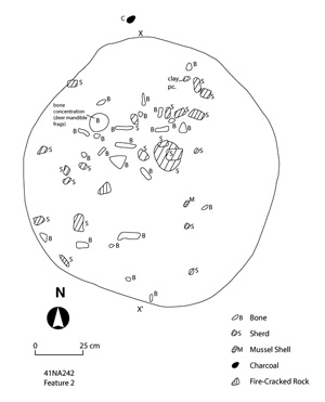
Feature 2 is the largest and most impressive of the basin-shaped pits at the site. It measures 160 x 135 cm with rounded sides and a flat bottom. Estimated volume of the pit is a little over 19 bushels (475 kg). The pit had a dark brown to very dark brown sandy loam fill with several patches of black charcoal-stained sediments. The fill contains an abundance of animal bones, mussel shell (among them a perforated mussel shell), including deer mandible fragments, many pottery sherds (among them a substantial basal portion of one vessel), lithic debris, and burned clay/daub.
The large pits are thought to represent at least three different episodes of use associated with the Block I structural deposits. New large pits used for storage seem to have been serially dug by the Caddo occupants as the old ones were no longer serviceable or too much trouble to maintain. After Feature 2 was abandoned and filled with trash, there would not have been enough room inside the apparent structure it is found within to accommodate another large pit feature, so new large pit features (Features 108 and 139) were dug outside the structure's walls.
Based on the larger amount of trash, including animal bones and charred plant remains in Feature 108 compared to Feature 139, it is suspected that Feature 139 was the last large basin-shaped pit to be used by the Caddo occupants of the southern part of the Beech Ridge site.
Feature 127 also had sloping walls, but a rounded bottom. Its estimated volume is nearly 5 bushels (about 118 kg). The feature sediments were a dark brown sandy loam with two lens of charcoal staining (implying two episodes of trash disposal).
The large basin-shaped pit feature east of the Block I structural deposits (Feature 108)—and thus situated in an outdoor work area—is 154 x 120 cm , and 25 cm thick, with rounded pit walls and a sloping floor. Its estimated volume is nearly 10 bushels (almost 250 kg of foodstuffs). The feature fill is a dark brown sandy loam with charcoal and bone flecking, as well as ceramic sherds, animal bones (among them two deer mandible fragments), and mussel shell.
Feature 139 is southwest of the Block I/Scrape 7 structural area. It could have held 12 bushels of foodstuffs in its 144 x 102 x 33 cm long, wide, and deep pit. Most of the pit fill is a very dark brown sandy loam with bone and charcoal flecking, but there is a distinctive fill zone (Feature 139A) that was a very dark to black sandy loam in the central and lower part of the pit. Artifacts recovered in the pit include lithic debris, FCR, numerous decorated and plain ceramic sherds, animal bone, and charred plant remains.
Both of the large basin-shaped pits in the northern occupational area were inside the area of structural deposits. Feature 11 is about 2 m northeast of the central hearth in the Block II structural deposits, while Feature 4 appears to be located along the eastern side of the area with prehistoric Caddo structural deposits in Blocks III and IV. Feature 4 could have held approximately 5 bushels (118 kg) and Feature 11 held nearly 11 bushels ( 265 kg). Both large pits have dark brown sandy loam fills with charcoal and/or bone flecking. Feature 4 contained very little trash before it was filled in, while Feature 11 had lithic debris, a number of plain and decorated ceramic sherds, burned clay/daub, and a FCR, as well as discarded plant and animal remains.
Beech Ridge Ground Stone Tools
There is one ground stone tool concentration (Feature 92) in the northern area. These tools, including a polished axe or gouge fragment, two manos, and three mano/pitted stones, were apparently cached in a small pit (38 x 59 cm) some meters west of the Block II structure. The fact that there were only very limited pre-A.D. 1200 archeological materials on the Beech Ridge site strongly suggests that this tool cache is part of the Middle Caddo period occupation.
Beech Ridge Burials
There were two burials at the Beech Ridge site: Feature 1 and Feature 140. Feature 1 is in the northern area, while Feature 140 is in the southern area. Feature 1 had been discovered during the 1999 archeological survey at Lake Naconiche.
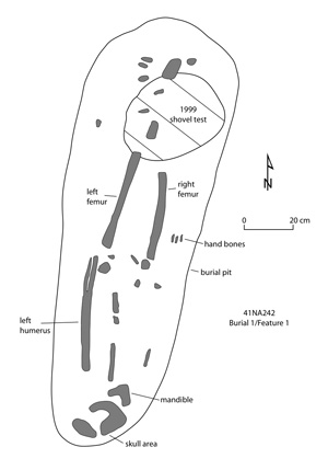
Feature 1 is the burial of an adult male at least 21 years of age at death, laid in the burial pit in an extended position, with the head at the southern end of the grave. There were no associated funerary offerings with this individual. The human skeletal remains were poorly preserved, although portions of the skull, legs, hand bones, left arm, and mandible were identifiable in the grave pit. The burial may have been placed just outside the structure identified in the Block III/IV excavations.
The Feature 1 burial pit is 174 x 59 cm, tapering in width near the skull, and was shallowly buried. Its north-south burial orientation is not an orientation for burial seen among modern Caddo Indian peoples, as discussed above for a similarly oriented burial at the Tallow Grove site (Feature 65).
The second burial feature (Feature 140) had no preserved skeletal remains, which was also the case with several of the burials at Tallow Grove, certainly because of the highly acidic nature of the sandy loam deposits on the landform. There were also no funerary offerings with this burial. The burial is several meters west of the Block I habitation debris and structural remains. The burial pit is 123 x 53 cm, with rounded corners. Since the graves of adults buried at both Beech Ridge and Tallow Grove were between 167-192 cm in length, the smaller size of this pit suggests that a Caddo child, or juvenile, was interred in this grave.
Summary of Beech Ridge Site Features
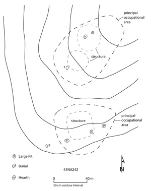
The Middle Caddo period occupation at the Beech Ridge site had two principal occupational areas at the northern and southern parts of the landform. Both areas had apparent structures, as well as indoor and outdoor pit features and activity areas around them. These activity areas were located north, south, and west of the structural areas, but did not encircle them. There was an open area—a plaza, common area, or courtyard—that separated the two occupational areas of domestic households and contained little of archeological consequence.
The prehistoric occupation at the Beech Ridge site was not particularly intensive or long-lasting, probably 20-40 years in maximum duration. This is based primarily on the relatively low density of artifacts, the absence of midden deposits, the occurrence of only six large basin-shaped storage pits, and the lack of a formal cemetery. The two burials were situated west of the structures, and in one case (Feature 140) a burial was placed well-removed from the domestic household.
The Tallow Grove and the Beech Ridge sites are regarded as the most important of the sites the team excavated. They were only 100 meters apart, so they were probably both a part of a single community. They were the best preserved sites, had the best features and evidence of structures—all the things archeologists look for to reconstruct what a Caddo village or hamlet looks like. Taken together, the two sites give archeologists a nice view of what rural Caddo life was like in the area about 600 years ago, something unknown before the investigation.
This combined Tallow Grove-Beech Ridge site represents the most intensive occupation of all of the sites investigated at Lake Naconiche. Why one site among a contemporaneous group of sites was more intensively used than the others is unknown. We simply do not know the Caddo “rules” for choosing sites for settlement, or when they were to be abandoned.
Although Tallow Grove and Beech Ridge were discovered during the initial survey of Lake Naconiche, because of the burials discovered there work was halted immediately. Five years would lapse before archeologists were allowed to return to do further research. The team wished they had been able to work on these two sites earlier because there was much more research that could have been done at the sites. Today most archeology in the United States is done by consulting firms. Archeology is a business and the team had to negotiate a reasonable budget. Invariably, there is never enough money to completely excavate a site and good archeology sometimes gets destroyed or uninvestigated. As lead investigator Perttula put it, "it is incredibly frustrating to know you can only do just so much research and that the site is going to be bulldozed away when there is still good Caddo archeology to be had. We had to start from scratch, but it turned out the Tallow Grove and Beech Ridge excavations provided some of the most interesting results we could have hoped from an excavation in this area of Texas."
The Foggy Fork, Boyette, and Naconiche Creek sites were smaller and less intensively used than the Tallow Grove and Beech Ridge sites.
Foggy Fork Site (41NA235)
The Foggy Fork site was a well-preserved habitation locale estimated to cover about 1.2 acres. It had a maximum of 50-60 cm of archeological deposits on a low toe slope landform overlooking the Naconiche Creek floodplain. An intermittent tributary to Naconiche Creek lay about 25 m to the west, and a modern pipeline right-of-way immediately to the south of the site. Radiocarbon and OCR dates indicate that Foggy Fork was occupied by Caddo peoples in the first half of the 15th century A.D. The main Late Caddo occupation at the site covers a ca. 1400 square meter area (0.35 acres) on the southern part of the slope.
Block I in the eastern half of the site measured 9 x 9 m . No cultural features were defined in Block I at the Foggy Fork site during the data recovery work. One posthole had been identified during the test excavations, however. The artifacts from Block I were dominated by plain and decorated ceramic vessel sherds, with lesser amounts of lithic debris, fire-cracked rock and burned clay/daub pieces, as well as chipped and ground stone tools.
The remainder of the Foggy Fork site both north and west of Block I was investigated by a combination of machine scrapes, backhoe trenches, 50-x-50 cm units, additional block excavations, and remote sensing. Within the site as a whole, the highest artifact densities occurred throughout the eastern half of Block II—both inside and outside Structure 1—and in areas to the east of Structure 1. Once beyond 5 m away from the structure, artifact densities tapered off.
Over 97% of the 32 cultural features excavated at the Foggy Fork site were found either in Block II or in immediately adjacent machine-scraped areas. These features were all related to the construction and use of a circular Caddo structure occupied in the 15th century A.D. This structure was very similar to, and roughly contemporaneous with, structures found at Tallow Grove and Beech Ridge. The features included 24 postholes, two small pits, one large basin-shaped pit, two hearths, and one pottery sherd concentration.
Structure 1 was marked by an arc of 14 postholes that were wall posts. There were six smaller postholes inside the structure—and partially encircling Feature 2—that may either mark the construction of a cane-covered screen or divider within the structure itself or served as interior roof supports. The entrance to the structure may have been along its east side, probably marked by Features 4 and 6 facing towards Block I, based on their larger size (27-31 cm in diameter) compared to the size of the other exterior wall posts. There were also three postholes (18-19 cm in diameter) just outside the southern and eastern walls of the structure; their purpose is unknown, but screens, racks, or other outdoor facilities would certainly be expected to have been built near a Caddo house.
The postholes within the structure were about the same size as the exterior wall posts (19-21 cm). Features 9, 20, and 25, however, were only 12-17 cm in diameter as well as shallower in depth, suggesting their use in poorly preserved screens or other dividers. One of the interior posts (Feature 22) contained charred nutshells which were radiocarbon dated to between A.D. 1400-1460 (2 sigma, calibrated range).
Two large features were within Structure 1, a large basin-shaped pit (Feature 2) and a hearth (Feature 8). Feature 2 is a storage pit that was eventually filled with trash, including discarded sherds, animal bones, and charred plant remains. This pit is approximately 1 m in diameter. It would have held approximately 0.41 cubic meter of storage space, sufficient volume to have stored around 12 bushels of foodstuffs.
The fill in Feature 2 was a homogeneous very dark brown sandy loam with no zoning or separate strata within it, suggesting that it was filled rapidly over a short period of time. There were significant amounts of charred hickory nutshells in the feature fill, along with charcoal chunks. Three radiocarbon dates on nutshell have produced calibrated radiocarbon dates that range at two sigma from A.D. 1310-1650, but with calibrated intercepts that date from A.D. 1420-1480.
The hearth inside Structure 1 covered an approximately 85 x 96 cm area of dark brown sandy loam that was mottled with a brownish-yellow sand. The hearth was in a basin. Charred nutshells in the hearth date from A.D. 1300-1460. There were large chunks and lumps of burned clay and oxidized sand within the fill of the hearth. These may either be remnants of a baked hearth lining or the remains of heating and cooking activities within the hearth basin that burned exposed patches of dirt and sediments around it.
Two 20 cm posthole stains (Features 8A and 8B) were visible underneath the hearths, but they seemingly cannot be evidence for the use of center posts since the hearth is not centrally located within Structure 1. It is hard to conceive how posts offset from the center line of a structure would have been much use in the initial construction and raising of the structure walls. Perhaps they did help support the raising of the structure walls in some secondary way, or represent the remnants of postholes (for a screen or cooking rack) that originated above the hearth but were not visible in its feature fill.
The postholes along the Structure 1 exterior wall were generally about the same diameter (between 17-23 cm, with a mean of about 19 cm) and depth, indicating the use of wall post timbers about the same size and age. As previously mentioned, Features 4 and 6 were larger and deeper, as is Feature 12 (33 cm in diameter), and their larger size (mean of 30-32 cm) may have been a construction feature associated with marking the entrance into the structure or strengthening the eastern structure wall with larger timber posts.
Two features occurred to the north and outside Structure 1. One was a medium-sized basin-shaped pit (Feature 17) about 2.5 m north of Structure 1 and the other appears to have been a hearth (Feature 18) about 1 m in diameter. Feature 17 is about 1.1 m in diameter. The pit was 0.24 cubic meters in volume, enough room to have stored approximately seven bushels of plant foods. Feature 18 had a black to dark gray sandy loam fill, with ash and charcoal flecking, and the eastern part of the hearth basin had been well-heated, oxidized, and baked hard from having contained a fire.
In summary, the Foggy Fork site appears to have been a small Late Caddo farmstead dating to the early 1400s. A circular house, Structure 1, was over 8 m in diameter and had a small midden nearby. In around the house and midden areas were a range of domestic features including storage pits and hearths, as well as various postholes representing related outside features such as drying rack.
Boyette Site (41NA285)
The Boyette site is situated on the tip of a narrow and thickly wooded upland ridge, toe slope, and small alluvial terrace about 125 m south of Telesco Creek. In the heart of the site area, the landform is about 2 m above the Telesco Creek floodplain. The site covers approximately 4800 square meters, or 1.2 acres.
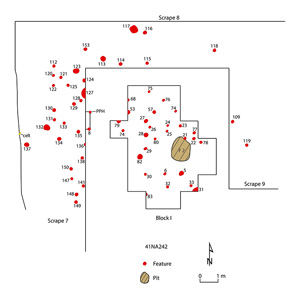
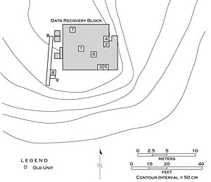
Data recovery excavations at the Boyette site took place in two blocks. Block I is a contiguous 14 x 9 m block in the main site area. In order to define a possible house area, a roughly 24 square meter area (Block I extension) was shovel- and trowel-scraped along the western edge of the block. Block II at the Boyette site is about 10 m to the northeast of the northeast corner of Block I.
Like the Foggy Fork site, the Boyette site had clear evidence of inhabited structures and many interesting pit features. Twelve cultural features and three possible features were defined in the main portion of Block I. The western extension of the block contained a clear posthole feature and 27 probable cultural features that apparently delimit the western one-half of a house structure that probably extended into the western one-half of Block I.
Numerous features (n=48) were identified and documented in Block II, including postholes from two periods of structure construction and use, pits, two impressive and sequent hearths (Features 3A and 36) within the area of those structures, and a single burial (Feature 13A). Radiocarbon analysis indicates that the features date from Late Archaic, Woodland, Early Caddo, and Middle Caddo period times. The great majority of the features date to the latter part of the Woodland period and the Formative Caddo period, namely the time period between A.D. 670-1075.
One of the highlights of the Boyette site illustrates an unusual aspect of Caddo hearth use. The archeologists were surprised to discover that a second basin hearth almost directly underlies Feature 3A. This hearth (Feature 36) is smaller, 74 x 82 cm, and was a basin with sloping sides and a flat bottom. This second hearth had a dark brown sandy loam fill with abundant chunks of charcoal and charred nutshell. A calibrated radiocarbon date on nutshell has a calibrated age range of A.D. 710-980, as little as 20 years older than the overlying Feature 3A hearth (A.D. 790-1000). One area of the basin had heat-altered and charcoal-stained fills. No center post immediately underlies this hearth.
In other words, here we have a house with a basin feature that the inhabitants abandoned, or burned down, then later, they built another one right on top of it. Usually that implies a longer occupation, but why didn’t the Caddo use the hearth that was already there? The hearths were almost exactly on top of each other—the occupants had to have known this—there was very little soil atop the first hearth. We infer that it may have only been a couple of years since the house had been last used. The place had been abandoned, but not for long before people came back a few years later and occupied the same place.
Posthole features found at Boyette were fairly typical in shape and size for domestic structures found at prehistoric Caddo sites in northeast Texas. The few larger postholes, those more than 25 cm in diameter may mark roof support posts around the hearths (i.e., Feature 26), center posts under hearths (i.e., Features 29), or other posts used for other purposes than wall support posts (i.e., Feature 34), perhaps as a burial marker. One large storage pit found at the site (Feature 2) would have held nearly 8 bushels of plant foods (volume equaling 0.25 cubic meters). It is at least twice as large as any of the other small pits found at Boyette.
One of the two burials found at Boyette (Feature 13A) is that of an adult female (25-35 years of age at death). The woman was laid on her back in the grave pit, with her feet at the west end and her head at the east. The female's grave is oriented southeast-northwest, with the individual’s head facing almost due north, probably because the skull rotated to the side sometime after the burial itself. A calibrated radiocarbon date retained from a tiny sample of bone from this individual has an age range of A.D. 1290-1410. This burial may have marked nearly the last use of the Boyette site by its Caddo occupants. The interment was generally contemporaneous with an infant burial found in Feature 1/10 in Block I.
A single funerary offering was placed with this woman. This is a Holly Fine Engraved globular bowl placed just south of the skull and above her left shoulder.
Once the various features in the block were recognized and defined, it was noted that two postholes (Features 34 and 37) and one small pit (Feature 10) intersect the walls of the burial pit. One of those features, the Feature 34 post, may be associated with the burial pit as a post marker, while Feature 37 cut across the burial and post-dates the burial. Feature 10 also crosscuts and thus post-dates the burial.
Naconiche Creek Site (41NA236)
The Naconiche Creek site lies on a small wooded rise about 175 m north of Naconiche Creek. It is in the area of the spillway for Lake Naconiche, and the rise covers about 0.3 acres. Survey investigations at the site indicated that it had a midden deposit (about 50 cm thick) that contained Late Caddo pottery sherds and relatively well-preserved animal bones and charred plant remains. There were also deeper archeological deposits below the midden that related to an earlier Woodland period occupation on the rise.
Twenty-six cultural features and seven probable cultural features were defined at the Naconiche Creek site. The cultural features occur throughout the block but were most concentrated in a roughly linear east-west swath that cuts through the center of the block.
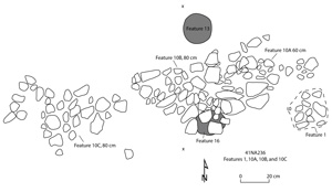
Cultural features include 10 postholes, five small pit features, one large pit feature or midden (Feature 18), two sherd concentrations (Features 21 and 22), a rock-filled pit (Feature 1), and seven concentrations of burned and unburned rocks (Feature 8 and Features 10A-10F); Feature 8 also contains several sherds.
The Naconiche Creek site proved to have the oldest dated deposits encountered in the investigated sites in the project area as well as clear evidence of reoccupations of the site over a span of perhaps 4,000 years. Calibrated radiocarbon dates of 2930-2880 B.C. (Feature 13), A.D. 90-260 (Feature 17), A.D. 410-600 (Feature 4), A.D. 430-780 (Feature 5), A.D. 570-770 (Feature 18), A.D. 720-1010 (Feature 3), A.D. 710-1170 (Feature 19), and A.D. 1410-1470 (Feature 8) have been obtained from different features.
Features 10A-10F consist of six roughly linear (5.5 m), albeit discontinuous, concentrations of ferruginous sandstone and conglomerate rocks (including plinthite, an iron-rich, humus-poor mixture of clay with quartz and other minerals) that, along with Feature 1, bisects the center of the excavation block. Feature 10A overlaps the eastern extent of Feature 10B. These rock concentrations were encountered immediately below the midden and included the occasional sherd or piece of lithic debris. These were likely cast-offs from the cooking process, “used-up” rocks that were tossed out of a cooking feature. These rocks pre-date the Caddo occupation (the Caddo did not do much hot rock cooking) and are mostly likely associated with the underlying Woodland deposits.
|