Investigations |
||||||||||||||||||||||
|
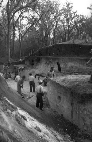
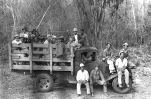
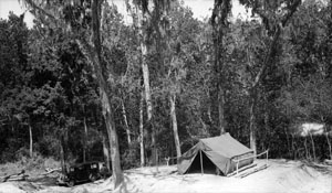
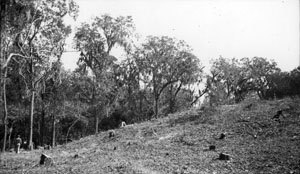
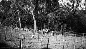
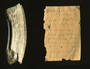
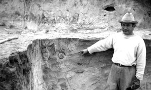
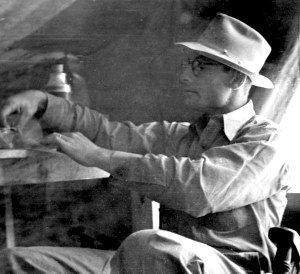
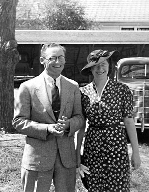
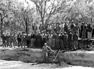
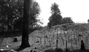
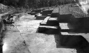
Morhiss Mound was first described in 1883 by the Victor M. Rose, an historian and the editor of Laredo Daily Times in a book on the early history of Victoria. Although the mounds height and size must be exaggerated, the write left little doubt that he considered it an artificial construction. "The Mound," an immense semi-cone shaped accumulation of earth, rising above the level alluvial deposits of the river to the height of 100 feet, is a curiousity. It is situated six miles south of the city of Victoria, on the east bank of the river, and is included in the farm of Mr. Morhis, who has erected upon the surface, which embraces an area of several acres, a house, and planted a peach orchard. [A similar mound, the "Peach knoll," is mentioned as being farther down river on the opposite bank.] These are identical with the works of mound-builders ... which have been partially explored in some states in the Mississippi Valley, yielding specimens of ancient pottery, skeletons, etc. Victor M. Rose, 1883 Archeologists may have first learned of the Morhiss site in 1930 when A.T. Jackson of the University of Texas was told about a peculiarly large earthen mound along the Guadalupe River near Victoria. Two years later, in May 1932, he attempted to visit the site and was unable to do so because it was surrounded by the then-typical late spring floodwaters that inundated much of the low-lying parts of the Guadalupe River valley. (Such floods are less frequent today due to the upstream Canyon Reservoir.) A month later, in early June, Jackson and two field assistants were able to reach the site, which was a large, tree-shrouded earthen mound measuring roughly 300-x-400’ and 20’ high. They spent three days digging two small trenches on one side of the mound, finding much evidence of human occupation. Echoing Victor Rose, Jackson formed the opinion that the large mound was built by prehistoric peoples, making it the only mound site known between east Texas and northeastern Mexico and a most important site. At the time, Jackson was the field director of a statewide archeological survey program at the University of Texas under Professor James E. Pearce. Pearce had begun the program in the mid-1920s, which was expanded in the early 1930s with modest funding from the National Research Council. Jackson, a former newspaper reporter, became Pearce’s right-hand man and led small crews to prominent sites across the state from Caddoan village sites in the Pineywoods of east Texas to the dry caves of the Lower Pecos in southwest Texas. By 1932, federal funding enabled Pearce and Jackson to hire assistant archeologists and send out several crews in different parts of the state. His three-day work session at the Morhiss Mound was, in fact, a scouting and planning mission. A week later Jackson’s assistant, A. M. Woolsey, arrived at the site with a crew of four college students. They spent three weeks continuing Jackson’s trenches and starting two other trenches. This second phase of work resulted in the excavation of a combined trench 4 feet wide and 160 feet long across an end of the site. They dug down to as deep as 11 feet, finding artifacts throughout a thick upper layer of “black sandy loam” which capped deeply buried layers of sandy clay and “white chalky clay.” Woolsey’s short unpublished manuscript on his work focuses mainly on ten human burials that were encountered at various depths. These were each carefully exposed, photographed, and individually described. Other finds of complete artifacts (22 of which were listed), Ice-Age fossils, and the mound’s layering (stratigraphy) were mentioned without much understanding or detail. There are no surviving photographs of the 1932 work and only minimal documentation, most of it relating to the burials. The 1932 work showed that the knoll began as a natural remnant of a Pleistocene river terrace, but Jackson and Woolsey believed that the thick dark layer that covered the mound had been purposefully added. They speculated that the black sandy loam had probably been obtained from a nearby depression where dark soil was also present. This topographic feature is visible in the aerial photos and is an obvious abandoned river channel filled-in with dark, organic rich sediment superficially resembling the dark layer capping the mound. The presence of numerous artifacts within the mound’s black sandy loam was interpreted as evidence that the seemingly homogenous layer was artificially added, rather than a massive cultural deposit formed by gradual accumulation over thousands of years. At the time, little was known about the age and stylistic variations of stone tools. Woolsey did realize that the site must contain many more burials. By the mid-1930s larger Federal programs, especially the make-work Works Progress Administration (WPA) provided unprecedented amounts of funding for archeological projects in many areas of the country. Unemployed workers were put to work carrying out excavations under the direction of trained archeologists associated with major universities. A.T. Jackson at the University of Texas oversaw many WPA projects between 1935 and 1940. Large-scale excavations were undertaken at new sites and in new areas of the state as well as known sites such as the Morhiss Mound. Between October 1938 and January 1940 archeologist William A. Duffen and a large team of 30-40 WPA-paid workers succeeded in completely removing essentially all occupational deposits associated with the site and the terrace remnant. The entire site was laid out in a grid containing as many 5000 five-foot squares that served as excavation units, each square given a unique alpha-numeric code. During the 16-month excavation, most or all of the squares were excavated to various depths. Vertically, the site was excavated in 5-foot “terraces” that the workers followed, square by square, across the site. These were essentially what archeologists call “arbitrary levels,” but those used today typically range from only 5 cm to 20 cm thick in order to maintain tight vertical control. The system used in the WPA excavations at Morhiss was adapted from similar strategies used at many of the WPA projects overseen by Jackson. The system seems crude to archeologists today, but it was a reasonable compromise for the day that allowed minimally skilled workers to carry out large-scale systematic excavations. It was also a vast improvement over the methods used during the Pearce-led era of the 1920s and early 1930s. Three aspects of the Morhiss site can be said to have been the major research goals of the WPA investigations: the Archaic cemetery, the Pleistocene fossil bones and their possible association with Early Man, and the origin of the "mound" topography. These goals and the evidence they yielded are covered in the Evidence section, but here is how they impacted the investigations. Over 200 burials were carefully exposed and systematically documented, a vast improvement over cemetery excavations of earlier days. Although most of the Morhiss excavations were done by pick and shovel, the workers were watching for human bones and the most skilled excavators were called in to do the detailed work. Unfortunately, we do not have any surviving photos or much discussion of the methods. But we can tell from the final documentation photographs of the individual burials that they were excavated by trowel and whisk broom by skilled excavators. The archeologists were interested in the burial practices and associated grave goods, and how these may have changed through time. They also hoped the skeletal remains would prove informative to physical anthropologists. Who were the people buried at Morhiss Mound? How did they relate to historic Indian peoples and to other prehistoric remains? The human remains have been examined by several physical anthropologists and bioarcheologists through the years and were the subject of a recent dissertation by Helen Dockall at Texas A&M University. Ongoing analyses are also being carried out by other researchers. The fossilized bones of extinct animals that were found in the lower, pre-midden layers of the mound attracted considerable attention. Ice-Age animals were interesting in and of themselves as relicts of a bygone colder era, but the archeologists had a particular angle. Did Early Man, the term used for the early inhabitants of North American whom we call Paleoindian peoples today, coexist with the now-extinct beasts? In the mid-1930s suggestive evidence of the association of fossil bones and ancient artifacts had been found along the Berclair Terrace not far to the west in Bee County by the Texas Memorial Museum (TMM). The first TMM director, E. H. Sellards, was a paleontologist who had taken on the investigation of Early Man sites as his own research focus. In fact, while the WPA work at Morhiss was underway, the TMM carried out a smaller WPA excavation project at the Buckner Ranch site along the Berclair Terrace (see Buckner Ranch). During this period, Sellards visited the Morhiss excavations and encouraged Duffen to seek evidence of fossil bones and artifacts found together. In the end, only meager and doubtful evidence of such an association was found, but the WPA crews spent a fair amount of time looking and collecting fossils. The question of whether the mound was a purposeful construction was very much a major topic of interest. To Jackson’s credit, he seems to have sent Duffen to the field with the freedom to consider the question anew. To understand how the site formed, Duffen approached the mound from one direction and dug the squares side-by-side, so that a series of sections or profiles through the mound could be studied and documented. He produced a series of measured drawings and photographs of these exposures, not all of which have survived. And he answered the question, as we shall see in the next section. Although there are apparent gaps in the surviving WPA records, a considerable amount of information is preserved in the TARL archives including summary quarterly progress reports, a topographic map, a schematic stratigraphic section drawing, numerous black and white field photographs, systematic sets of feature and burial records,and artifact documents such as inventories, classifications, descriptions, photographs, and drawings. When this exhibit on Morhiss Mound was first published in September, 2006, the authors wrote "not much is known about William Duffen." Happily, that is no longer true. When he spied the TBH exhibit, a very much alive and well 99-year-old William "Bill" Duffen called from Tucson, Arizona to set us straight with several telephone interviews. Duffen did indeed have archeological training, as we surmised. He majored in archeology at the University of Arizona, where he earned his undergraduate degree and his M. A. in the early to mid-1930s. There he was trained by several of the leading scholars of the day, including Byron Cummings, the man known to students and colleagues as "The Dean" of Southwest archeology. Bill Duffen also spent a summer working for Andrew Douglas, who pioneered dendrochronology (tree-ring dating). After graduation Duffen spent a field season helping to stabilize the cliff dwellings at Tonto National Monument. In 1938 Dean Cummings recommended Duffen to "Doc" Pearce at the University of Texas who was then searching for qualified archeologists to supervise WPA projects. A telegram offer soon sent Bill and his wife to packing with "everything we owned." They soon moved to Victoria where he was put in charge of 40 workers and sent to excavate Morhiss Mound. It was a "different kind of archeology altogether" from that he had learned in the Southwest. At first Duffen kept the men busy clearing the site, removing stumps, and establishing a site grid. The WPA budget was tight so he had the men fashion flattened grid stakes from hardwood tree limbs. But then it came time to begin excavation while he simultaneous trained the workers in archeological techniques. "My tail was on fire trying to keep up," as he put it. The safety of his men was a chief concern. The site location was remote and each day required a long round trip through the brush, the men loaded into a large truck and Duffen driving his own car. Guadalupe River floods came up pretty close to the mound several times, sending rattlesnakes, copperheads, and water moccasins in search of higher ground. Periodic wet conditions resulted in the construction of a raised platform upon which the large canvas tent that served as Duffen's field office and equipment storage was placed. He recalls the deep trench they dug beneath the mound to try to establish its origins and recover Pleistocene fossils. A high water table made things "mushy at the base of the mound" and prevented Duffen from digging as deep as he would have liked. Duffen's systematic records, his WPA progress reports, and the text of a 1939 paper he presented to the Texas Archeological and Paleontologist Society (now, TAS) reveal that he was a keen observer. It was he who demonstrated that the mound was not an artificial construction, but instead had formed by natural and cultural accumulations over what he reasoned was a considerable span of time. In several places in his progress reports Duffen expresses his anticipation of preparing a thorough final report. Alas, he was never given the opportunity to do so. From Morhiss he went on to run excavations at the Yarborough site in east Texas and he took part in other excavations along the coast and the Colorado River west of Austin. Most WPA programs ended in the early years of World War II and Morhiss is one of many major WPA archeological investigations in Texas and elsewhere across the country that were never properly completed. William Duffen resigned from the WPA in 1941, intending to enlist in the army. A perforated ear drum sent him to Baltimore instead where he spent the war building planes. After the war he returned to Tucson, needing a job and soon began a second career as a high school history teacher. Although he left archeology behind him, his unfinished work with Morhiss Mound ran "through my mind all this time," as he put it on the verge of his 100th birthday. Were it not for the intervention of the war, Duffen thinks he might have stayed in archeology. "I enjoyed that work in Texas." In the succeeding six and a half decades since the field work ended at Morhiss, many archeologists have realized the site’s potential and several have tackled various parts of the daunting task of doing thorough analyses of the materials, with some success. None of these efforts has yet succeeded in carrying out comprehensive analysis, interpretation, and full reporting of the site. This would require several years of dedicated work and substantive funding so that modern analytical techniques could be used. As a way of comparison, we estimate that the modern excavation of a site similar to Morhiss Mound would take at least three years and millions of dollars, and that’s just the fieldwork. The analysis and reporting would take an additional three to five years and several million dollars. With much more sophisticated and probing research questions and state-of-the-art techniques, much more would be learned. The chances of a site like Morhiss Mound surviving mostly intact over the last 65 years are next to nil, however, so we are lucky to have what we have. The most useful overall appraisal of the site was done by the late Professor T. N. Campbell of the University of Texas at Austin in the early 1960s. Campbell reviewed the records and reclassified some of the artifacts and set forth what he explicitly noted was a preliminary and descriptive appraisal. His summary was later published as an appendix in a 1976 archeological report on the nearby Coleto Creek Reservoir (see Campbell 1976 |
|
|||||||||||||||||||||