University of Texas at Austin wordmarkUniversity of Texas at AustinCollege of Liberal Arts wordmarkCollege of Liberal Arts
Texas Beyond History
TBH Home
Plateaus and Canyonlands Main
Prehistoric Texas Main

Reading the Layers: Stratigraphy and Archeological Sequence of Kincaid Shelter

Schematic section showing the general stratigraphy of Kincaid Shelter site
The six natural zones, or strata, identified by geologists working at Kincaid Shelter. Graphic, left, by Michael Collins.
photo of archeological index
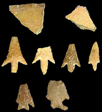
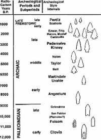
Key archeological markers at Kincaid Shelter. Artifacts from the site represent cultures spanning more than 13,000 years and include most of the Central Texas archeological periods and subperiods used by archeologists to frame and interpret site occupations. Graphic adapted from Collins 1995 and Prewitt 1981 as shown in Turner and Hester's 1993 Stone Tools of Texas Indians.
photo of mandible bone
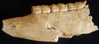
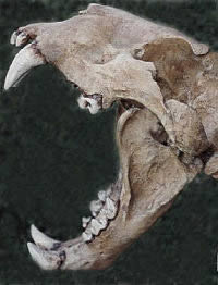
This mandible, or lower jaw, of extinct horse was found in Zone 2. The presence of three deciduous, "baby" teeth indicates the animal was a juvenile. Additional fossil horse bones were found in Zones 3 and 4. Photo by Susan Dial.
The remains of alligator and aquatic turtles in Zones 3 and 4 indicate the Sabinal was a more constantly flowing river during the Late Pleistocene period.
painting of a lion attacking a sloth
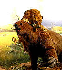
A lion attacks a giant ground sloth in this Late Pleistocene scene recreated at the La Brea Museum in California. Bones of both sloth and lion were found in Zone 3 at Kincaid Shelter, suggesting that similar scenes were played out in ancient times in the Texas Hill Country.
drawing of a sloth
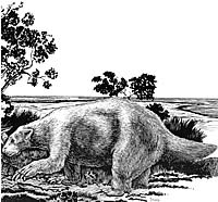
The North American ground sloth, or Mylodon. Drawing by Hal Story.
photo of carnivorous teeth
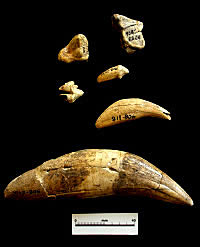
Teeth of the carnivores found at Kincaid include a massive canine from the great cave lion (Panthera atrox), shown at bottom, and dire wolf. Photo by Susan Dial.
drawing of horse
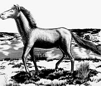
The Late Pleistocene horse, Equus sp., was by far the most abundant species in Zone 3, and is represented by more than 50 teeth, several jaws, and a few fragmentary limb bones. The extinct species was roughly the same size as the modern horse, which was introduced to North America by Spanish explorers in the 1500s. Drawing by Hal Story. Click to see full image.
drawing of a wolf
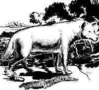
The dire wolf. Bones of this Late Pleistocene carnivore were found in Zone 3. Drawing by Hal Story.

Investigators faced a complicated problem in interpreting the deep deposits of sediment representing thousands of years of natural deposition and human activities in Kincaid Shelter. More than 10 feet (3 m) in depth, the excavated deposits spanned Late Pleistocene to recent times and represented different types of sediment accumulation, ranging from wind-blown dust and floodwater silt to ash, charcoal and rocks from campfires.

In the deeper, older zones, the excavators encountered layers of pond clay and spring-deposited travertine—reminders of the wet conditions in the cave which prompted early inhabitants to construct a rock pavement over the muddy floor. The spring, which emanated at the back of the shelter, apparently ceased to run after early Paleoindian times (after the deposition of Zone 4).

Within the deposits investigators found animal bones from both extinct and modern species and a variety of items left behind by countless generations of human occupants 
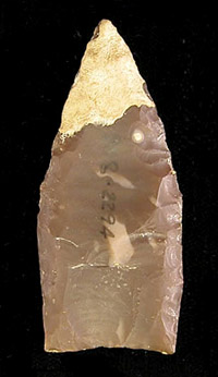
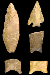
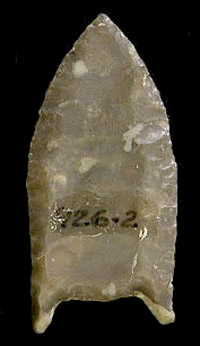
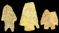
at the shelter. Among the artifacts were projectile points and other diagnostic stone tools representing almost all intervals of the Central Texas archeological sequence.

There was not, however, a clear stratigraphic ordering of diagnostic types, the time-sensitive artifacts that could be compared to those recovered from other, better dated sites. Erosion and human disturbances (both ancient and more recent) had disrupted the Kincaid deposits, mixing together many of the artifacts. More than half the artifacts recovered from Kincaid were found in the treasure-hunters' backdirt piles.

Several hearths (warming or cooking features) also were found in Zones 5 and 6, but these were not fully documented. Although there were no burials found within the shelter, investigators recovered some 60 human bones scattered within the two upper zones, representing at least four individuals. These skeletal remains were probably from burials that were disturbed by animals or later occupants of the shelter.

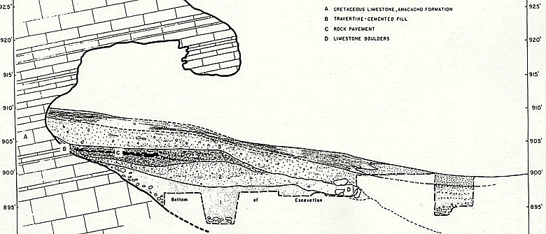
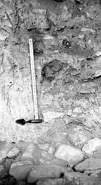
The walls of the deep trench in the center of the shelter provided a stratigraphic "profile" that helped geologists Glen Evans and E. H. Sellards classify the deposits into the various zones (stratigraphic units). These are described below, beginning with the oldest unit, Zone 1, and include a detailed look at the rock pavement constructed over Zone 3.

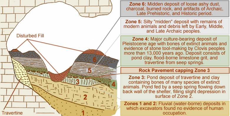
Early Non-Cultural Zones

Zone 1. Zone 1 is the lowermost unit of the shelter fill encountered during the excavations. The full thickness of this zone was penetrated only in the back and west parts of the shelter, where it was thinned out against the sloping limestone walls. One excavation square at the front edge of the shelter was dug to a depth of 14 feet (4.2 m) below the surface and penetrated 5 feet, 7 inches (1.7 m) into Zone 1 without reaching bedrock.

Zone 1 consisted of a buff-colored, floodplain silt with a few stringers (thin layers) of small, rounded limestone pebbles. Numerous spalls and blocks of limestone from the shelter walls and ceiling occurred at the base and back margin of the zone. No cultural materials or fossil animal bones were found in Zone 1.

Zone 2. This zone was a silty, river-laid deposit up to nearly 4 feet (1.2 m) in thickness. It was entirely truncated (cut out) by water erosion immediately in front of the shelter. No cultural materials were found in Zone 2, but one identifiable fossil, a partial jaw with three teeth, belonging to an extinct species of horse, Equus sp., was found in the middle part of the deposit. This zone can be assigned to the Wisconsin stage of the Pleistocene. (The Wisconsin stage was the last major glaciation period in North America, roughly 75,000 to 12,000 years ago.)

A Late-Pleistocene Menagerie

Zone 3. During the time represented in Zone 3, a small, spring-fed pond filled a low area in the center of the shelter. The bones of many types of animals—perhaps the dinner leavings of a large carnivore such as a cave lion—began to accumulate nearby. There is some, albeit scant, evidence of human occupation of the shelter during this time.

Zone 3 consisted of a ponded clay deposit containing layers of clay and fine silty clay resulting from deposition in the placid pond with intermittent episodes of flooding. The clay deposit reached a maximum thickness of 1.5 feet (46 cm) thick and occupied a shallow central depression apparently formed by high flood waters of the Sabinal River washing into the shelter. A travertine deposit (calcareous limestone formed by mineral-laden water) in the back wall extended into the clay. This deposit indicates that the pond was fed by seep springs. In the front part of the shelter, the clay deposit (Zone 3), as well as Zone 2, had been completely removed by erosion.

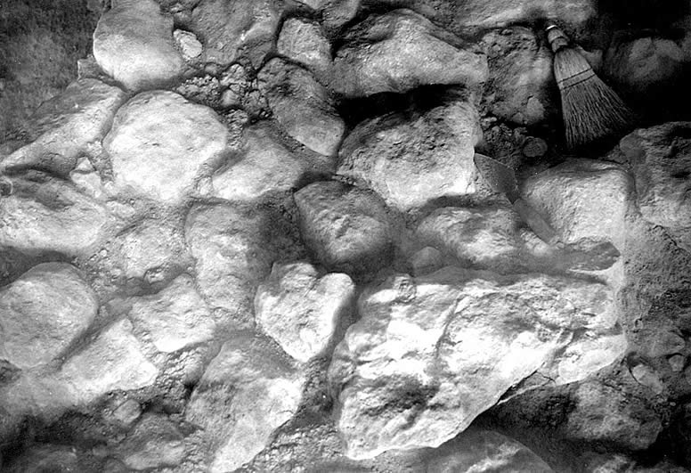
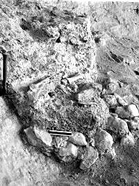
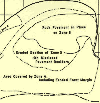
Except in the front eroded area, Zone 3 was capped by an ancient, man-made rock pavement which lay between Zones 3 and 4. Additional small patches of cobblestone pavement covering an estimated total area of 30 to 40 square feet (2.8 to 3.7 square meters) occurred in the middle portion of the zone, and were overlain by stream-deposited seams of silt and clay, which in turn, were overlain by the larger rock pavement. These intra-zonal patches of pavement will be further discussed below in a separate section dealing with the rock floor pavement.

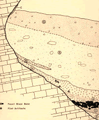
Fossil bones and teeth representing several extinct vertebrate species occurred in Zone 3, including horse, mammoth, large cat, ground sloth, camel, bison, wolf, antelope, raccoon, alligator, and two genera of aquatic turtles. Although most of the bones were badly broken and decomposed, a number of teeth, along with some jaws and other hard skeletal parts, were found in good condition. The advanced stage of decomposition seen in most of the bones suggests that they were exposed at the surface for a considerable period of time before being buried by the sediment. Quite possibly the bones were broken by man or by carnivorous animals. The most important elements that have been recognized from the fauna of Zone 3 are listed below.

The extinct great American lion (also known as cave lion), Panthera atrox, is represented by a canine tooth. Some badly decomposed foot bones of another species of Panthera, possibly P. onca, the jaguar, also were found imbedded in the clay of Zone 3, A ground sloth, Paramylodon, is represented by a broken tooth, jaw fragment, and part of one vertebra. Camel, Camelops sp., is represented by a jaw with cheek teeth of an immature individual, and by several other broken bones and teeth. Other mammals, represented by teeth and identifiable limb bones, include 
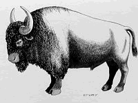
bison, a large wolf, antelope, and raccoon.

Alligator is represented by a series of articulated vertebrae and some scutes and broken limb bones. Bones of two genera of aquatic turtles, identified as Trionyx sp. and Pseudemys sp., also were found in Zone 3. The presence of alligator and aquatic turtles indicates a source of permanent water in the near vicinity, the ancient Sabinal River.

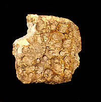
Several small patches of cobblestone pavement apparently were found at a level below the main rock floor pavement, and Evans thought these might be evidence of human 
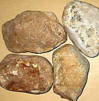
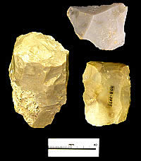
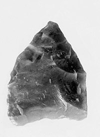
activity in Zone 3. Three thin flint flakes and a fourth thicker flake with a chipped edge also were found in this zone, but these items likely were introduced into Zone 3 during the construction of the main rock pavement.

Evans also considered the numerous animal bones in Zone 3 as possible evidence of human hunters. Vertebrate paleontologist Melissa Winans, who analyzed the Kincaid fauna, thought a more likely explanation was that animal predators denned in the shelter were responsible for the bone accumulation. None of the bones bear either identifiable butchering marks or carnivore tooth marks; however, most of the bones have undergone extensive weathering which could have erased any identifying marks that may originally have been present.

The Rock Pavement

E. H. Sellards
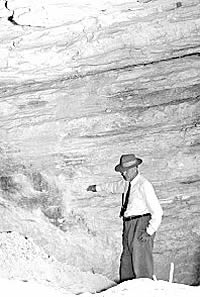
Geologist E. H. Sellards, director of the Texas Memorial Museum, shown at the mouth of the shelter. Photo by Glen Evans, 1948.

Click images to enlarge

What is the Pleistocene?

Known also as the "Great Ice Age," the Pleistocene is the geologic term for an epoch of the Quaternary period stretching from about 1.8 million to 12,000 years ago. The word "Pleistocene" derives from the Greek words "pleistos," meaning most, and "ceno," new. The first humans entered North America at the end of the Late Pleistocene when megafauna such as mammoth, cave lion, ground sloth, dire wolf, and giant bison still roamed the continent.

photo of crewmember
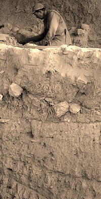
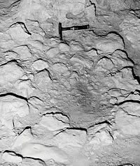
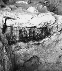
TMM crew member Powell Goodwin exposes the rock pavement at the base of Zone 4. Below him, layers of deposits which have been outlined with a sharp tool to make them more visible, can be seen in the trench wall, foreground. Photo by Glen Evans.
drawing of a camel
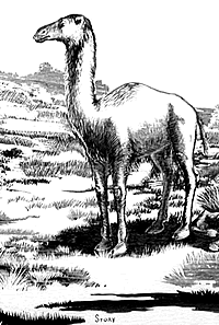
Camels roamed the Edwards Plateau during Late Pleistocene times. Remains of the extinct species Camelops were found in Zone 3. The animal may have been dinner for a large carnivore, such as lion or dire wolf, denning in the shelter. Drawing by Hal Story.
photo of Melissa Winans
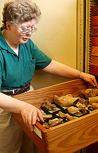
University of Texas vertebrate paleontologist Melissa Winans looks over a drawer of the Kincaid faunal materials that she analyzed in the late 1970s. The drawer she is holding is filled with the remains of large fauna, including bison and camel. Photo by Susan Dial.
drawing of a mammoth
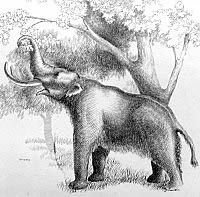
A mammoth browses tree leaves in this drawing by Hal Story. Fragments of bone, teeth, and tusk were found in Zone 3, and one partial elephant rib was found crushed between large boulders of the man-made rock pavement on the upper surface of the clay. It is not known whether the predators were human or carnivorous animals. Drawing by Hal Story.
painting of an American lion
An American lion, as interpreted by artist George Teichmann. The Late Pleistocene creatures were larger than the modern African lion, standing almost 5 feet tall at the shoulder. They were prevalent throughout Asia and North America before their extinction. Detail of painting by George Teichman, courtesy of the artist and the Yukon Beringia Centre. Click to see full image of Ice Age creatures in the Yukon.
floor of zone 3
Section of the rock pavement capping Zone 3. Paleoindian people constructed this pavement over the muddy shelter floor to provide a dry living surface. During Late Pleistocene times, a spring seeped from the rear wall, forming a shallow pond in the center of the shelter. Photo by Glen Evans.
graphic of shelter interior
Stratigraphy of shelter interior, showing location of extinct bison bones in travertine deposits at base of Zone 5 and nearby artifacts possibly associated with the bone. Graphic by Glen Evans.
photo of stones
Sample of the stones used to pave the shelter. Most were rounded cobbles and small boulders of Edwards limestone, likely originating in a formation upstream of the shelter, and ranged in length from 4 to 32 inches and weighed up to 70 pounds . Photo by Susan Dial. Click to enlarge.
photo of cave lion jaws
The ferocious canines and massive jaws of the cave lion, or American lion , are shown in this interpretive reconstruction of a skull (not from Kincaid). A canine was found in Zone 3 at Kincaid along with a variety of other animal bone, suggesting a lair where the giant creature fed upon his prey.
photo of rock pavement
An eroded section of the rock pavement near the front of the shelter. Portions of the pavement were partially destroyed by floodwaters washing into the shelter during Late Pleistocene times. Photo by Glen Evans.
photo of stone tools
An array of stone tools and tool-making debris was found on the stone pavement and just above in Zone 4. Archeologist Mike Collins has identified a number of these as distinctively Clovis, including the small, expended blade core at left and the broken fluted preform at lower right.
photo of mammoth bones
Limb bones of extinct bison (Bison antiquus), still jointed, or articulated, were preserved in travertine deposits at the back wall of the shelter in the upper Zone 4 deposit. This appears to be all that was left of a possible Folsom-era event. Much of the zone was eroded by flooding in Late Pleistocene times. Some 10,000 years later, treasure hunters dug a large pit into the deposits obliterating whatever remained at this level. Photo by Glen Evans.

A remarkable feature that occurred in the older part of the shelter fill was a man-made rock pavement that rested on the surface of Zone 3 clay and was overlain by travertine, clay, and limestone grit (Zone 4). The front area of this pavement was partially destroyed by stream erosion from high-level flooding of the ancient Sabinal River before deposition of Zone 4 sediments; and two sections of the pavement had been destroyed by the old treasure-hunter diggings made prior to the 1948 excavation.

Fortunately, substantial parts of the pavement were still intact, including one large segment covering more than 100 square feet (9.3 square meters) in the northeastern part of the shelter. In the front part of the shelter, where stream erosion cut out part of the underlying Zone 3 clay, the heaviest pavement stones were let down on the old erosion surface. Smaller pavement stones undoubtedly were washed away by the flood current. The shelter floor plan (below, left) shows the undisturbed area and the eroded area of the pavement as found in 1948. The stratigraphic position and form of the pavement is best shown in longitudinal and cross section profiles.

The pavement stones were well-rounded, partially rounded, and angular boulders most of which range from 8 to 14 inches (20 to 36 cm) in maximum diameter. These stones were Cretaceous (chiefly Edwards) limestone and flint, and are not from the Anacacho Formation in which the shelter resides. The smallest boulders still in place were 4 to 5 inches (10 to 13 cm) in diameter. The largest pavement stone was 32 inches (81 cm) in maximum diameter and weighed approximately 70 pounds (31.8 kilograms).

A large number of the stones were placed with flat or sharply angular sides down, and with the dome or rounded sides upward. The boulders were fitted closely together in a manner similar to that used in modern stone patios. Cracks between the larger boulders were filled with small, angular limestone fragments and some rounded stream pebbles. This chinking of the larger cracks in the pavement was done deliberately, as the manner and level of in filling was similar in all parts of the uneroded pavement.

Features on the surface of Zone 3 clay beneath the pavement show clearly that the stones were emplaced while the clay was still in the form of wet mud. The larger stones sank into the mud, forming prominent depressions, and peaks. The mud squeezed upward, in some cases several inches, into the spaces between the boulders. Bones of alligator, elephant, and horse, which also were found in both overlying and underlying deposits, were found wedged and crushed between some of the pavement stones.

Some of the stones used in the pavement show the characteristic rounding produced by stream-bed erosion. Some of the larger limestone boulders exhibit weathering features characteristic of boulders that have lain for a long time partially buried in soil. Most of the pavement stones are derived from formations which do not crop out in the vicinity but are known to crop out upstream along the Sabinal River. Similar stream-transported boulders occur commonly in the riverbed near the shelter at the present time.

The constructional arrangement of the pavement stones, and the fact that most of them could not have originated within the shelter and could not have been transported and deposited by any natural agency, precludes any viable explanation other than that the pavement was made by deliberate human effort. The preserved portion of the pavement covers only that part of the shelter floor containing the underlying pond clay deposits of Zone 3. It seems evident that the purpose of the pavement was to cover the muddy portion of the shelter floor in order to make it more habitable.

The previously mentioned patches of somewhat older, intra-zonal cobblestone pavement differ from the rock floor pavement in several ways: the individual stones are considerably smaller, more loosely fitted together and have little or no chinking in the spaces between the cobbles. Flood waters washed through the shelter at different times, and this kind of erosion could account for the loosely fitted nature of the cobbles—but not for the transport or arrangement of the small pavement patches. These pavement sections appeared to be in substantially their original location; however, there is no indication that they are segments of the larger pavement that were isolated by stream erosion.

The apparent purpose for making the pavement patches was to cover muddy spots on the shelter floor. There is no reason to believe that the cobblestone patches are very much older than the larger and more substantial rock floor pavement, as they are separated by sediment only a few inches thick. It seems entirely possible that the same people made both pavements.

Bones of extinct species of vertebrates found in sediments immediately below and above the pavement indicate that the pavement was made in Late Pleistocene times by Paleoindian people who quite possibly had hunted the animals for food and for other uses. Artifacts found at higher levels in Zone 4 are thought to belong to the occupants who made the pavement.

Clovis Toolmaking

Zone 4. This zone holds the major Pleistocene-age cultural deposit in Kincaid Shelter—a Clovis stone tool "workshop" and habitation area. Zone 4 rests directly on and covers most of the stone pavement. Geologically, the deposit consists of three facies, or stratigraphic features—travertine near the back wall of the shelter, ponded clay with particles of limestone grit in the central part of the shelter, and primarily grit in a sparse clayey matrix near the front of the shelter. The "grit" in the two forward facies is small angular to sub-angular pieces of limestone. Zone 4 deposits apparently resulted from ponding of seep spring water issuing from the back wall of the shelter and the action of moderately swift Sabinal River flood waters encroaching through the front of the shelter.

The upper surface of Zone 4 is an erosional disconformity which, in places, completely removed Zone 4 and exposed the stone pavement. This disconformity marks the break between the Pleistocene and Holocene deposits (Zones 5 and 6) in the shelter and, as such, is the most significant stratigraphic boundary in the shelter fill. It separated underlying deposits containing ancient cultural materials and bones of extinct animals from overlying deposits containing later cultural materials and bones of modern animals. The erosion was deepest in the front part, where it completely cut out Zone 3 and displaced the rock floor pavement.

The travertine—a hard, calcium carbonate deposit formed by seep springs—occurred as an irregular sheet, 8 to 12 inches (20 to 30 cm) thick, that extended down the back wall and 6 to 8 feet (1.8 to 2.4 m) outward into the shelter. The clay deposit averaged only 3 to 4 inches (8 to 10 cm), and the grit deposit had a maximum thickness of 24 inches (61 cm).

Animal bones and teeth, generally in a poor state of preservation, were present in Zone 4 and include extinct taxa of bison, horse, mammoth, and ground sloth. Other animal remains included alligator, turtle, badger, racoon, and antelope, all of which occur in or near the area today. The advanced state of decomposition indicates a very slow rate of deposition for Zone 4 sediments. The bones evidently were subjected to surface weathering for a long time before being completely buried by the deposits.

The best preserved fossils of Zone 4 were found embedded in the hard travertine in the back part of the shelter. A few bones of a large extinct bison (Bison antiquus) were found on the upper contact of Zone 4, and probably were exposed by the erosion that preceded deposition of Zone 5. The articulated condition of some of the fossils, including the bison and several alligator vertebrae, rules out the possibility that they could have been derived from older deposits.

The stone tools and tool-making debris found in Zone 4 bear distinctive Clovis attributes, according to archeologist Mike Collins who has analyzed this assemblage (see Kincaid Revisited section for more detail). Several flakes, four biface preforms broken during manufacture, the basal fragment of an obsidian projectile point, modified flakes, three cores, and a polyhedral blade core were found on the stone pavement and in Zone 4. A fluted preform was found on the contact between Zones 4 and 5 and refits with one of the biface preforms noted above. In addition, a small, reworked Clovis point found in the treasure-hunters' backdirt is attributable to Zone 4 on the basis of adhering travertine. Evans noted that the obsidian point was associated with the fossil bison bone.

On the basis of faunal evidence, Zone 4 can be assigned to the Wisconsin Stage of the Late Pleistocene, and the presence of Bison antiquus indicates a late substage rather than an earlier part of the Wisconsin. It is perhaps significant that the size of the bison bones from Zone 4 compares quite closely with those of larger individuals from the bone beds containing Folsom points at the Lubbock Lake Site of northwestern Texas and the Blackwater Site No. 1 of the Clovis-Portales area in eastern New Mexico.

Except for differences which can be accounted for by accidents of preservation, there seem to have been no important changes in the fauna from Zone 3 and Zone 4. Moreover, the sediments comprising Zone 4 were in some respects very similar to those of Zone 3. This indicates that depositional conditions within the shelter during Zone 3 time continued into the period represented by Zone 4.

Later Deposits

photo of pavement on top of clay
Close-up of pavement resting on underlying brown clay of Zone 3, against east bedrock wall. Markings on the surface of Zone 3 clearly indicated that the pavement was laid while the clay was wet and plastic. Photo by Glen Evans, December 1948. Click to enlarge.

The constructional arrangement of the pavement stones, and the fact that most of them could not have originated within the shelter nor been transported and deposited in this arrangement by any natural agency, precludes any satisfactory explanation other than that the pavement was made by deliberate human effort.
-Glen Evans, 1948

photo of alligator scute
This alligator scute, a section of the bony, armor-like plating in the skin of the reptile, was found in Zone 4. Photo by Susan Dial.
floor plan of shelter
Floor plan of the shelter showing eroded area of pavement and front margin. Map by Glen Evans. Click to enlarge.
photo of a section of stone pavement
Section of stone pavement capping Zone 3, showing overlying grit and tan silt zones. Photo by Glen Evans, TARL archives. Click to enlarge.
drawing of Bison antiquus
The massive Bison antiquus was nearly a foot taller and perhaps a full ton heavier than the modern bison. Bones of this animal were found in Zones 3 and 4. Drawing by Hal Story. Click to see size comparison.
photo of Clovis spear point
This small, reworked Clovis spear point was found in the treasure-hunters' backdirt pile, but investigators were able to attribute it to Zone 4 deposits based on the "tell-tale" travertine matrix adhering to the tip. Perhaps a Clovis hunter discarded the spent projectile point near the seep spring at the back of the shelter, where it became coated with the hard, calcium carbonate substance.
Expanded cross-section of shelter and terrace deposits
Expanded cross-section of shelter and terrace deposits. Note that the lower zones in the interior are truncated at the outer edge of the shelter. None of the interior deposits could be correlated to those of the terrace. Graphic by Glen Evans.
photo of dart points
Late Paleoindian and Early Archaic dart points were among the artifacts found in Zones 5 and 6. At top left and middle, are Angostura; top right, Bandy, representing Early Archaic cultures. At bottom, are two distinctive "swallow-tail"-shaped bases of Golondrina points, indicative of a Late Paleoindian occupation. Photo by Aaron Norment. Click to see more.
photo of artifacts
Artifacts diagnostic of the Late Prehistoric period (circa 400 to 1200 years ago) were found predominately in the upper levels of Zone 6. At top are sherds of bone-tempered pottery associated with the makers of Perdiz arrow points (middle row). Scallorn and Edwards points (bottom row) represent an earlier Late Prehistoric time period termed the Austin interval. Photo by Aaron Norment. Click to enlarge.
photo of Folsom point
One of the Folsom points recovered from disturbed fill.

Zone 5. Zone 5 within the shelter interior was a silty, midden-rich deposit containing remains of Holocene fauna and cultural materials diagnostic of the Archaic period. In places, Zone 5 was up to 42 inches (1.1 m) thick, and consisted mainly of fine-grained, calcareous silt. Small irregular masses of travertine occurred in the zone at and near the back wall of the shelter.

The lack of ponded clay and diminished presence of travertine indicates that the spring at the back of the shelter had ceased to flow prior to deposition of Zone 5; in fact, no travertine caps the surface of Zone 4, further indicating that the spring did not flow during the interim between the end of Zone 4 and beginning of Zone 5 accumulation.

Zone 5 is separated from the underlying older fill, both within and outside the shelter, by a distinct erosional surface, except in limited areas where it is in direct contact with the stone pavement. The contact with the overlying Zone 6 is well-defined only in a relatively small area near the back of the shelter. Elsewhere the division between Zones 5 and 6 is based partly on differences in compaction and color of the sediments, and partly on the basis of relative abundance of cultural materials. The fauna of both Zone 5 and Zone 6 are modern species.

A few non-diagnostic specimens with Zone 4 matrix adhering to them as well as a fragmentary Clovis preform that refits with a fragment found in place in Zone 4 were found in the lower few centimeters of Zone 5. This suggests that some blurring of the boundary between Zones 4 and 5 resulted from the erosion of the surface of Zone 4 and the nature of the initial deposition of Zone 5. The proveniences of diagnostic artifacts within Zone 5 do not record a clear stratigraphic ordering, but dart point types representative of the early, middle, and late Archaic periods are present. There, are also various adzes, scrapers, cores, bifaces, engraved stones, and other artifacts.

As shown in the longitudinal profiles, Zone 5 sediments extended outward and graded into river terrace deposits immediately in front of the shelter. Excavations showed that the river channel lay directly in front of the shelter during at least a part of Zone 5 time. Occupational refuse from the shelter spilled over the river bank and was incorporated into the stream deposits that eventually filled the channel. Mixing of materials undoubtedly took place in the steep talus slopes on the old river bank. Consequently, it is not possible to accurately equate given parts of the terrace section of Zone 5 with equivalent parts within the shelter.

Zone 6. This zone, the uppermost and youngest unit of shelter fill essentially was a midden (trash) deposit. It reached a maximum thickness of 30 inches (76 cm) within the shelter and consisted of loose, ashy, dust, charcoal, burned rock, bone, shell, pottery and various stone artifacts. These include Late Prehistoric artifacts as well as those dating to the Archaic. Some of the Archaic specimens are of Early Archaic affinity and indicate some mixing of deposits in the course of human utilization of the shelter. Also present are several Historic period artifacts of metal and glass from the last half of the 19th and early part of the 20th centuries. Of particular interest are an 1857 U.S. half-dime and a brass button from a Confederate uniform jacket.

Significantly, in Zone 6, the remains of modern bison (Bison bison) appear for the first time. There appears to have been a shift toward hunting larger animals—such as deer and antelope—and decreasing use of smaller animals, such as rabbits. According to Winans, this may indicate a change in what was available in the area.

In the terrace section in front of the shelter, Zone 6 thickened to 36 to 40 inches (91 to 102 cm) and apparently represents the last stage of filling of the old, abandoned channel of the Sabinal River. Since the end of aboriginal occupation in Zone 6 time there has been very little erosion or deposition on the terrace surface in the immediate vicinity of the shelter.

Disturbed Fill

The surface of the shelter fill was covered with backdirt from the treasure-hunters' pit as well as from a few smaller, shallow holes dug into the site prior to the 1948 excavations. A large collection of artifacts was obtained by screening this material and included two additional Folsom points, a number of other early projectile points such as Golondrina, Midland, and Angostura, many Archaic and Late Prehistoric types, a fragmentary steatite vessel, decorated stones, bones, and other cultural evidence.

large arrow to click on to follow Kincaid Shelter exhibit
photo of small point
A small reworked point identified as Midland is one of several later Paleoindian types from the shelter. It was found in disturbed contexts.
photo of dart points
Late Archaic occupations were represented by a variety of dart points, including (l-r) these Pedernales, Castroville and Montell. Photo by Aaron Norment.
photo of historic artifacts
More recent visitors at the shelter left behind glass and metal artifacts, including a Confederate uniform button and a 1857 U.S. half-dime. The uniform button is marked with an "I" for infantry, and possibly belonged to a soldier in Gen. H. H. Sibley's brigade who passed through Sabinal, Texas, en route to New Mexico, where they fought the battle of Val Verde near Fort Craig in 1862. Photo by Aaron Norment. Click to enlarge.