About 650 years ago, native peoples established a camp deep in the South Texas Plains overlooking a
small, slowly flowing stream. First
and foremost, the archeological evidence shows they were a hunting people who ranged out from the camp in search of preferred prey, hoofed animals: deer, antelope, and buffalo. But hunting big game animals was not what brought in most of the food—they also gathered, picked, dug up, snared, hunted, and grabbed all manner of smaller creatures, plant foods, and other natural resources.
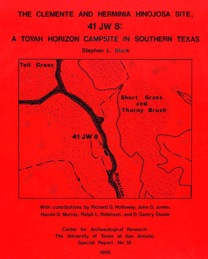
That the Hinojosa site
represents a substantial and repeated encampment of women, children, and men, is shown by the diverse range of tools, ornaments, cooking features, and animal bones they left behind. Many
of their artifacts are characteristic of the Toyah culture, which
spread across the Edwards Plateau of central Texas and deep into the South Texas
Plains in the 14th century. Yet they were not immigrants who brought new ideas and things from afar; they were peoples who followed centuries-old ways of life in the South Texas Plains.
Here the story of the Hinjosa site is told in both broad stroke and gritty detail,
arranged so you can learn as much or as little as you choose. The exhibit tells the story, but the supporting archeological evidence and particulars can be studied by reading sections of the technical site report (follow the  icons), and by looking at
the enlarged images (follow the
icons), and by looking at
the enlarged images (follow the  icons). The details conveyed by the descriptions, numbers, special studies, and interpretations presented in
the published archeological site report will be of interest mainly
to serious students of archeology. Dig as deep as you like.
icons). The details conveyed by the descriptions, numbers, special studies, and interpretations presented in
the published archeological site report will be of interest mainly
to serious students of archeology. Dig as deep as you like.
Toyah Cultural Horizon
We don't know what the people who camped at the Hinojosa site called
themselves or in what tongue they spoke. Their descendants would have been among
the many linguistically diverse native groups that came to be
lumped together as Coahuiltecans, a somewhat troublesome word. Properly it is a geographical term,
rather than an ethnic classification or tribal name. (See Who Were the "Coahuiltecans"?)
Although their ancestry was
likely local, the Indians who camped along the creek had adopted key
elements of Toyah culture, a phenomenon that spread across the cultural horizon of central
and southern Texas during the latter part of the Late Prehistoric period,
about 600-700 years ago during the 14th century (A.D. 1300-1400). Archeologists have also referred to the Toyah "culture" as a phase, interval, or horizon.
Archeologists have long thought that Toyah culture represents a rapid and
widespread adaptive shift from a broadly based hunting and gathering economy to one based mainly on bison (buffalo) hunting. The impetus for this shift was said to have been triggered by the
return of herds to the region around A.D. 1300, after hundreds of years
of virtual absence. Some have suggested that Toyah culture was introduced
and perhaps spread by immigrant peoples who followed the bison herds into the region from the Southern Great Plains far to the northwest. The Hinojosa site tells quite a different story.
The evidence reveals a campsite frequented by local peoples who
hunted deer and antelope much more often than bison. These big game animals were supplemented by many smaller critters and an archeologically invisible wealth of plant foods. It does not look at all like they were
newcomers to the region or visiting hunters following bison herds. All of their surviving artifacts were made from materials that came
from the local area, no more than 50 miles away. They
followed essentially the same way of life that generations upon generations
of peoples had in the South Texas Plains. Yet, they had indeed adopted the
trappings shared by dozens and perhaps hundreds of small societies over roughly 25% of the total area of Texas (67,180 square miles or 174,000 square kilometers).
In the concluding section—Hinojosa Revisited—the Toyah
culture idea is reassessed based on what was learned from the site. But here
is the bottom line: Toyah culture is a shared set of characteristic artifacts
and technologies perhaps better thought of as a "cultural horizon."
It is obvious that this pattern was shared by diverse groups with different names,
histories, languages, and much more. Explaining the rapid and widespread
spread of the Toyah cultural horizon is an ongoing research challenge.
The earlier simplistic idea that Toyah culture reflects a broad adaptive
shift to and emphasis on bison hunting is just that: overly simplistic.
Most groups seem to have continued to follow traditional patterns of hunting,
gathering, and consuming a broad range of plants and animals, adding bison
whenever they could, but that probably wasn’t very often for most. The
complex interactions among the many groups that were part of the Toyah phenomenon
is the worthy subject of continued research. Now back to the campsite in deep
South Texas.
Environmental Setting
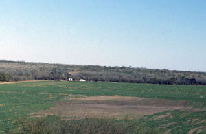
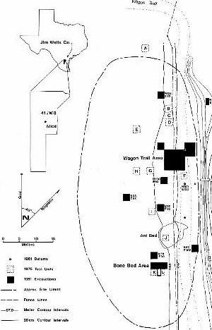
The Hinojosa site overlooks Chiltipin Creek, a tributary of San Fernando
Creek which empties into Baffin Bay within the famed King Ranch. In the
broader perspective, the site lies near the southern tip of the Great Plains,
that vast stretch of prairie grasslands that stretch for 1500 miles north to
south through the central part of North America. This part of the South Texas
Plains, however, is a savanna with grassy areas mixed with mesquite and
scrubby thorny brush. The grassy prairies of the flat Gulf Coastal Plain
lie less than 15 miles east of the Hinojosa site.
Today the site is surrounded by cultivated agricultural
fields, remnant strips of narrow wooded bottomland, and brush-covered pasture. The
historic impacts of livestock grazing, farming, irrigation, fencing, paving, housing,
and many other modern developments have transformed the area so much that it
wouldn’t be recognizable to the native peoples who once lived here.
Reconstructing the ancient setting of an archeological site is an integral
part of modern archeological research. Scientists with specialties in animal
bones (zooarcheology) and paleobotany were among those who helped analyze
and interpret the evidence from the Hinojosa site.
When the Hinojosa site was an active campsite some 650 years ago, the
climate was somewhat more favorable (wetter), the vegetation more varied
with more grass and less brush and trees, and there were more wild animals
including some which are no longer native to the region (such as antelope,
bison, and certain small mammals that are today present only in the wetter
Eastern Woodlands). The site was occupied near the onset of the Little Ice Age, a worldwide climatic shift to cooler and wetter conditions. Although the impact of changes in global climatic patterns is never uniform, most of the region probably did experience wetter than average conditions for several centuries.
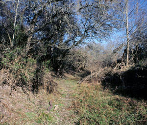
Chiltipin Creek was a small, shallow, spring-fed, mud-bottomed stream
that flowed constantly. This reconstruction is based on solid
evidence including the presence of several species of freshwater clams
(mussels) and numerous aquatic animals including water snakes, turtles, fish,
and muskrat. Today the creek flows only during floods and extended rainy
periods. The Amargosa Springs upstream from the site ceased to reliably
flow in the early 20th century as a result of overgrazing, vegetation
transformation (less grass, more brush and trees), and ever growing demands
on water resources.
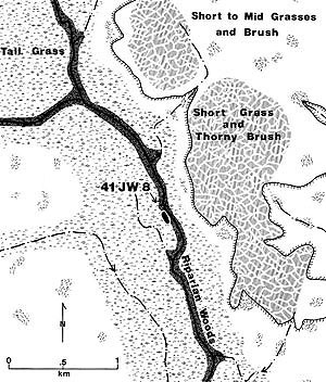
The drawing on the right shows the inferred environmental setting of the
Hinojosa site, about 1350 A.D. Three major habitats surrounded the site:
(1) a tall grass savanna on the deeper soils within the stream valley
(today’s prime agricultural land); (2) a narrow band of riparian
(streamside) woodland along the creek; and (3) an upland area dominated
by short grass and thorn brush on relatively thin soils. The local
topographic relief is quite subtle and varies no more than
about 60 feet within a half-mile radius of the site. Even so, the distinct
habitats supported different mixes of animals and plants, variation that
can be clearly seen in the animal bones.
To learn more about the site setting, study the accompanying
photographs and drawings and read Chapter 4 of the site report,
Environmental Setting.