Paleoclimate
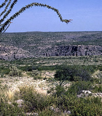
The modern climate of the Lower Pecos Canyonlands is semiarid and subtropical with dry, mild winters and hot summers. Rainfall averages 18 inches per year in Del Rio, the nearest major weather station. Hinds Cave lies some 50 miles northwest of Del Rio and here the average rainfall is closer to 14 inches per year. Most of the rain falls in the warmer months from April to October. Fourteen inches of rain is not much and the average amount masks considerable year-to-year variation and the fact that most rain falls during brief but intense thunderstorms. Droughts occur frequently and may last for several years. The livelihoods of Val Verde County ranchers have always been tied closely to the weather—periods of prolonged drought are economic low points that not all local ranchers survive. The same was doubtlessly true for prehistoric peoples living off the land.
Over the last 25,000 years, the climatic conditions affecting Hind Cave have not remained constant. The general long-term pattern has been a prolonged shift from cooler and wetter to warmer and drier conditions like those that prevail today. But this shift has been interrupted and sometimes even briefly reversed by shorter term climatic shifts lasting a few hundred or a few thousand years. Humans, however, would have been much more aware of and impacted by even shorter, comparatively brief climatic events such as drought cycles lasting a only few decades or a few years. Even a few unusually wet months would have created locally favorable conditions for plants, animals, and people. These brief climatic events are mostly invisible in the archeological and climatic record of the prehistoric past. Instead, we can usually discern only relatively long term major shifts.
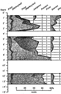
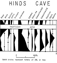
Here we will try to present a fairly realistic picture of what prevailing climatic conditions would have been like for those who visited Hinds Cave. To do this we have to consider lines of evidence from different materials and different localities and read a lot between the lines. To reconstruct the paleoenvironment, researchers track through time the presence—or absence—of certain plants and animals that are highly sensitive to climatic change. Samples of pollen, preserved plant parts, and certain animal bones help tell this story. Stream- and river-bank deposits may testify to alternating periods of intense flooding and slow flow.
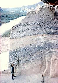
The evidence at Hinds Cave only covers a 9,500 year period beginning around 8,500 B.C. The cave does not preserve an unbroken, ideal climatic record. Instead it is a complex archeological site into which people selectively hauled all sorts of things, such as plants laden with pollen, which may have left misleading climatic signals Those items then became mixed with other things as occupants tromped about, dug holes, and so on. Adding to the problem is the reality that they routinely used plant remains as fuel and as packing materials for earth-oven baking, a process that added literally tons of burned rocks and lots of ash and charcoal into the deposits. In other words, it is impossible to accurately reconstruct climate conditions based solely on the tampered evidence from Hinds Cave.
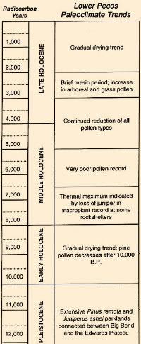
We know from fossil pollen records of other localities in the region that around 25,000 years ago the Hinds Cave region would have been much cooler and wetter than it is today. Based on this evidence, we infer that the average temperature variations between summers and winters would not have been as great as they are today. Winters would have been long and cold, snowfalls would have covered the ground during much of the winter, and water dripping into cracks in the limestone walls of rockshelters would have expanded as it froze. That process, called ice wedging, would have been repeated over and over again each winter causing thin sheets of limestone to flake off the ceilings and side walls of rockshelters forming thick layers of broken rocks and rubble (called spalls) on the shelter’s surface. Later, during the warmer summers, rain water, containing weak amounts of carbonic acid, would seep into shelters and dissolve the fallen spalls to piles of tiny, dust-size particles. The deepest and earliest deposits at Hinds Cave are composed mostly of cave dust and limestone spalls, but we do not know precisely when they formed—just sometime before 11,000 years ago.
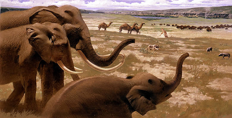
During the Wisconsin Full Glacial Period (around 25,000 years ago) winters would have been long and cold with frequent overcast skies and a constant north wind that would chill the region. Summers would have been warm and moist with cold nights, much like today’s summers in regions of central Colorado. The canyon below Hinds Cave probably supported stands of junipers, pinyon and ponderosa pines, and even a few spruce trees. The uplands “above” and surrounding Hinds Cave would have been covered by patchy areas of grasses mixed with waist-high bushes of sagebrush (Artemisia). That type of mixed grass-sagebrush vegetation would have provided an ideal habitat for grass and shrub grazing animals including the mammoth, mastodon, camel, horse, and large bison. These Ice Age animals all died out between 18,000 to 11,000 years ago, mainly as a consequence of a warming climate.
As the climates in North America began to warm, the continental glacier began to retreat toward its present location near the North Pole. With that glacial retreat came changes in wind patterns and temperatures. We suspect that much of that change was caused by a gradual northward shift in the path of the upper atmosphere’s jet stream. During this period of change, called the Late Glacial, climate ameliorated and precipitation increased from the cooler, drier Full Glacial period. Winter snows still fell at Hinds Cave and pools of water in the canyon floor below the shelter still froze solid, as did the margins of the nearby Pecos River. Winter days were not quite as cold nor did the winters last as long. Summers were cooler and wetter. Overall, the Late Glacial climate was milder and perhaps more inviting for humans.
During the millennia just prior to the dawning of the Holocene (modern geological era) around 11,000 years ago, the climate became noticeably warmer and drier. The cold-loving plants growing near Hinds Cave lost their dominance and finally disappeared. The ponderosa and pinyon pines disappeared from the canyon slopes as their new seedlings encountered summers too hot and dry for them to survive. Soon there were no more pines growing near Hinds Cave. The last cooler-wetter plants to disappear were probably the juniper bushes and trees that may have survived into the early part of the Holocene in protected areas of the canyon below Hinds Cave. But, sometime before 8,000-9,000 years ago they too disappeared locally as the summers continued to get hotter and drier.
Meanwhile, in the uplands above Hinds Cave, the cold-loving sagebrush bushes and hardy winter grasses could no longer tolerate the drier and hotter summers and began to thin around 15,000 years ago and were almost gone by 11,000 years ago. Like the pines and spruce, they too disappeared leaving behind new areas covered with temperate-climate grasses and new types of small, shrubby bushes and trees such as scrub oaks, mountain laurel, and sumac.
At some point during the Late Glacial period between 18,000-11,000 years ago, the first groups of Native Americans entered the Lower Pecos region and began making the area near Hinds Cave their new home. Evidence that they were here is seen in the deposits from a number of nearby sites, especially Bonfire Shelter located only a few miles southwest of Hinds Cave (see Bonfire exhibit). There, skilled early Native Americans hunted some of the last large Ice-Age game animals in North America before those animals became extinct. Bonfire Shelter contains unmistakable traces of broken artifacts and the bones of large animals that they smashed while butchering their game. Perhaps these same groups visited Hinds Cave as well. If they did, the record of their early visit is still buried beneath tons of dirt in those areas of Hinds Cave that have not been fully examined.
With the relatively rapid change in climate from cool to hot and from wet to dry around 11,000 years ago, the local vegetation became highly stressed. The cold-loving plant species, which could no longer survive, disappeared. It was during this transition period that sudden, and often heavy, rains created flash floods that swept away much of the unguarded topsoil from upland sites and turned the canyons into torrents of water that ripped away the talus soils and vegetation growing on the slopes of the Hinds Cave canyon.
Within one thousand years after the onset of the Holocene (11,000 years ago) much had changed in the Hinds Cave region. At some point before the beginning of Holocene all of the abundant big game animals in the region disappeared. Gone were the mammoths, mastodons, horses, giant Pleistocene bison, camels, and even the sabertooth cats that once preyed on those large animals. Gone also were the spruce, pines, junipers, and sagebrush. In the place of these lost plants and animals came a host of new invaders. Desert-loving plant species such as agave, yucca, sotol, cactus, buckthorns, acacias, and mesquite expanded from more sheltered canyon areas and came to dominate the area’s vegetation. Smaller game animals including deer, modern bison, rabbits, wolves, and cougars filled the ecological niches previously used by large Pleistocene animals.
On the talus slopes and in the canyon below Hinds Cave deposits of windblown sand and dirt accumulated and encouraged new species of plants to take root. Bushes and trees including cottonwoods, oaks, sumac, willows, hackberry, persimmon, and mountain laurel filled the canyon floor and talus slopes. Mustang grape and poison ivy vines wound their way upward through the branches of oak trees and, on the ground, buffalo gourds, grasses, sedges, and various types of berry bushes competed for the rich soils. Some of the larger and deeper potholes in the canyon floor below Hinds Cave held water throughout the year and provided essential water for game animals while it also supported a variety of small fish, amphibians, and reptiles.
Between 11,000 years ago until around 8,000 years ago the area around Hinds Cave may have seemed a bit like a Garden of Eden to those who lived there. The climate was much warmer than it had been before 11,000 years ago. Although the winter winds were still cold, it rarely snowed and the skies were mostly clear and sunny during the day. The nearby Pecos River provided both a permanent water source and a place to swim and cool off during the hottest summer afternoons. By 9,000 years ago, the plants that people brought into Hinds Cave are the same ones growing near the shelter today, signaling the establishment of the modern environment.
Around 8,000 years ago some significant climatic changes occurred in the Hinds Cave region. Hotter and drier conditions heralded the establishment of a more or less modern climate regime with relatively dry, cool winters and hot summers. Amid the generally drier conditions, there were occasional violent, transformative events caused by stalled tropical storms. During these infrequent events, massive thunderstorms unleashed torrents of water that swept rapidly across the unprotected uplands capped with impervious limestone and down into canyons and river valleys causing flash flooding and widespread erosion. Some scientists believe that a shift in upper wind patterns around 8,000 years ago carried moisture-laden clouds that formed over the Pacific Coast and Gulf of Mexico much further inland where they created extensive and heavy downpours of such intensity that they resulted in repeated cycles of flooding and erosion. We remain uncertain about what actually triggered the changes, but the results seen in the profiles of riverbank deposits today, must have been dramatic.
Some scientists call this time period the Altithermal, which they believe lasted around 3,000 years. Current speculations tag the Altithermal as a period of extreme dryness and very hot summers and mild winters and is believed to have affected much of west Texas and most of the American Southwest. The climatic changes during this 3,000 year interval are written in the deposits of archeological sites along the Pecos River, such as Arenosa Shelter, and along the Rio Grande and Devils Rivers, at sites such as the Devil’s Mouth Site. At both Arenosa and Devil's Mouth, the deposits record repeated intervals of terrible floods that stripped the sites of older soils and replaced them with new deposits of sand and clay as the rivers receded. It seems likely that the canyon below Hinds Cave may have flooded repeatedly during this 3,000 year period, but the cave's deposits show that flood waters were never high enough to reach the rockshelter.
The climate during the last 4,000 years at Hinds Cave was probably very similar to conditions in that area today, except for one brief period around 2,800 years ago. Pollen records and plant remains recovered from Hinds Cave deposits during this 4,000 year period show little variation suggesting that aside from slight variations in rainfall or temperatures from year to year, the climate and local vegetation probably remained fairly stable. Winter freezes became less common, summers remained warm to hot, and annual rainfall was quite variable with periodic droughts lasting many months or even years.
One climatic event, around 2,800 years ago (800 B.C.), is not evident in the deposits of Hinds Cave, but it is recorded in the fossil pollen records of deposits at other sites both east and west of Hinds Cave. At Bonfire Shelter, less than 10 miles away to the southwest, a thick layer of bison bones dates to about 800 B.C. The layer shows that skilled hunters succeeded in stampeding hundreds of bison over the cliff above the shelter during one or several closely spaced events (see Bonfire exhibit). We infer that bison migrated southward into the region in search of winter grasses, perhaps in response to extremely cold winters in their normal haunts, the central and southern Plains hundreds of miles to the north of Hinds Cave. The pollen record from the Devil’s Mouth site about 40 miles southeast of Hinds Cave also reflects a brief cool and wet interval at about the same time (roughly 2500-3000 years ago). While the brief shift to cooler and wetter conditions must have also affected those people using Hinds Cave, no evidence of this has yet been found.
By 2,500 years ago, the gradual warming and drying trend returned to form climatic conditions similar to those of today with dry and mild winters and hot summers. Droughts were frequent and sometimes prolonged, lasting years and even decades or longer. Evidence from elsewhere in North America and in the Northern Hemisphere suggests there have been minor but significant global climatic shifts that would have impacted the region. For instance, the so-called “Little Ice Age” between A.D. 1350-1850 saw colder winters and increased moisture in many areas. Perhaps future studies will determine if such events played a role in the climatic history of the Lower Pecos Canyonlands.