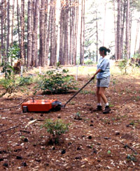
Crew member Dana Anthony scans the
site surface with a radar trolley in a pine forest clearing.
Remote sensing such as this procedure helped to locate
a variety of Civil War-era features. Photo by Steve
Black.
Click images to enlarge
|
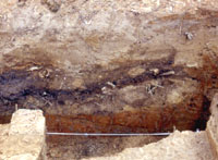
Remains of Civil War-era latrines,
including this pit shown in the wall profile, were found
during excavations. Photo by Steve Black.
|
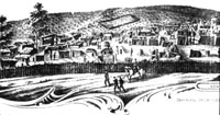
Contemporary pictorial records guided
the excavators in their exploration; this south view
of Camp Ford depicts the approximate area targeted in
A&M investigations.
|
|
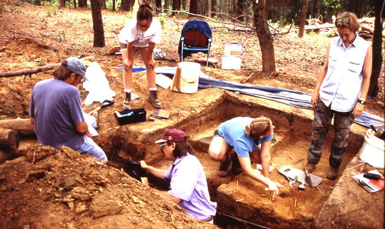
During the summer of 1997, archeologists from
the Center for Ecological Archaeology (CEA) at Texas A&M
University conducted exploratory investigations at Camp Ford.
Given the long history of impacts to the site—farming
and mechanical plowing, reforestation, highway construction,
the development of a swimming pool, and the ravages of relic
hunters—efforts were remarkably successful. Backhoe excavations
and ground penetrating radar revealed well-preserved trenches,
pits, and house floors representing the remains of stockade
wall trenches, refuse pits, and various types of residential
structures.
Fieldwork began with a surface survey that identified
the locations of both the original stockade walls and the
later expansion. Exploratory excavations revealed more than
70 archeological features, including 22 exposures of wall
trenches and six drainage ditches along all four sides of
the original stockade and along the south and east walls of
the expanded stockade. In addition, 19 house floors, 13 small
refuse pits, and five latrines were recorded.
Within the stockade area are the well-preserved
remains of hundreds of structures similar to those depicted
or inferred from Civil War era pictorial records of Camp Ford.
Structures include flat-floored cabins, dugouts more than
4 feet below the surface on hillsides, and pithouses with
basin-shaped floors. We found several hints of the historically
reported reservoirs along the spring-fed creek that were used
to obtain drinking water, to bathe, and to wash clothes.
Several posthole molds were encountered adjacent
to the stockade walls, and these may represent the locations
of guard stations along the wall. We also have the remains
of what may be a pithouse just outside the stockade wall near
the southwest corner where the guards' quarters were located.
Surface survey work and limited screening of
backhoe trench backdirt resulted in the recovery of numerous
artifacts. These include bone and wooden items made by the
prisoners, fragments of metal cooking vessels, glassware,
and pieces of ceramics among them, a terracotta-like ware
made by the POWs.
The artifacts and faunal remains, together with
the identified features, present a poignant reminder of Camp
Ford's POWs and guards, as well as slaves and citizens. Collectively,
they illustrate the interconnectedness of these diverse cultural
groups and their distinctive roles during the Civil War.
Much of the work in bringing the Camp Ford project
to fruition has come from local volunteers, particulary through
the more than 50-year effort of the Smith County Historical
Society. An interpretive center planned for the site of Camp
Ford will utilize what was learned through archeological investigations.
The actual layout of the camp at different time periods, as
revealed in archival maps and records and supported by excavations,
will be one aspect of this interpretation. Artifacts recovered
in excavations also will be on display at the center.
|
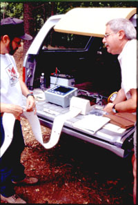
Data from ground-penetrating radar
surveys were printed out onsite and examined for clues
to underground features. Photo by Steve Black.
|
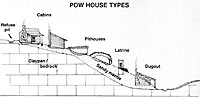
Schematic illustration of archeologically
identified POW house types shown in relation to the
thickness of underlying sandy sediments and terrain.
|
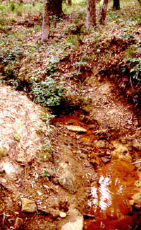
Traces of reservoirs likely built
by the prisoners were found during survey along this
small creek. Photo by Steve Black.
|
|