Texas Beyond History
The Varga Site: What We Can Learn from Technical Analyses of Archeological Remains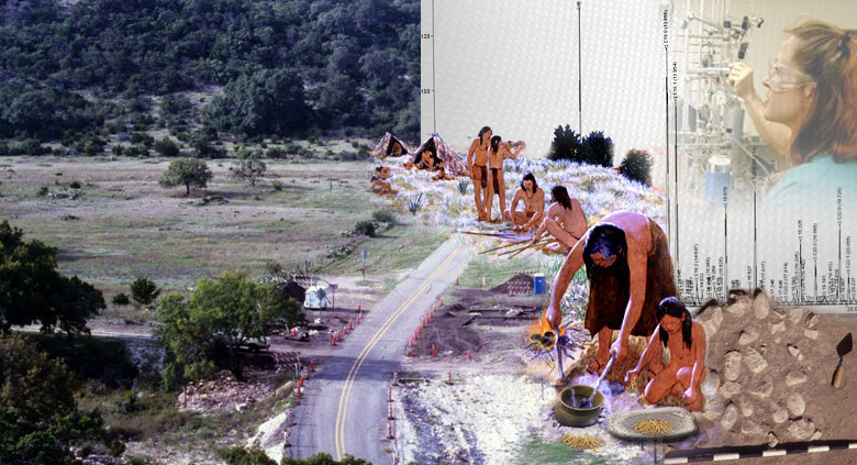
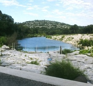
Native hunters and gatherers periodically camped at the Varga site over a nearly 6,000-year period, from about 6200 to 300 years before present (B.P.). Archeological excavations and a suite of technical analyses have provided glimpses of the various activities that took place at the site. Image credits: Native people shown in traditional activities from painting by Nola Davis, courtesy of Texas Parks and Wildlife Department; photos courtesy of TRC Environmental. |
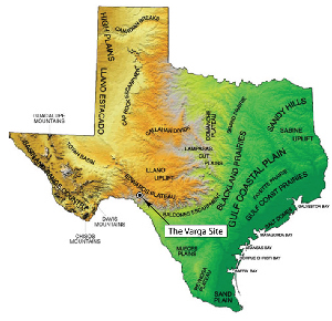
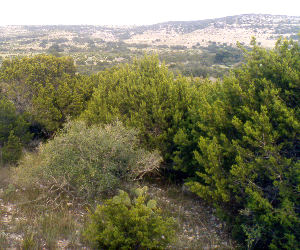
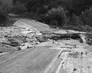
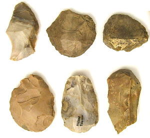
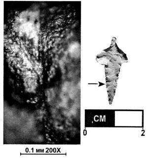
For more than 13,000 years, groups of mobile hunter-gatherers roamed across the Edwards Plateau looking for food and shelter. Although the rocky landscape appears inhospitable, with harsh environmental conditions and only limited resources, many native peoples in the past called this place home. Over the millennia, different groups of people set up their camps near the clear springs or water holes carved in the limestone bedrock or along the shaded stream banks. They would gather wood for their fires, kill local game such as deer and rabbits, harvest a variety of plant foods, collect rocks for use in cooking their food, and ultimately thrive within this environment. This is what happened here at the Varga site on at least four occasions and perhaps many more times before Europeans arrived in the area. Named after the local land owner, the Varga site (41ED28) is located in northeastern Edwards County just below the top of the Edwards Plateau and along Hackberry Creek. This small stream flows into the Nueces River in southwestern Texas near the western edge of the Balcones Canyonlands, a physiographic and ecological subdivision of the Edwards Plateau. The region is characterized by deep, rugged, parallel canyons that were carved through the limestone formations by southward-flowing streams. Below the Balcones Escarpment, the fault zone at the southern edge of the plateau, these streams flow across the nearly level Rio Grande plains of the Gulf coastal area and eventually discharge into the Gulf of Mexico. Today, as in the past, the stream valleys and rocky hills support a variety of animals and plants. Modern vegetation is a Juniper-oak savannah with a dense to open canopy of broadleaf deciduous and needleleaf conifer shrubs and low trees. These include Mountain Juniper (Juniperus sp.), a species which dominates the landscape today, Live Oak (Quercus virginiana), and Little Bluestem (Andropogon scoparius) grass. Wooded stream valleys contain several species of oak (Quercus sp.), elm (Ulmus sp.), pine (Pinus sp.), hackberry (Celtis sp.), pecan (Carya illinoiensis), walnut (Juglans microcarpa), and the stream floodplains support a variety of berry-bearing shrubs. Many of these plants and trees were present throughout the period of occupations at the Varga site and were used by the campers for food and fuel. Site DiscoveryThe Varga site was discovered during a cultural resources survey of the upper Nueces River Natural Area near the Devil’s Sinkhole. Searching for evidence of prehistoric or historic sites, the surveyors noted burned rock and chipped-stone artifacts scattered over an area extending roughly 250 meters (about 800 feet) along Hackberry Creek. Two dense accumulations of burned limestone, or “burned rock middens,” as well as several “fire hearths” also were found. Several years after the archeological survey, nature—in the form of another flood—conspired to bring investigators back to the site for more extensive investigations of the cultural remains. In both 2001 and 2003, heavy rains caused major flooding of area streams and rivers and destroyed the paved road that crosses Hackberry Creek. The Texas Department of Transportation (TxDOT) made plans to fix the road and solve the recurrent flooding problem for local ranchers. But before roadwork began, TxDOT archeologists inspected the location and identified a prehistoric site on the north side of the low water crossing. To comply with state and federal laws, TxDOT then contracted with TRC Environmental (TRC) of Austin to conduct archeological investigations at this prehistoric site. Following fieldwork and analysis of the findings, TRC prepared a two-volume technical report that provides a detailed scientific appraisal of the archeological site. The web exhibit you are reading is a public education outreach effort sponsored by TxDOT to summarize and illustrate the findings. Using Technical ToolsResearchers working on the materials recovered from the Varga site employed a variety of technical analyses to help understand more about the people who camped along Hackberry Creek in the past. The use of such studies has expanded considerably over the last few decades. Advances in technology, equipment, and collection techniques, as well as an ever-increasing database of findings from other sites, allows us to bring a much larger set of tools to bear on the materials recovered from the site. In addition to findings from conventional analytical approaches, much more detailed information often can be obtained by conducting several different technical analyses on selected objects and even soil samples. For example, a tool classified as an end scraper (based on shape and chipping along its edges) typically has been assumed to be used to scrape animal hides. But examination with the eye alone cannot reveal what materials it scraped or if it was used for other purposes. To extract more artifact-specific information, an archeologist might submit the tool for high-powered microscopic examination, or use-wear analyses, as well as other types of analyses. By these means we might find that the tool was coated with a glossy silica polish typical of processing plants. Or there might be bits of hair or feathers embedded along the tool edge, indicating contact with an animal. Because of advances in radiocarbon dating, some of these miniscule residues might also be dated. Using these types of analyses, our knowledge about this single tool expands considerably from the simple term, “scraper.” In This ExhibitUnlike most other exhibits on Texas Beyond History, the Varga site presentation focuses more heavily on these analytical techniques—the hows and whys behind the interdisciplinary sciences used in modern archeology. The Field Investigations and Findings section provides a brief overview of the field work and evidence recovered and incorporates the various findings into a cultural chronology for the site. How Do We Know That? provides a closer look at eight of the technical analyses employed and the specific findings used to help interpret the site. For archeology students and general audiences alike, this section provides a more-detailed view of the methodologies involved and the types of information which can be extracted from various types of remains. Old Assumptions and New Insights considers what has been learned and suggests avenues for the future. Credits and Sources provides background on the authors and additional sources to consult for more information.
|
|