The Caddo Homeland Base Map The Caddo Homeland Vegetation Map The Caddo Homeland Environmental Resources Map The Caddo Homeland Archaeological Sites Map Ouachita Mountains Eastern Caddo Homeland Kiamichi River Western Caddo Homeland Great Bend of Red River The Great Raft Caddo Lake Southwestern Caddo Homeland Sulphur River and Cypress Creek Drainages Arkansas Valley Ozark Highlands Grand River and Prairie Plains Edge Photo of Auburn Creek Photo of Bois D'arc Creek Photo of Kiamichi River Photo of a Partially Cleared Cypress Swamp Photo of a Pine Forest in Dallas County Photo of a Novaculite Quarry Photo of a Caddo River Valley in Fall Foliage Photo of Tupelo Bottomlands along Wolf Creek Photo of Grand Ecore Photo of Barry Brake Photo of Smithport Lake Photo of Oxbow Lake Photo of Sulphur River Photo of Wide Bend of Red River Photo of Oak Savanna of Illinois Valley Photo of Salem Plateau and War Eagle Creek Photo of Boston Mountains with Frog Bayou in the Distance Photo of Lower Lee Creek Photo of Cherokee Prairie
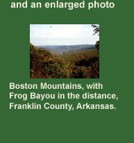
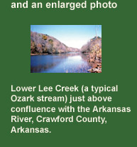
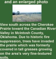
Click on a Tab to explore the Caddo Homeland

Tejas Main Tejas Main