“Uvalde” Gravels East
East of the Nueces ancient upland gravels occur in many areas, both in upland exposures and also in stream and river beds clearly derived from “Uvalde gravel” exposures. See "Uvalde" Gravels West for discussion of the geological uncertainty surrounding “Uvalde” gravels. Here we use the term to refer to ancient gravel deposits, and redeposited ancient gravels, found east of the Nueces River.
In comparison to similar gravels found west of the Nueces, the “Uvalde” gravels found in the eastern part of the South Texas Plains often occur in more massive deposits. There, somewhat larger cobbles and fine-grained materials are more common, particularly within the Guadalupe drainage basin. Perhaps this is because the Guadalupe drains directly from the heart of the Edwards Plateau, where good quality chert abounds. The gravel bars of the Guadalupe River itself likely include both relatively recent (Late Pleistocene and Holocene) gravels washed down from the Edwards Plateau as well as ancient gravels. See Guadalupe River Gravels. But the gravels in the many smaller streams that do not drain directly from the Edwards Plateau are from the ancient gravel deposits often lumped under the rubric “Uvalde” gravels.
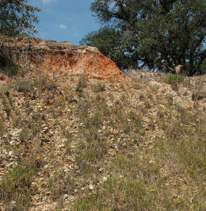
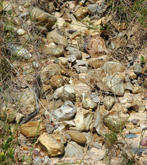
To take a specific example, “Uvalde” gravel exposures occur along Twelvemile Creek, near the Victoria/DeWitt County line. Twelvemile Creek is a tributary of Coleto Creek, itself a tributary of the Guadalupe River. The Twelvemile exposure illustrated here is within a geologically mapped exposure of the Willis Formation, which consists of Pliocene fluvial sands and gravels. The chert gravels in the accompanying photos are clearly alluvial in origin, and were gravel bars or channel deposits of a very high energy river in ancient times. Today, these ancient gravels also are commonly found redeposited in active gravel bars (and buried Holocene gravel deposits) along the Guadalupe and other rivers.
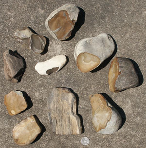
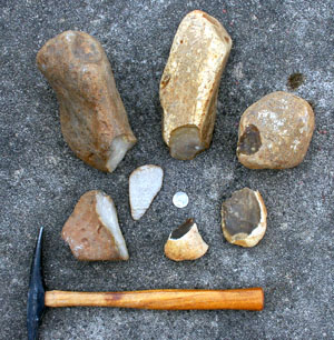
The Twelvemile cobbles range from 5-20 cm in length, but average around 10 cm (4 inches). Though the pieces are fairly small, flaking quality is good,. They are quite variable in color and texture, indicating they probably derived ultimately (in the Pliocene) from multiple sources. The chert is very similar in size and color to that found in archaeological sites in the area, though whether the raw material was acquired from primary sources like this one or from secondary gravel deposits in area streams is not clear. Most likely both, and in either case, the material is abundant and locally available along most streams and rivers. This is borne out by research at sites like McNeill Ranch (see Guadalupe Terrace Sites), where huge quantities of flaking debris are present. Conservation of raw material clearly was not a concern.
Study the photos and compare and contrast the Twelvemile samples with those collected from the Willis Formation in the vicinity of the Smith Bridge Creek site, and those from Chicolete Creek, another tributary of Coleto Creek. All these sources are within a day’s walk from one another and all are typical of the "Uvalde" Gravels East. You will see much similarity, but some interesting variation in size and material—these are mere subsets of the range of variation that can be found.
To learn more about the “Uvalde” Gravels East, consult the recent study by Michael Collins linked below. Collins characterizes the lithic resources of the Central Coastal Plain, a subregion that overlaps with the western part of the South Texas Plains.
Michael R. Bever contributed to this piece.
Reference:
Collins, Michael B.
2002 Lithic Sources on the Central Gulf Coastal Plain of Texas. In: Hudler, Dale, Keith Prilliman, and Thomas Gustavson, The Smith Creek Bridge Site (41DW270): A Terrace Site in DeWitt County, Texas, Appendix A. Studies in Archeology 35, Texas Archeological Research Laboratory, UT Austin. Download PDF
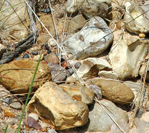
“Uvalde” gravels in secondary context, from gravel bar in Chicolete Creek in souther Dewitt County. Courtesy Glenn T. Goode. |
The Twelvemile Creek chert gravels are clearly alluvial in origin, and were likely gravel bars or channel deposits of a very high energy river in ancient times. Photo by Michael R. Bever.
|
“Uvalde” gravel exposure along Twelvemile Creek, near the Victoria/DeWitt County line. This exposure is within a geologically mapped exposure of the Willis Formation, which consists of Pliocene fluvial sands and gravels. Photo by Michael R. Bever. |
Close up of Twelvemile Creek chert gravels. Cobbles range from 5-20 cm in length, but average around 10 cm (4 inches). Though the pieces are fairly small, flaking quality is good,. They are quite variable in color, indicating they probably derived ultimately (in the Pliocene) from multiple sources. The chert is very similar in size and color to that found in archaeological sites in the area. Photo by Michael R. Bever. |
Sample of ancient gravels from the Willis Formation in Dewitt County, showing that large cobbles and cobbles of fine-grained chert are present in this area. Courtesy Michael B. Collins. |