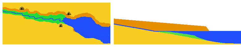
As sea level rose rapidly at the end of the Pleistocene, shorelines around the world moved progressively father inland. By 8,000 B.C. the sea had inundated major river valleys along the Texas coast. The flooding of the valleys of major streams, such as the Trinity, Lavaca, Guadalupe, Aransas, and Nueces Rivers created the earliest forms of our modern coastal bays (respectively, Galveston, Matagorda, San Antonio, Copano, and Corpus Christi Bays). The same presumably occurred at the mouths of the Brazos and Rio Grande Rivers, but the heavy sediment loads (clay, silt and sand) carried by these major rivers have since filled in whatever early bays were created by sea level rise.
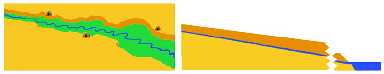
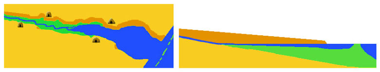
After this time (10,000 years ago), sea level continued to rise for another 7,000 years, but at a slower rate. Many geologists have suggested that rising sea level was not gradual or continuous, but rather that it was intermittent, with periods of rise interrupted by intervals of stable sea level. By around 3,000 years ago (1,000 B.C.), sea level had reached its modern position and has since then been basically stable (though probably with some minor fluctuations). With sea level at a still stand, ongoing wave action and longshore drift deposited sand and shell hash parallel to the mainland, forming the modern chain of barrier islands: Padre, Mustang, San Jose, and Matagorda Islands along the Middle and Lower Texas coast and Galveston Island and Bolivar Peninsula along the Upper Texas Coast.
Archaeological research on the upper and middle portions of the Texas coast has shown that prehistoric human occupation of the shoreline varied markedly in its intensity over that last 10,000 years, the geologic epoch known as the Holocene. Based on the information we have now, the first period of occupation by early people was between ca. 8,200 and 6,800 years ago, after which occupation was relatively sparse. Then there was a major period of shoreline occupation between 6,000 and 4,000 years ago. This was again broken by a one-thousand-year hiatus, during which evidence for occupation is very limited. Starting around 3,000 years ago, or ca. 1,000 B.C., there is again abundant evidence for major occupation, during which time fishing became an increasingly important part of the subsistence economy of the human inhabitants.
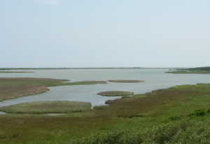
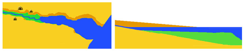
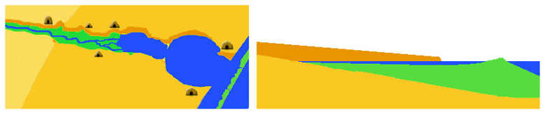
Based on some of the geological estimates of the pattern of sea level rise during the Holocene Epoch, it appears that the three major periods of human occupation and resource extraction along the bay shores corresponded with times of relatively stable sea level. This makes good sense from an ecological perspective, since when sea level was at a still stand, ongoing sedimentation of bay bottoms (as rivers dropped their sediment loads into the bays) created extensive shoreline shallows that supported extensive salt marshes and grass flats. The shallow water had high rates of photosynthesis that, combined the high plant biomass from the marshes and grass flats, produced the organic nutrients needed to sustain high aquatic biomass. These estuaries supported a rich food chain comprised of salt-tolerant plant communities, crustaceans, mollusks and fish.
These rich environments offered prehistoric hunting and gathering peoples a secure subsistence base, which resulted in their establishing camps along bay shores from which they could procure a rich harvest of shellfish and fish. Such encampments are in evidence today as the many archaeological shell middens that dot the shores of the bays and lagoons of the Texas coast.
In contrast, when sea level was rising more or less rapidly, between 6,800-6,000 years and 4,000-3,000 years ago, the extensive shoreline shallows became more deeply submerged, thus reducing photosynthesis and depressing overall biotic productivity, with the result that the bayshores became far less attractive to prehistoric people. Thus we see a marked reduction in archaeological evidence for these periods along the bay shorelines during these periods.
The sea level and bay development patterns outlined here are based on mounting archeological and geological evidence as interpreted by author Robert Ricklis. As the timing of sea level change and human occupation is fine tuned and better known, the localized consequences of “minor fluctuations” may become clear. For example, some geologists have inferred the existence of multiple periods of “high stand” when sea level appears to have been several meters higher than modern levels. These relatively minor fluctuations from the big picture perspectives may well have drastically impacted the human exploitation of specific ecological niches along the coastal zone. Lawrence Aten has argued for such a scenario in the Taylor Bayou area on the uppermost Texas coast. (For details, see the Gaulding site Ancient Place.)
Contributed by Robert A. Ricklis. |