Fieldwork
The Britton, McMillan, and Higginbotham sites lie along a roughly 3-mile-long (5.1 km) segment of the lower North Bosque River. The excavations conducted during the Waco Lake project identified prehistoric components in the upper 3 meters of terrace and floodplain deposits along this stretch of the river. Radiocarbon data indicate these deposits span the Middle Archaic through Late Prehistoric periods. In this section we provide a brief overview of the investigations that revealed this cultural history and summarize the field methods and findings from the current project.
Earlier Investigations
Although Waco Lake was constructed before professional archeological investigations were undertaken, members of the Central Texas Archeological Society surveyed the general vicinity before the lake was built. Frank Bryan was interested in identifying deeply buried sites along streams in the area. Frank H. Watt was especially prolific, with articles on several important sites published from the late 1930s to the 1970s, including the Chupik Site, the Asa Warner site, and Horn Shelter No. 2.
Two expansions of the flood pool at Waco Lake were preceded by professional archeological work. In the 1950s, a survey identified 23 sites, most of which appeared to have Archaic components. Two of the most significant sites subsequently tested were the Baylor (41ML35) and Britton (41ML37) sites. Both had deeply stratified deposits that were used to help establish the cultural chronological sequence for the central Brazos area and central Texas in general. Excavations conducted at the Britton site in 1964 for the Texas Archeological Salvage Project recovered extensive evidence of Late Archaic peoples camping at the site. As reported in a 1965 report by archeologists Dee Ann Story and Harry Shafer, the excavations encountered stratified cultural deposits to at least 3.0 m. In addition to diagnostic artifacts, the excavations produced modified mussel shells and bone artifacts, as well as unmodified faunal remains. The 49 features recorded include ash lenses, hearths, mussel shell concentrations, and a possible multiple dog burial. Four radiocarbon assays yielded ages ranging from 1865 to 2330 B.P., confirming occupations within the Late Archaic period.
Archeological investigations were initiated in 1984 by another plan to raise the lake level. This work entailed an intensive survey of the impact area, providing an overview of all known sites. A total of 83 previously recorded and newly recorded sites were evaluated, and test excavations were conducted at 16 sites, which ranged in age from Early Archaic to Late Prehistoric. After a hiatus of almost a decade and a half, renewed plans to raise the lake level led to limited archeological investigations in 1999 at several sites. As a result, two sites with prehistoric components (Baylor and Britton) were recommended as being eligible for listing in the National Register. Seven other sites appeared to be the best candidates for further work based on their elevations and the impacts anticipated as a result of raising the lake level.
From October 2000 to February 2001, National Register of Historic Places eligibility testing was conducted at nine sites at Waco Lake. Among those investigated, prehistoric sites 41ML160, 41ML162, 41ML185, and 41ML195 were considered eligible for National Register listing based on their good contextual integrity and the presence of stratigraphically isolable components with sufficient quantities of artifacts and other materials for interpretation. Data recovery excavations were recommended at the two most productive and best-dated sites, the McMillan site (41ML162) and Higginbotham site (41ML195), along with two previously declared eligible sites, Baylor and Britton.
Present Investigations
Archeologists from Prewitt and Associates, Inc., conducted investigations at the four sites for several months from October 2002 to July 2003, and August 2004 to January 2005. The project was conducted due to a proposed plan to raise the conservation pool of Waco Lake by 7 feet to 462 feet above mean sea level. The sites were excavated manually as well as with heavy machinery. Intensive testing also was conducted at the Baylor site, 41ML35. Because returns were sparse and chiefly pertained to the Late Prehistoric period, information from this site is not included in this online exhibit.
Large-scale data recovery was conducted at the Britton, Higginbotham, and McMillan sites. Prior to establishing the excavation blocks, the crew dug shovel tests, trenches, and isolated excavation units to help delineate the extent of previously recorded features, define areas with high archeological potential, and provide subsurface exposures for stratigraphic interpretations. Trackhoes were used to dig trenches and, due to the overall depth of some of the excavations, were used to stair-step the edges of the block area for safety.
A total of 4 trenches, and 255 excavation units (each measuring 1x1 meters) were dug at the three sites, and a volume of just over 300 m3 was hand excavated. Nearly 200 features were documented, including burned limestone features (basin-shaped hearths, flat hearths, and discard piles, etc.), stains, evidence of surface fires, charred wood, possible post molds, concentrations of mussel shell, and trash dumps (see Features section and sections on the Britton site, McMillan site, and Higginbotham site for more detail). A variety of chipped-stone artifacts was recovered including both dart and arrow points, bifaces, unifaces, cobble tools with heavy edge wear, cores, utilized flakes, and unmodified debitage. Ground stone (manos and metates used for grinding) also were recovered, although in limited numbers.
During excavations, samples were taken for a variety of special technical studies, including mussels for seasonality study (stable isotope analysis) and point-provenienced charcoal for radiocarbon dating. Samples of sediment were collected for particle size analysis and chemical analysis. Matrix also was collected from within features for flotation, in order to recover macrobotanical and and other remains. Samples of burned rocks were collected for lipid residue analysis.
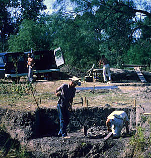
Initial excavations at the Britton site were conducted in 1964 by the Texas Archeological Salvage Project at the University of Texas at Austin. Shown working in this photo are Harry Shafer and Gary Swenson. TARL Archives.

|
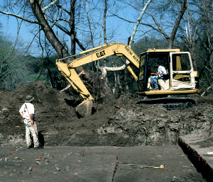
Mechanical excavations at the Britton site, 2002. Trackhoes were used to dig trenches and, because of the proximity of the site to the river’s edge, to stair-step the edges of the block area for safety. |
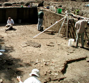
Prewitt and Associates crew working within one of the large excavation blocks at the Britton site. Broad horizontal exposure of the site helped reveal potential occupation surfaces and patterns among features and artifacts. In this photo, at least five different features, or activity areas, can be seen.
|
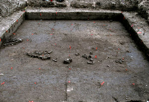
Completed excavation block. Red flags mark the corners of each of the contiguous 1x1-m units within the block. Throughout excavation, plan views showing features, unique artifacts, and other significant materials were drawn to document each 10-cm level in each of the units.
|