Strong winds picking up fine sand from sand bars
on the wide, inside bends of the Red River in the Great Bend area. Photo by
Frank Schambach.
The Red River is the central feature of the Caddo Homeland and its largest river, the last (southernmost) major western tributary of the mighty Mississippi. The Caddo occupied about a 250-mile stretch of the Red, from Fannin County, Texas to just below Natchitoches, Louisiana. The Great Bend of the Red River was one of the core areas of Caddo settlement throughout Caddo history.

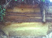
Bank of the Red River near Texarkana. The alternating
bands of clay and sand visible in the bank represent floods that gave
life to the river's floodplain and sometimes ruined the crops of Caddo
farmers. TARL archives.

