Background, Models, and Methods
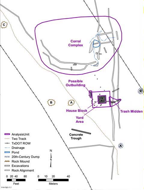
This map shows all of the documented large-scale features and completed archeological excavations in the southeastern portion of Ransom Williams' 45-acre farm but within the right of way for the proposed SH 45 Southwest. All of the cultural features date to the nineteenth century and are associated with the Williams occupation, except for two isolated trash dumps and a concrete livestock feed trough that date after the family left the farm in 1905.
Farmsteads as SystemsThe way we investigate historic farmsteads has evolved considerably in the last 20 years. As archeologist Mary Beaudry and others increasingly maintain, historic farmsteads are complex systems that can only be understood when viewed from a landscape perspective. You cannot understand the whole farm if you look only at the farmhouse. A true understanding of a farming operation requires a detailed examination of the relationships between all of the features and components that comprise the entire system. Beaudry stresses that farmsteads are not a snapshot in time. Rather, most farms evolved over many decades in response to various outside factors such as changing technologies, long-term weather cycles, and local, state, and national events. Many historic farms in Texas have been in operation for nearly a century and represent a continuum of a constantly evolving system. In contrast, the Williams farmstead was in operation for only three decades, which is a relatively brief period in time. The historical and archeological evidence from the site document the occupation of a single family during last quarter of the nineteenth century—a time when industrial and agricultural technologies were changing dramatically.
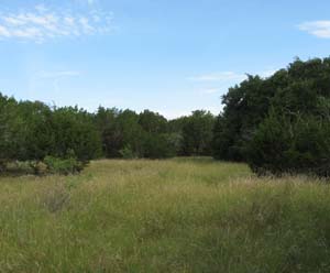
The archeological evidence was examined at multiple scales. Investigations of the house complex entailed extensive archeological excavations of the house, yard area, and closely associated features, with spatial analyses being done within excavation blocks and comparisons made between excavation blocks. The landscape analysis focused on the entire farm property and the large-scale features, but was augmented by various levels of spatial analyses of the material remains. The varying levels of analysis, from small features to the entire farm, proved to be very productive. These studies provide evidence of how Ransom Williams organized his farm to take full advantage of the landscape and natural resources available on and near his property. Prewitt and Associates, Inc. conducted archeological testing in 2007 and 2008 to investigate the archeological integrity of the farmstead site. It was quickly determined that the house site was relatively intact. The rock chimney and large foundation stones delineated the approximate location where a wooden house had stood, and the work revealed intact archeological deposits with numerous nineteenth-century artifacts. Around the house were indications of a possible outbuilding foundation, a substantial trash dump (what archeologists call a “midden”), and some old rock alignments. When we looked at the entire farmstead property, rock alignments were found on the borders of the property, and large walls of stacked limestone rock fences were found along the edges of a heavily wooded area downslope and north of the house. A study of the onsite vegetation patterns, in comparison with historic and modern aerial photographs, revealed the locations where fields had been cleared long ago as well as areas that were left wooded to serve as livestock pasture. Data RecoveryOnce a plan was in place, the project moved into the “data recovery phase.” This intensive archeological work included a landscape analysis of the whole farmstead. We were limited to the area inside the state-owned road right of way, which was only about 37 percent of the 45-acre farmstead, but the state property did include the most archeologically important parts of the farm. Detailed site mapping, documentation of surface artifacts, and investigation of the large features and vegetation patterns (old trees) revealed many details about how Ransom Williams laid out his farm. A system of large rock walls was determined to be a corral complex and livestock fences, and excavations revealed where Ransom Williams had dug a pond to trap water for his livestock. The archeological work also included intensive hand excavations focused on the house site, surrounding yard area, a possible outbuilding location nearby, and the large trash dump (midden). When the data recovery work was completed, we had excavated 142 units (each 1x1 m) and mapped numerous features that fully defined the house area and the corral complex that comprised the main activity areas at the farmstead. This effort defined the historic farm landscape and allowed us to clearly see and understand the logic behind Williams' decisions in selecting the house location and laying out the components of the farmstead (e.g., fields, pastures, corrals, outbuildings). The 2009 data recovery investigations recovered more than 26,000 artifacts, and virtually all of them are items used and left behind by the Williams family. These findings are quite different from those at another freedman farmstead site in Travis County investigated by TxDOT as part of a road project in the 1990s. The Rubin Hancock family lived on their farm from ca. 1880 to 1916, but the property was occupied and used by other people before and after that time, so many of the artifacts found there may not have belonged to the Hancock family. In contrast, the archeological remains at 41TV1051 were almost exclusively associated with the 30-year occupation of the Williams family from ca. 1871 to 1905. The integrity of the evidence has provided an unusual opportunity for research into life at the freedman farm and comparisons with other sites in the future.
|
The Williams farmstead was discovered and examined by archeologists in 2003 during the initial survey of the route of a proposed toll road called State Highway 45 Southwest. The Texas Department of Transportation (TxDOT) then contracted with the Austin firm of Prewitt and Associates, Inc. (PAI) and this ultimately led to more than six years of rigorous investigations combining archeology, oral history, and archival research. The site, designated 41TV1051, sat squarely in the footprint of the proposed SH 45 Southwest roadway, and there was no doubt that most of it would be destroyed when the road was built. TxDOT, PAI, and the Texas Historical Commission (THC) realized this was a rare opportunity to conduct a comprehensive archeological investigation of an almost pristine, post-Emancipation, freedman-owned farmstead in Texas.
|