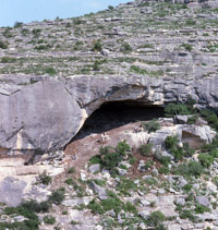
Field Strategy
The looters' potholes observed in our first visit to Hinds Cave in 1974 exposed deep deposits of perishable materials, including desiccated human feces or coprolites. With this in mind, the 1975 excavations targeted areas where intact layers of botanical remains and coprolites appeared to remain in stratified context. The walls of looter holes were cleaned up and the resulting stratigraphic exposures were used to guide the excavations. Area A targeted a deep fiber deposit for the recovery of botanical remains. Area B targeted both botanical remains and coprolites. Area D was dug to probe the depth of the cave deposits in the vicinity of Area A.
Area A was exposed on the west and south sides by the deep and extensive looting that had removed the upper meter or so of the fiber deposits in the heart of the living area of the cave. The looter holes were cleaned out and their contents screened through ¼-inch mesh. While the recovered material was from mixed deposits, it did yield artifact styles that added to our knowledge of the site chronology.
We cleaned back and straightened out looter holes and excavated several narrow units to isolate a raised block containing intact deposits, Block A. These exploratory units were excavated in natural layers defined by changes in color and texture. We used the term “lens” to identify each layer and numbered these sequentially from the top in each area. Once Block A was completely isolated, each of the block walls were carefully drawn to provide a record of the stratigraphy to guide the excavation. Block A, which was about 1.5 meters (5 feet) square, was divided into east and west halves each half was excavated by peeling off and bagging the content of each lens to maintain the stratigraphic integrity. Any changes in the stratigraphy seen in the excavation were noted on the profiles as recovery proceeded.
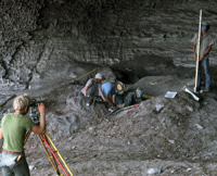
Block B was isolated in a similar fashion. A series of units were excavated on three sides to isolate the block; the rear wall of the cave formed the southwest side. The same strategy used to excavate the units bordering Block A was employed in Area B as well. Once Block B was isolated, its walls were profiled (drawn) and once again used as a guide during the excavation of the block by natural layers.
Unit D, a 1-x-2 meter unit, was excavated from the bottom of a pothole to determine the depth of deposits beneath Block A. The block, as it turned out had sampled only the upper half of the deposits. In this area, the floor of the shelter was encountered at a depth of 3.2 meters beneath the estimated original surface (prior to looting). Unit D exposed a thick burned rock midden layer beneath the meter-thick upper fiber zone, and determined that perishable materials were recoverable throughout the fill to the cave floor. This unit proved to be highly informative in other respects. Two previously unreported sandal types, well-preserved coprolites, a variety of other perishable artifacts came from this test and radiocarbon sample from a lower lens yielded a date of 8,280+80 BP (calibrated mid-point, 7300 B.C.).
In the 1976 season, the last major field session, we continued to follow the same basic excavation strategy. Work continued apace on the blocks in Areas A and B. Excavating and sampling the stratified latrine layers in lower deposits in Block B was a major focus. A small unit dug the previous year as Area C was expanded to sample undisturbed deposits at the rear of the shelter. Several excavation units were joined together to form the A-C Trench, connecting Areas A and C.
The 1976 season also saw considerable effort outside Hinds Cave. Survey work identified open campsites and chert outcrops. Special studies were carried out to quantify the resources available in local plant communities. Natural water sources were sampled to provide background pollen samples. These studies helped put Hinds Cave in perspective and give us a better appreciation of the natural resource structure.
Short field sessions were carried out in 1977-1978 by small teams of graduate students to obtain final samples and clarify the stratigraphy of the site. The A-C Trench was completed and profiled. Radiocarbon samples were collected from the deep walls of the trench. A bitterly cold week in January, 1978 proved to be the last work session at Hinds Cave.
Some years later in 1983-1984, Joe Saunders of SMU carried out additional intensive survey of Hinds Ranch and of a more distant upland area termed the Blue Hills. This work documented open campsites as well as scattered finds in an effort to sample the wider local landscape across which the prehistoric groups who visited Hinds Cave lived.
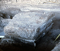
Block A was isolated on three sides. The clearly visible layers of stratigraphy were then used to guide the excavation. TAMU Anthropology archives.
Short summaries of each excavation area at Hinds Cave are linked to the Explore Hinds Archeology maps.