The Prehistory of the Texas Coastal Zone: 10,000 Years of Changing Environment and Culture
The story of prehistoric human culture on the Texas coast is about how hunting and gathering (non-farming) populations adapted to the opportunities and constraints of their shoreline and nearby prairie environments using limited technology bolstered by first-hand knowledge about the location and seasonal availability of important subsistence resources.
When European explorers and colonists first arrived in the region, beginning in the 1500s, the indigenous coastal peoples (Karankawa, Akokisa and other tribal groups) practiced a mix of subsistence economies: intensive fishing in the shoreline bays and lagoons, hunting of deer, antelope, and bison that foraged and grazed on the prairies and woodlands of stream floodplains, and gathering of a wide range of aquatic and terrestrial plant foods.
The bays were located behind barrier islands that offered protection from the high-energy wave action of the open Gulf of Mexico. The shallow-water bay environments were rich in fish such as black drum, redfish, speckled sea trout, Atlantic croaker, and marine catfishes that could be taken in huge numbers by netting or by shooting with bow and arrows. Shellfish, including bivalves (oyster, clams, scallops) and gastropods (whelks and conches) could be readily gathered from the shallow bottoms of the bays and lagoons to obtain edible meat and shells that could be used to make a variety of tools and ornaments. Game, especially larger mammals (deer, antelope, bison) were abundant on the mainland, and were a major source of meat protein, fat, hides, and bones that were, like shell, useful in the production of tools and ornaments.
The coastal zone was, in effect, a broad ecotone, a transitional boundary between two major biophysical provinces, the marine environment of the Gulf of Mexico, and the terrestrial environment of the flat coastal prairies. As such, the region provided indigenous peoples with a range of choices and opportunities in terms of economic resources. At the time of initial contact with Europeans, the coastal tribes must have placed great value on the abundant opportunities that existed within their homelands, and they maintained clear territorial boundaries between their lands and those of Native peoples living in the interior. Such was the richness of their environment that coastal population density was relatively high, and people spent much of the annual cycle living in large shoreline fishing camps that housed several hundred people during peak fishing seasons.
Dominant Environmental Factors
The coastline as we see it today is, from a geologic perspective, a very recent phenomenon that dates back only about 3,000 years. In fact, prior to around 8,000 B.C., the area of the modern shoreline was high and dry, with the Gulf coast far to the east of its present position. This is because, in earlier millennia, global sea level was as much as 100 meters (over 300 feet) lower, with much of the world’s water supply “locked” in vast continental ice sheets and montane glaciers that were far more extensive than those of modern times. This era, the Pleistocene (or, in common parlance, the “Ice Age”) had markedly lower global temperatures than those of historical times. The final cold phase of the Pleistocene was around 20,000 years ago, after which rising global temperatures caused the continental ice sheets and mountain glaciers to begin a gradual melting process, with the result that sea level began to rise rapidly over the next 10,000 years.
As sea level rose, shorelines around the world moved progressively father inland. By 8,000 B.C. the sea had inundated major river valleys along the Texas coast. The flooding of the valleys of major streams, such as the Trinity, Lavaca, Guadalupe, Aransas, and Nueces Rivers created the earliest forms of our modern coastal bays (respectively, Galveston, Matagorda, San Antonio, Copano, and Corpus Christi Bays). The same presumably occurred at the mouths of the Brazos and Rio Grande Rivers, but the heavy sediment loads (clay, silt and sand) carried by these major rivers have since filled in whatever early bays were created by sea level rise.
After this time, sea level continued to rise until relatively recently, but at a slower rate. Many geologists have suggested that rising sea level was not gradual or continuous, but rather that it was intermittent, with periods of rise interrupted by intervals of stable sea level. By around 3,000 years ago (1,000 B.C.), sea level had reached its modern position and has since then been basically stable (though probably with some minor fluctuations). With sea level at a still stand, ongoing wave action and longshore drift deposited sand and shell hash parallel to the mainland, forming the modern chain of barrier islands (Padre, Mustang, San Jose, and Matagorda Islands along the middle and lower Texas coast and Galveston Island and Bolivar Peninsula along the upper Texas coast). For additional diagrams charting these environmental changes, see Changing Sea Level and the Evolution of the Modern Coastal Environment.
Archeological research on the upper and middle portions of the Texas coast has shown that prehistoric human occupation of the shoreline varied markedly in its intensity over that last 10,000 years, the geologic epoch known as the Holocene. Based on the information we have now, the first period of occupation by early people was between ca. 8,200 and 6,800 years ago, after which occupation was relatively sparse. Then there was a major period of shoreline occupation between 6,000 and 4,000 years ago. This was again broken by a one-thousand-year hiatus, during which evidence for occupation is very limited. Starting around 3,000 years ago, or ca. 1,000 B.C., there is again abundant evidence for major occupation, during which time fishing became an increasingly important part of the subsistence economy of the human inhabitants.
Based on some of the geological estimates of the pattern of sea level rise during the Holocene Epoch, it appears that the three major periods of human occupation and resource extraction along the bayshores corresponded with times of relatively stable sea level. This makes good sense from an ecological perspective, since when sea level was at a still stand, ongoing sedimentation of bay bottoms (as rivers dropped their sediment loads into the bays) created extensive shoreline shallows that supported extensive salt marshes and grass flats. Also, the shallow water had high rates of photosynthesis that, combined with the high plant biomass from the marshes and grass flats, produced the organic nutrients needed to sustain high aquatic biomass and a rich food chain comprised of salt-tolerant plant communities, crustaceans, mollusks and fish. These environments offered prehistoric hunting and gathering peoples a secure subsistence base, which resulted in their establishing camps along bayshores from which they could procure a rich harvest of shellfish and fish. Such encampments are in evidence today as the many archeological shell middens that dot the shores of the bays and lagoons of the Texas coast.
In contrast, when sea level was rising more or less rapidly (between 6800-6,000 B.P. and 4,000-3,000 B.P.), the extensive shoreline shallows became more deeply submerged, thus reducing photosynthesis and depressing overall biotic productivity, with the result that the bayshores became far less attractive to prehistoric people. Thus we see a marked reduction in archeological evidence for these periods along the bay shorelines.
Review of the Archeological Evidence
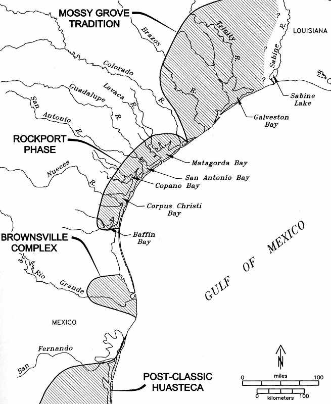
Archeologically, the Texas coast has been traditionally divided into three basic sections. The upper coast extends from the Sabine River/Sabine Lake area at the Louisiana state line westward to include the Galveston Bay area, and then southward to the vicinity of the mouths of the Brazos and Colorado Rivers. Shell middens are reported in abundance in the Sabine Lake area and along the shorelines of Galveston and Trinity Bays, and camp and burial sites are also reported from Bolivar Peninsula and Galveston Island. The central coast begins at this point and extends south to the northern shoreline of Baffin Bay. Shell-midden sites in this area are found along the shores of all the bays, as well as on the leeward shorelines of the barrier islands. The lower coast extends from the southern shoreline of Baffin Bay down to the Rio Grande Delta area. Shell middens are scarce in this sub-region because the waters of Baffin Bay and Lower Laguna Madre are too saline (hyper-saline) for oysters and other mollusks to survive. Economically useful fish species such as black drum, redfish and sea trout, however, do well, and fish remains are found in abundance in Archaic and Late Prehistoric campsites along Baffin Bay, Laguna Madre, and in the Rio Grande Delta area.
While each of the three coastal areas has its own distinctive archeological and environmental characteristics, there are fundamental features, especially environmental ones, that are common to all. In the remainder of this section, we will summarize the major culture periods for the Texas coast, while pointing out those cultural elements that tend to characterize each area.
Paleoindian: Before the Formation of the Modern Coastline
As elsewhere in Texas, the earliest universally accepted evidence for human occupation falls into the Paleoindian period, ca. 11,000-7,000 B.C. These several thousand years of early human presence are represented by surface finds of several types of highly diagnostic chipped-stone dart points, including Clovis, Folsom, Golondrina, St. Mary’s Hall, Wilson and Scottsbluff. These time-diagnostic points have been documented at a number of sites on the coastal plain, including Buckeye Knoll and the McNeil Ranch Site on the lower Guadalupe River and the well-known McFaddin Beach Site on the upper coast. However, the archeological evidence from such sites does not represent shoreline occupation or exploitation of coastal resources. The locations where Paleoindian artifacts have been found would all have been quite far inland, given that sea level was much lower than today and the Gulf coastline was significantly farther out that it is now. Whether or not Paleoindians frequented the coastline of their day to fish and gather shellfish remains an open question, one that can be answered only by future study of submerged landforms now under Gulf marine waters.
Early Archaic: Initial, Limited Occupation of the Coast
The Early Archaic in the coastal zone dates to between ca. 7,000 and 4,000 B.C. As already mentioned, it was during this period that we have the earliest evidence for human occupation of the coastline in the form of midden deposits composed of the shells of bivalves such as rangia clams and oysters. After the initial formation of the bays due to rising sea level around 9,000 to 10,000 year ago, there was infilling as sediments dropped by rivers discharging into bays accumulated in the bottoms. By the time of the Early Archaic, the waters around the inland heads of the bays had become shallow enough to support the nutrient-rich marshes and grass flats that are the crucial requirement for high biotic productivity that attracted prehistoric people to the shorelines.
Known sites of the period, all along the central coast, include the Kendrick’s Hill Site (41JK24) near Lavaca Bay, excavated by Richard Weinstein, and several sites on Nueces Bay investigated by Robert Ricklis. The deepest and oldest layer of shell midden at Kendrick’s Hill, a thin but dense deposit of rangia clam shells, was radiocarbon dated to 8,200 years B.P. (ca. 6,200 B.C.). At three sites (41SP136, 41NU153 and 41NU266) on bluffs overlooking Nueces Bay (a secondary bay connected to Corpus Christi Bay), the basal strata consist of thin layers of oyster shell.
Artifacts are scarce in all these deposits and consist, at most, of a smattering of chert debitage, an occasional utilized chert flake and, at 41SP266, a fragment of an edge-flaked sunray venus clam shell knife or scraping tool. Along with the thinness (5-15 cm thick) of the shell deposits, the paucity of artifacts indicate short-term occupations that involved little on-site activity other than gathering and consuming clams and oysters.
Animal bones have not been found in these early shell deposits, doubtless because they have decayed over the last seven thousand years. A few fish otoliths, more resistant to decay than bone, have survived, indicating that limited (non-intensive) fishing was part of the subsistence strategy of Early Archaic people who lived along the bay shores.
The basic picture of Early Archaic use of the coast is of small groups setting up short-term camps for the purpose of gathering clams and oysters and engaging in limited fishing activities. Probably, some hunting of game was done, as well.
Although, so far, no projectile points have been found in excavated contexts, a few examples of points of this time period have been recorded as surface finds. These seem to be materials that have eroded from Early Archaic shell middens exposed by natural and/or artificial ground disturbances. It reasonable to assume that some hunting was done from these locations. We can also infer that various species of edible plants were gathered and eaten, as well.
Many, perhaps most, of these early shoreline camps were probably set up by small task groups coming from inland areas. Evidence from the Buckeye Knoll Site (41VT98) appears to corroborate such this suggestion. At Buckeye Knoll, located near the banks of the Guadalupe River about 25 kilometers upstream from the head of San Antonio Bay, a large Early Archaic cemetery was discovered and partially excavated, resulting in the documentation of the skeletal remains of some 90 individuals. Radiocarbon dates on small samples of tooth pulp from many of these individuals place this cemetery at between ca. 7,000 and 6,200 years ago (ca. 5000-4200 B.C.). Analysis of stable isotopes in the tooth pulp (N15 and C13) showed that the diet of these folk consisted of a mixture of terrestrial, riverine, and marine food resources, meaning that they must have moved between the interior and the coast in their subsistence strategy. A part-time use of coastal resources (fish, shellfish) by peoples living in the adjacent interior environment fits with the evidence for short-term camps on the shoreline obtained from the kinds of sites just mentioned.
Middle Archaic: Increasing Intensity of Coastal Occupation and Resource Use
During the Middle Archaic, between around 6,000 and 4,000 years ago (4000-2000 B.C.), evidence for human occupation of the shorelines shows a dramatic increase. Campsites along the central coast are more abundant, and the first radiocarbon-dated shell middens known for the upper coast appear. Also, some sites have yielded a greater quantity of artifacts, including stone dart points of types such as Bell, Andice, and Early Triangular, as well as scrapers. Numerous shell strata at sites on Nueces Bay have been dated to this period, including the McKinzie Site (41NU221) where excavations recovered several dart points, a unifacial scraper, a fragment of a Clear Fork gouge, edge-utilized flakes of chert, and a flake of obsidian suggesting as-yet poorly understood long-distance exchange during the Middle Archaic. Although bone was not preserved at McKinzie, otoliths representing black drum, redfish, sea trout, and marine catfish indicate some importance for fishing along with the gathering of Rangia flexuosa clams, the shells of which were the dominant species.
The Means Site (41NU184), another dense Rangia flexuosa midden, has been radiocarbon dated to 5300 years B.P. (3300 B.C.), in association with fish otoliths and numerous examples of Early Triangular dart points. Numerous sites near the shoreline of Nueces Bay contain shell strata dating to this period, as do a number of sites in the Galveston Bay area on the upper coast, as well as clay dune sites on the northern shore of Baffin Bay. It is apparent that the entire Texas coast was occupied at this time, and a general increase in the number and range of artifacts on these sites suggests more intensive occupations involving more on-site activities than was the case during the Early Archaic.
Site 41KL71, on a clay dune on the northern shore of Baffin Bay contains several discrete strata of archeological debris, the lowest of which contained a very thin lens of oyster shells and charcoal dating to around 5300-5900 b.p., or ca. 3300-3900 B.C.
On the upper coast, a number of shoreline shell middens in the Galveston Bay area have been dated to this period. These deposits are dominated by oyster shells. Similarly, to the south on the north shore of Baffin Bay, several oyster shell deposits also date to the Middle Archaic. This indicates that the hypersalinity (over 60 parts per thousand) that came to characterize Baffin Bay in more recent times, conditions under which oysters and other mollusk cannot survive, did not yet exist. This is probably because the Padre Island barrier had not yet fully formed, so that marine waters of the open Gulf, which have salinity much lower (36 parts per thousand) than do Baffin Bay and Laguna Madre today, freely entered the bay via wave action and tidal influence.
Coastal Occupation Hiatus, ca. 2,000-1,000 B.C.
With over 200 radiocarbon dates available from shell middens along the Texas coast, from Galveston Bay on the upper coast southward to Baffin Bay, a striking pattern can be seen: throughout this long stretch of coastline, there is a notable gap in dates between 4,000 and 3,000 years ago. This suggests a marked break in human occupation of the shoreline that lasted roughly one millennium. Inferably, for some reason the coast became unattractive as a place to live for hunting and gathering populations, perhaps because the food resources that attracted people to the shoreline—fish and shellfish—were either no longer available, or had suffered a decline in abundances that caused the bay shores to be too poor in resources to support resident human populations.
Geological research by Jeffrey Paine has suggested that there was a rapid rise in sea level to a high stand (higher-than-modern sea level) at this time. Rapidly rising sea level would have destroyed the extensive bay shallows that were crucial for providing organic nutrients that supported the biotic food chain, causing a dramatic reduction in populations of primary and secondary consumer species (i.e., crustaceans, mollusk and fish), thereby rendering the bays unsuitable for sustaining human economic activities.
Late Archaic: Stabilization of Sea Level and Intensification of Human Coastal Resource Use
Geological studies have shown that by 3,000 B.P., or 1,000 B.C., sea level became stable at its modern position. While there have been some minor fluctuations in sea level since that time, they have not been of sufficient magnitude to cause any major disruptions in the ecology of the coastal bays and lagoons. Ongoing deposition of sediments by wave action and longshore drift created the modern barrier island chain a few kilometers offshore. Broken only by a series of tidal passes, the barrier islands protect the bays and lagoons from high-energy wave action, and the accumulation of river-deposited sediments within the bays re-established the extensive shallows that provided organic nutrients in the form of decaying plant matter. This resulted in dramatic increases in the abundances of the shellfish and fish species that were economically useful to human populations, and there was, in turn an increasingly intensive exploitation of these resources, culminating, by the end of the Late Archaic, in a peak in fish as a human dietary staple.
Shoreline shell middens of this period are more numerous than for all earlier periods, and sites are much larger, with thicker accumulation of shell and other occupation debris. On the central coast, the Kent-Crane Site (41AS3) on Copano Bay is a shell midden over 5 feet thick that extends along a shoreline bluff for nearly a kilometer. Excavations carried out here in the early 1940s under the Works Progress Administration (WPA) recovered many stone tools, including dart points of typical Late Archaic types, and many shell tools including conch-shell adzes and gouges, sunray venus clamshell scrapers, and perforated oyster shells (thought to be net weights). The outer body whorl sections of whelk shells were also used to make pendants and other items of personal adornment. Bone artifacts include awls and pins with engraved decorations made from deer long bone splinters, as well as beads fashioned from tubular sections of bird bones.
Also recovered were fragments of asphaltum, a black tar-like substance that originates from petroleum seepages in the floor of the Gulf of Mexico and washes onto Gulf beaches on the barrier islands. This material was collected by Late Archaic people for use as a coating on baskets (some of the Kent-Crane specimens have clear impressions of woven basketry) as well as a glue for securing projectile points to wooden shafts (many of the dart points from Kent-Crane have traces of asphaltum still adhering to the basal sections that were inserted into the wooden foreshafts of darts). Radiocarbon dating on shells from the bottom of the Kent-Crane midden produced an age of ca. 800 B.C. for the beginning of intensive occupation at the site.
The Mustang Lake Site (41CL3) is a massive Late Archaic shell midden on the shoreline of an salt-water inlet of that name that is connected to San Antonio Bay. This site extends along the Mustang Lake shoreline for a distance of about 1.5 kilometers, and, where tested by excavation, attains a thickness of approximately 5 feet. Consisting mostly of densely packed oyster shells, this deposit has also yielded profuse quantities of fish bones, and a series of radiocarbon dates, the earliest of which falls, as in the case of Kent-Crane, at ca. 800 B.C. Hundreds of perforated oyster shells and other tools of shell, such as conch columella gouges and conch-shell hammers, can be seen along the shoreline beach, where wave action has eroded the edge of the midden.
Not all shoreline sites on the central coast of this period are as large as Kent-Crane and Mustang Lake, but even smaller sites cover thousands of square meters and contain densely packed shells of oyster and other species along with large quantities of fish bones and otoliths, along with stone and shell tools. Examples are the Swan Lake Site (41AS16) on Copano Bay, the Guadalupe Bay Site (41CL2) on Guadalupe Bay (an inland extension of San Antonio Bay), the Kendrick’s Hill Site (41JK24) near Lavaca Bay, and the Ingleside Cove Site (41SP43 and 41SP120) on the northeastern shore of Corpus Christi Bay.
On the upper coast, the Late Archaic is represented by dozens of known shell midden sites along the shorelines of Galveston and Trinity Bays, as well as Clear Lake, a secondary bay connected to Galveston Bay. Mostly, these are dense deposits of Rangia cuneata clam shells, among which are often found oysters and shells of other bay species. These sites generally cover several thousand or more square meters and excavations have recovered various Late Archaic chipped-stone dart points and other tools, shell and bone tools and ornaments, and the bones of fish, turtle, deer and other terrestrial species.
The Archaic of the lower coast remains very poorly known. Late Archaic sites are documented but few have received even minimal archeological investigation. Generally, these sites are not shell middens, probably because shellfish-gathering opportunities along the coastline were limited by environmental conditions (such as hypersalinity) not supportive of oyster and other species. Fish bones and otoliths are abundant at many sites, however, so it is likely that fishing was an economic mainstay in this area as it was to the north. Recent doctoral research by Tiffany Terneny has shown that cemetery sites in the Rio Grande Delta area, once thought to be associated strictly with the Late Prehistoric Brownsville Complex, had been used well back into the Late Archaic, and that some of the array of shell ornaments previously assigned to the later period actually were being produced by Late Archaic people living and burying their dead in this region.
Late Prehistoric Period: Intensive Fishing, Coastal Territories, the Bow and Arrow and Pottery
As is the case in much of Texas, the Archaic ends, and the Late Prehistoric begins, with notable changes in aboriginal technologies. The foremost of these, and the ones that are particularly easy to detect in the archeological record, were the introduction of the bow and arrow, which replaced the atlatl and dart as the primary weapon for hunting (and warfare), and ceramic technology, wherein containers of various functions (cooking, serving, storage) came into widespread common use.
Based on our present knowledge, the bow and arrow was introduced along the coast around the same time it appeared in the interior of Texas, ca. A.D. 800-1,000. Scallorn arrow points, which are securely dated to this time in central Texas, were used along the upper coast and the northern part of the central coast. Farther south, in the Corpus Christi area, this type is not very common, and un-notched/unstemmed triangular arrow points, assignable to the Fresno type, have been found to be the earliest arrow point style at 41SP120 on Ingleside Cove, where they have been dated to ca. A.D. 1000-1250. Still farther down the coast, various unstemmed and un-notched arrow point types, such as Cameron, Starr, and Lozenge, predominate, though their exact date of appearance has yet to be determined.
Ceramic technology appears earliest on the upper Texas coast, where early pottery types now appear to date to perhaps as early as several centuries B.C. Lawrence Aten, in his seminal study of the culture history of the Galveston Bay area, proposed that the earliest pottery in that area, a form of Tchefuncte ware, closely related to pottery of the same name to the east in Louisiana, was introduced by A.D. 100. More recent excavations at the Eagles Ridge Site (41CH252) near the Trinity River delta produced large numbers of sherds of Tchefuncte pottery in levels radiocarbon dated to as early as around 400 B.C.. This finding suggests that the Tchefuncte pottery of the upper Texas coast is as old, or nearly as old, as that from Louisiana, further suggesting that the peoples in both areas were closely related and were in more or less continuous communication.
By the early centuries A.D., upper Coast pottery began to undergo its own stylistic and technological changes, and pottery assemblages from sites in that region came to be dominated by sandy paste ceramics of the Goose Creek series. Pots were commonly undecorated (Goose Creek Plain), and sometimes adorned with geometric patterns of incised lines (Goose Creek Incised). The Hopewellian stylistic expressions of the Marksville Culture pottery of Louisiana had little if any influence on early Goose Creek ceramics, suggesting a period of relative isolation from eastern influences in the early centuries A.D.
By around A.D. 1000, however, this had changed, and upper coast incised designs came to closely resemble the decorative patterns on the Coles Creek, and slightly later Plaquemine traditions of Louisiana and the Lower Mississippi Valley. After ca. A.D.1000, some upper coast pottery came to be tempered with grog (crushed pottery), a technology presumably borrowed from Louisiana, and this is called Baytown Plain, if undecorated, and San Jacinto Incised, if it bears incised decorations. The decorative motifs on San Jacinto Incised are similar to those on Goose Creek Incised.
The recurrent interactions between the people of the upper Texas coast and those to the east in Louisiana is almost certainly also reflected in the cultural geography of Early Historic times. This is expressed in the historical fact that the Akokisa and Bidai Indians of the Galveston Bay area and the adjacent interior shared a common linguistic tradition with the Atakapa Indians of south-central and southwestern Louisiana.
By 1250 A.D. pottery technology had reached in the central coast. Sandy paste wares similar to Goose Creek Plain of the upper coast have been found at 41JK8 on the lower Lavaca River in association with Scallorn arrow points. The people of the central coast, probably ancestral to the historic Karankawa tribes, were making a distinctive pottery by A.D. 1250-1300. This pottery, known as Rockport Ware, is a distinctive trait of the Rockport Phase, which has been linked with the Karankawa. It is a thin, sandy paste pottery that is sometimes undecorated (Rockport Plain), sometimes decorated with incised markings (Rockport Incised) almost certainly inspired by upper coast styles, but most frequently coated and/or decorated with asphaltum. Decorations consist of narrow bands of asphaltum painted along the rims of pots. In some cases, vertically oriented sets of parallel squiggly lines are added, and these descend along the outside of jars and ollas (narrow-mouth vessels). Interiors of these pots were often coated with asphaltum, perhaps as a sealant, and exteriors were sometimes partially or completely coated, as well.
Rockport pottery is typically a central coast phenomenon, as it is commonly found from Matagorda Bay in the north to the northern shore of Baffin Bay, some 150 kilometers to the south. As such, its distribution is essentially the same as the known range of the Early Historic Karankawa tribes. The fact that Rockport pottery is found in abundance at the sites of Spanish Colonial missions and presidios where Karankawas are known to have been the primary Indian residents (such as the missions of Nuestra Señora del Rosario and Nuestra Señora del Refugio, and the earliest location of Presidio La Bahia) further supports the linkage of this pottery, and the Rockport Phase, with the Karankawa Indians of Colonial times.
No indigenous pottery has been found at sites on the lower coast, where it was never locally produced. Occasional examples of Post-Classic Huastecan ceramics have been found in the Rio Grande Delta area, where pots arrived via trade between local Late Prehistoric populations and the Huastecan people living along the coastal plain in the northeasternmost section of Mesoamerica. It is thought that the local Rio Grande delta folk may have exchanged shell ornaments for pots and perhaps other items, such as jadeite ornaments that have been found, albeit rarely, at sites of the Brownsville Complex.
By Late Prehistoric times the population density of coastal groups was probably growing rather rapidly, sustained by the abundant food supply made possible by intensive fishing. In addition to fish, the Natives of the central coast, and to some degree the upper coast as well, found a rich source of meat and protein in the herds of buffalo that had expanded onto the Texas coastal prairies after around A.D. 1250. Bison bones have been found at numerous Rockport Phase hunting camps located on prairie uplands overlooking the rivers and creeks that flow across the coastal plain. Such sites are all within around 40 kilometers from the mainland coastline, which is the same distance inland noted as the territorial limits of the Karankawa tribes by Euro-American observers in Early Historic times.
The Rockport Phase/Karankawa people maintained a rather strict territorial boundary at this distance from the coast, and were able to find bison and other key resources (such as chert for making stone tools) within this territorial boundary. Seasonality studies of fish otoliths and oyster shells suggest that the major fishing camps were occupied by up to several hundred people during the fall through early spring, and that populations fissioned into smaller kin groups during the late spring and summer to move inland along streams to hunt deer and buffalo. This pattern of seasonal settlement and mobility is supported by Spanish Colonial archival documentation. Immediately inland from the Karankawa were various groups of quite different linguistic, ethnic and cultural identity, who at least in large part were the carriers of the cultural pattern associated archeologically with the Toyah Horizon. The Rockport Phase is distinguishable primarily on the basis of its abundant asphaltum-coated/decorated pottery, which is stylistically distinct from the bone-tempered plain pottery made by Toyah groups.
Although the coastal-interior cultural boundary is identifiable on the basis of the distributions of Late Prehistoric pottery traditions, it was not impermeable. The 16th-century Spaniard, Cabeza de Vaca, noted in his Relación that Natives of the central coast had peaceful interactions and traded with interior groups. At the Melon Site (41RF21) near Copano Creek in Refugio County, evidence was found to suggest that coastal Rockport Phase people shared a bison-hunting camp with inland people who used an artifact assemblage typical of the Toyah Horizon. Indeed, there is reason to believe that coastal Indians had sufficient interaction with interior groups to be able to rapidly adopt the standard suite of stone tools that the latter people used for hunting and butchering buffalo and processing their hides. Such items include Perdiz type arrow points, unifacial end scrapers (for hide working), flake drills (for hide perforating) and bifacially flaked, often alternately beveled, chert knives. Indeed, archeologists would be hard pressed to tell the difference between Rockport Phase and Toyah Horizon campsites near the coastal-inland boundary were it not for the very different kinds of pottery associated with each respective cultural group.
Until very recently, it would have been impossible to say how far back in time this territorial boundary may have existed, given that the key distinguishing artifact form (pottery) was not present before the Late Prehistoric period. Was it a relatively recent development restricted to the Late Prehistoric, or did it have greater time depth, with more ancient roots in the Archaic. Innovative research by Dr. Robert J. Hard, professor of anthropology at the University of Texas at San Antonio, has made it possible to answer this question.
By analyzing small samples of human bone from cemetery sites all across the Texas coastal plain, with an eye especially to the amounts of stable nitrogen (N15) and carbon (C13) isotopes in the bone, Hard has been able to map the distributions of cemeteries created by coastal people with marine-oriented diets and inland groups whose diets consisted overwhelmingly of inland and fresh-water riverine foods. And, he has found that the shift between the coastal and inland dietary patterns, as marked by the geographic positions of the various cemetery sites, occurred at essentially the same distance from the coastline as just described for the Rockport Phase-Toyah Horizon boundary. The cemeteries in question date to the Late Archaic, indicating that the same basic cultural geography was in place at that time as existed in Late Prehistoric and Early Historic times. The human bones from the still earlier cemetery at the Buckeye Knoll site, dating to around 5,000 B.C., shows that people buried at this site, which is farther inland than the Late Archaic to Late Prehistoric boundary zone, were using both coastal and inland food resources. Therefore, it is apparent that the boundary did not exist in Early Archaic times. Rather, it must have become established during either the Middle Archaic or the beginning of the Late Archaic around 2,000 B.C.
In sum, archeological research has shown that the Texas coast has long been a home to prehistoric peoples. As the coastal environment increased in biotic productivity over the millennia, it saw a growing human population, though, as we have seen, this trend was not continuous, but rather was disrupted by shifts in environmental productivity keyed to global changes in climate and sea level. By the beginning of the Late Archaic, around 3,000 B.C., the geologically modern coastline offered a rich array of aquatic resources, leading to growing regional populations and the emergence of distinct territorial boundaries between coastal and interior peoples. Although this boundary appears to have been maintained for upwards of three thousand years, it was never so rigid as to prevent exchange of goods and ideas. The Native peoples of the Texas coast had distinctive cultures, economic patterns and languages, but they were not provincially isolated, and they participated in exchanges of materials and ideas with other peoples of the Texas interior, as well as coastal groups to the east and the south.
Contributed by Robert A. Ricklis.
Sources:
Aten, Lawrence E.
1983 The Indians of the Upper Texas Coast.
Academic Press, New York.
Hester, Thomas R.
1995 The Prehistory of South Texas. In: Bulletin of the Texas Archeological Society 66:427-460.
Ricklis, Robert A.
1996 The Karankawa Indians of Texas: An Ecological Study of Cultural Tradition and Change. University of Texas Press, Austin.
2004a Prehistoric Occupation of the Central and Lower Texas Coast: A Regional Overview. In: The Prehistory of Texas, Timothy K. Perttula, editor. Texas A&M University Press, College Station.
2004b The Archeology of the Native American Occupation of Southeast Texas. In: The Prehistory of Texas, Timothy K. Perttula, editor. Texas A&M University Press, College Station.
In press, 2007 The Buckeye Knoll Site in Victoria County, Texas: New Evidence for Understanding Ancient Lifeways on the Texas Coastal Plain. Review draft of a popular report submitted to the U.S. Army Corps of Engineers, Galveston District. Coastal Environments, Inc. Corpus Christi, Texas.
Ricklis, Robert A. and Richard A. Weinstein
2005 Sea-Level Rise and Fluctuation along the Texas Coast: Exploring Cultural-Ecological Correlates. In: Gulf Coast Archaeology: The Southeastern United States and Mexico.. Nancy M. White, editor, pp. 108-154. University Press of Florida.
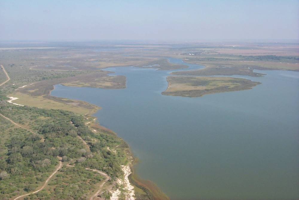
From the shallow bays to the inland marshes and grassy prairies, the coastal region provided a wide range of rich resources for Native peoples. Photo courtesy of Texas Historical Commission.

|
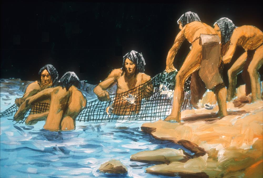
Native peoples harvest fish and other marine animals from a shallow bay. Many coastal groups spent fall and winter months—peak fishing seasons—in shoreline camps harboring several hundred people. Image courtesy of Texas Parks and Wildlife Department.
|
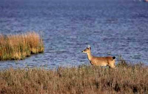
A deer pauses watchfully in thick marsh grasses near bay edge. These animals provided a concentration of resources—food, hides, and bone— for coastal Native peoples. Photo courtesy of the Texas Parks and Wildlife Department.
|
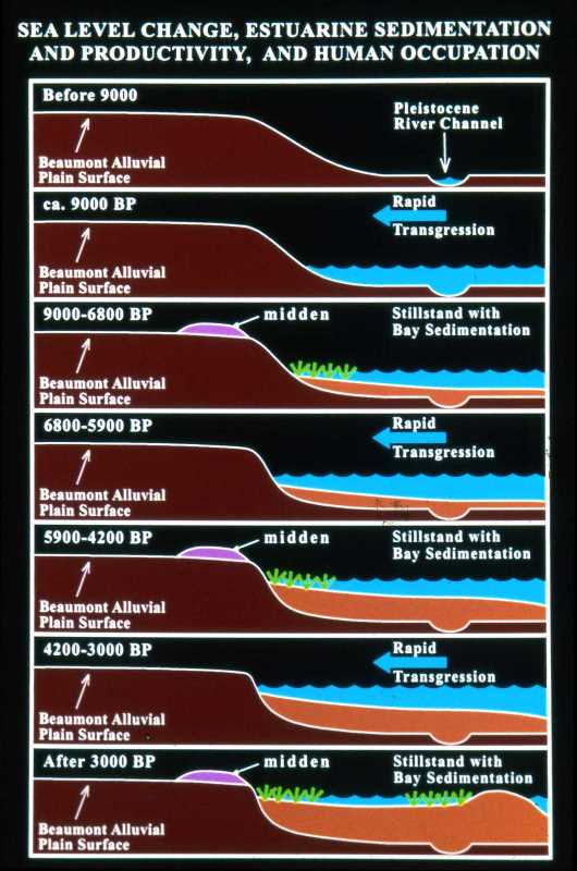
Estuary evolution sequence on the Gulf Coast during the Holocene period. Changes in sea level altered shoreline structure and Native subsistence patterns. Graphic by Robert A. Ricklis and Michael D. Blum.
|
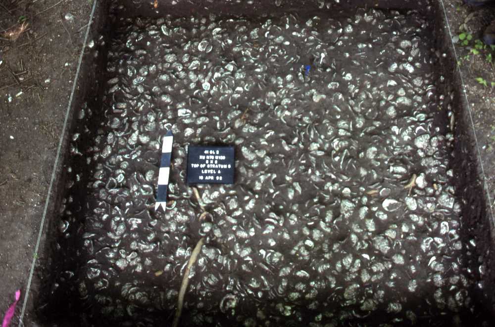
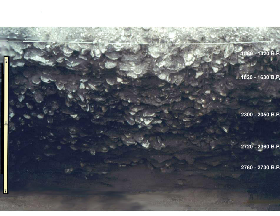
Oyster shell midden uncovered at the Guadalupe Bay site. These dense shell deposits are the discarded food remains from a large, Late Prehistoric fishing camp situated near the mouth of the San Antonio River. Photo by Richard Weinstein.
|
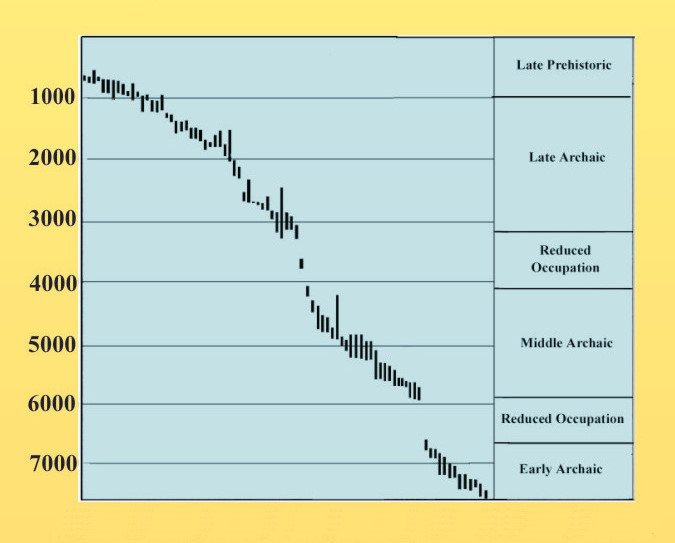
All radiocarbon dates from shell midden sites on Nueces and Corpus Christi Bays, suggesting discontinuities in shoreline occupation and resource use between 6,700-5,900 B.P. and 4,200-3100 B.P. Graphic by Robert Ricklis.
|

Prehistory sub-regions of the Texas coastal region. Graphic by Robert Ricklis.
|
Clovis point from McFaddin Beach, upper Texas coast. Thousands of artifacts have washed ashore from what was once the original site area, now submerged offshore in the Gulf. Although remains of all cultural periods have been found, the extraordinary numbers of Paleoindian artifacts and bones of now-extinct animals makes this site distinctive. Morris Weeks Collection; photo by Thomas R. Hester.
|
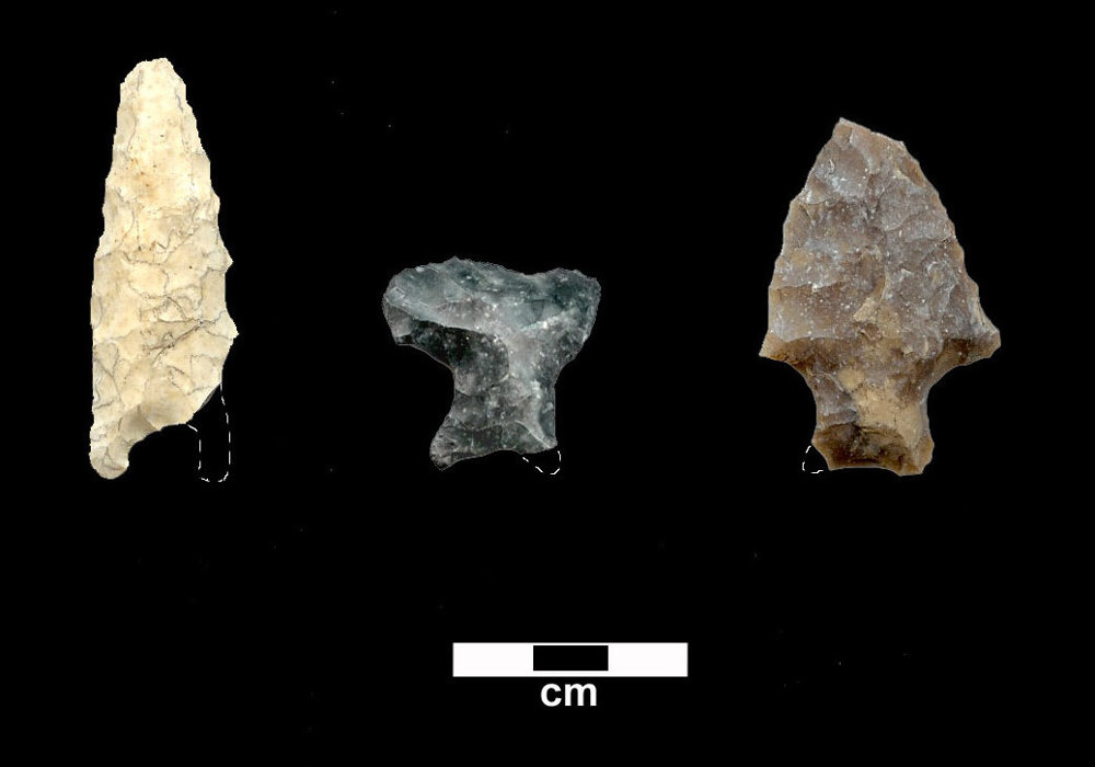
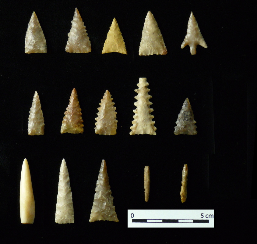
Examples of Early Archaic points of the Coastal region. Photo by Robert Ricklis.
|
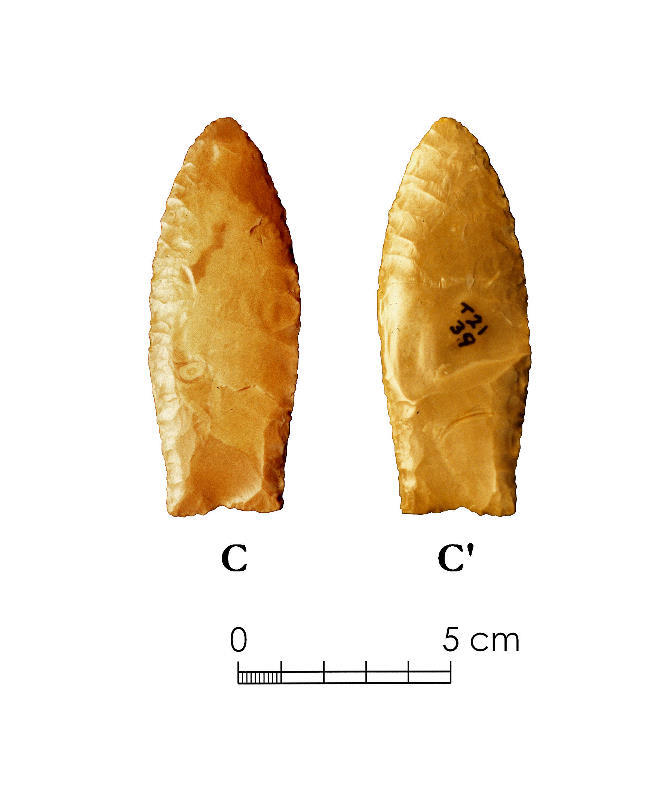
Early Archaic dart points from the Buckeye Knoll site. Artwork by Alexander Cox, from Ricklis, in press, 2007.
|

Profile of excavation at 41SP153 on north shore of Nueces Bay, showing three discrete shell strata within cumulic silty soil. Only a scant amount of chert debitage and a chert core were found in Stratum 3 representing the Early Archaic. Little is known about this period based on coastal sites. (Graphic by Robert Ricklis (in Perttula 2004: Fig.5.3).
|
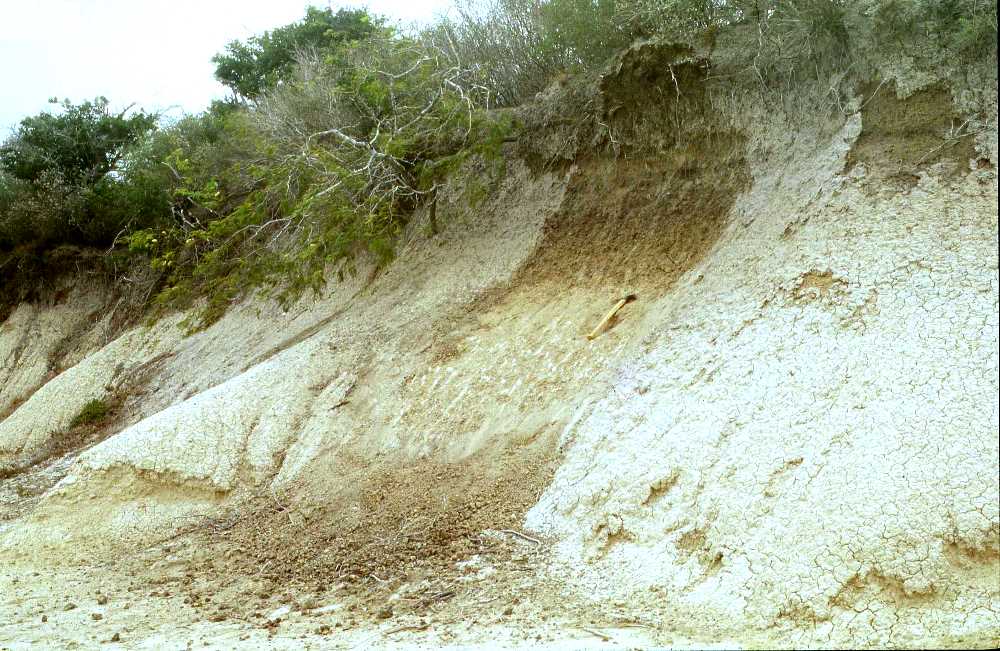
Clay dune overlooking Baffin Bay in the lower coast. Several oyster shell deposits dating to the Early and Middle Archaic indicate that the hypersalinity (over 60 parts per thousand) that came to characterize Baffin Bay in more recent times, conditions under which oysters and other mollusk cannot survive, did not yet exist. Photo by Robert Ricklis.
|
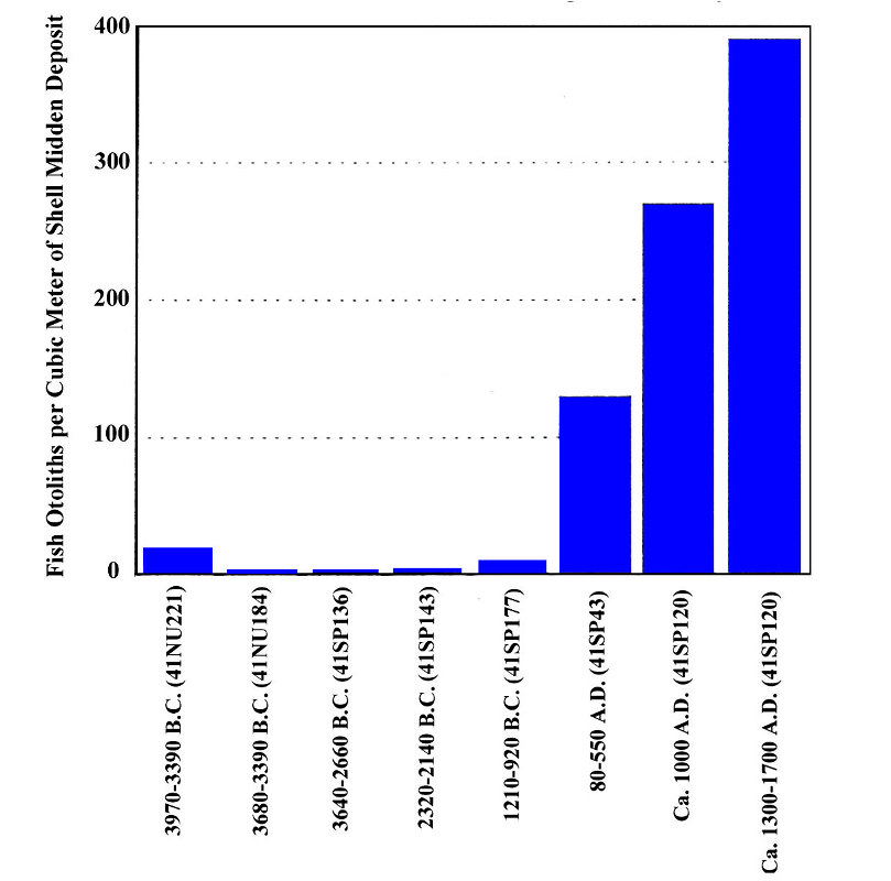
Density of fish otoliths in radiocarbon-dated middens of Middle Archaic through Late Prehistoric ages in Nueces and Corpus Christi Bay sites. Graphic by Robert Ricklis.
|
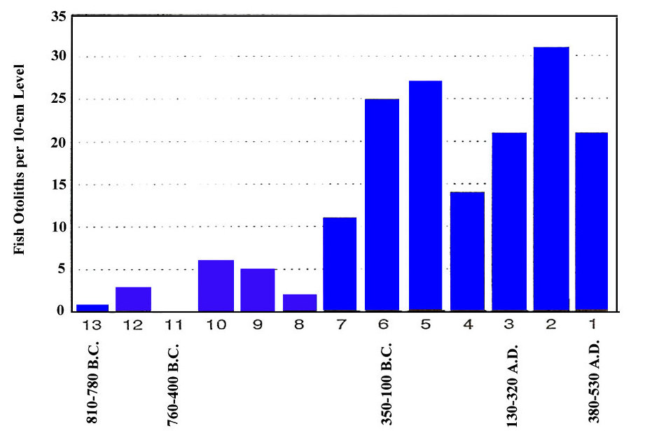
Quantities of fish otoliths by 10-centimeter levels in Late Archaic shell midden at the Mustang Lake site (41CL3), San Antonio Bay. Graphic by Robert Ricklis.
|
Late Archaic shell midden at the Mustang Lake Site (41CL3), with radiocarbon date ranges from samples denoted. Photo by Robert Ricklis.
|
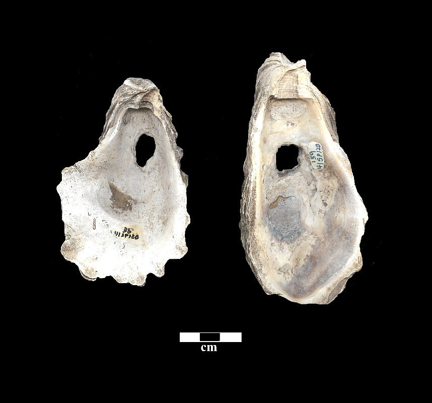
Perforated oyster shells (net weights) from Ingleside Cove site (41SP120). Shown are the interiors of lower valves. Photo by Robert Ricklis.
|
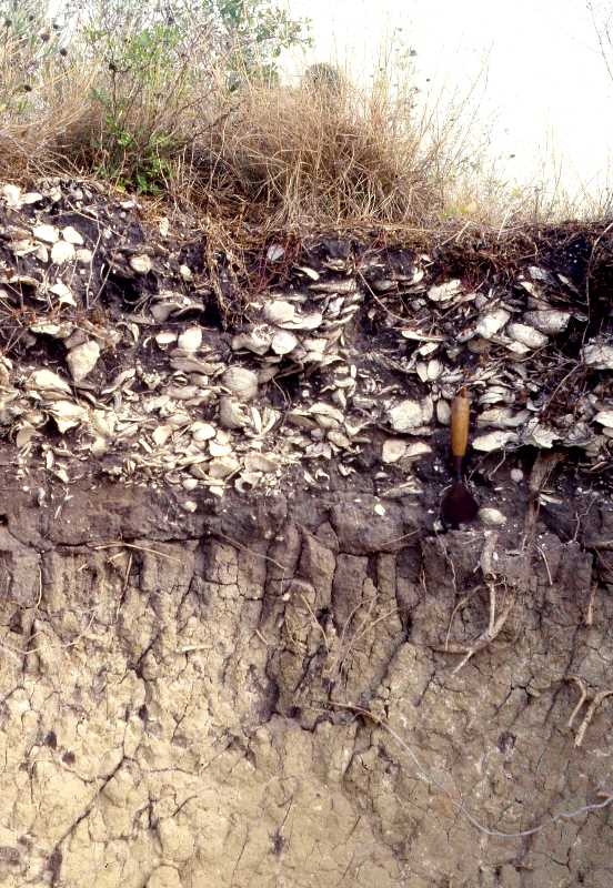
Late Archaic shell midden, eroding from side of bluff at the Kent Crane Site (41AS3). Photo by Robert Ricklis.
|
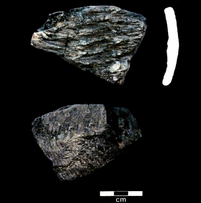
Asphaltum, a naturally occurring beach tar, was used
was used during the Late Archaic to line basketry, as seen here, where the preserved basket impressions are visible.
Photo by Robert Ricklis.
|
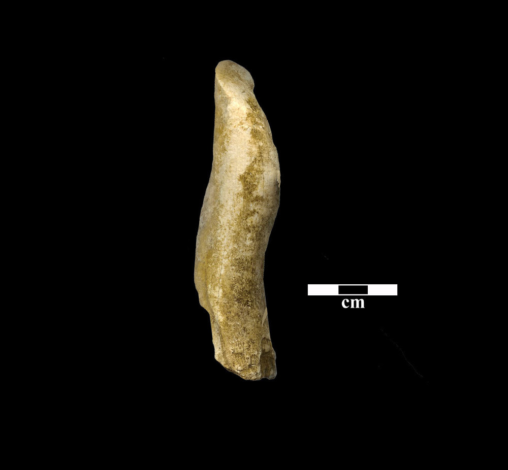
Whelk columella “gouge” from Late Archaic context at the Mustang Lake Site (41CL3). Note angled, ground facet at top end which creates the working edge. Photo by Robert Ricklis.
|
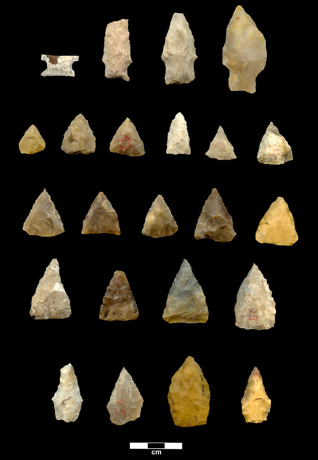
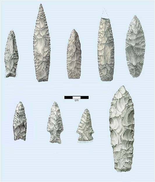
Stemmed and unstemmed dart points from the Late Archaic Tucker Site (41NU46). Types Ensor, Darl, Kent (2 specimens) are shown in top row; triangular Matamoros and Tortugas shown in middle rows; and unclassified pentagonal points in bottom row. Photo by Robert Ricklis. Enlarge to see additional specimens.
|
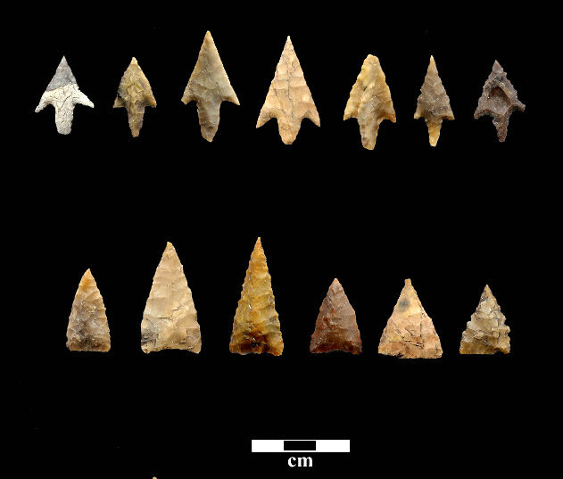
Arrow points from Ingleside Cove (41SP120). Points are from radiocarbon-dated, discrete strata. Top row, Perdiz arrow points associated with abundant Rockport pottery (i.e., Rockport Phase), after ca. A.D. 1250/1300; bottom row, Fresno arrow points., A.D. 1000-1250. Photo by Robert Ricklis.
|
Late Prehistoric cultural expressions Graphic from Ricklis and Weinstein 2005: Fig. 5.7.
|
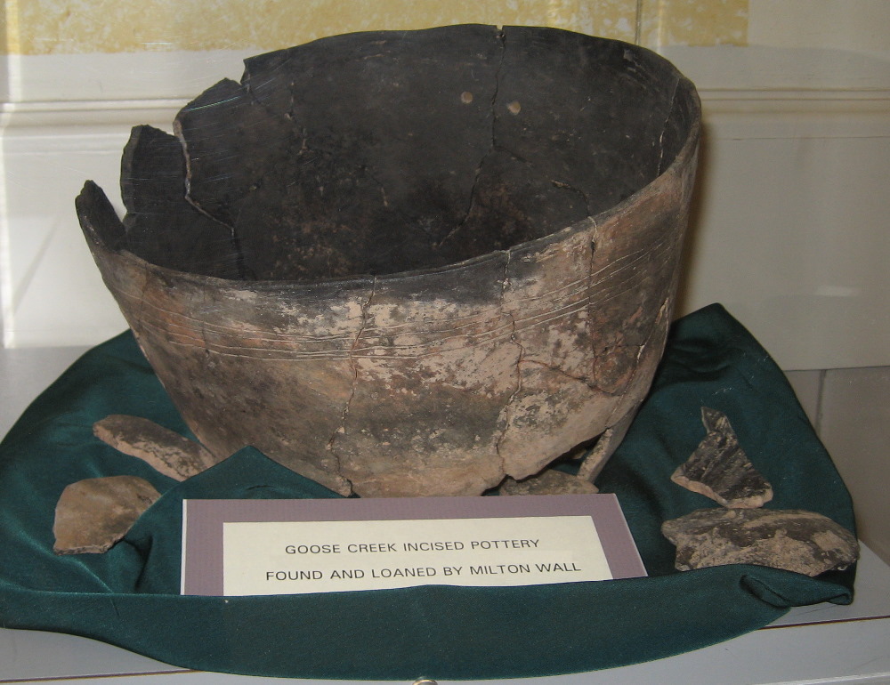
Goose Creek Incised vessel. Unlike earlier Tchefuncte pottery of the upper Texas coast, this pottery type marks a period of isolation from influences from cultures to the northeast. Vessel on display at Matagorda County Museum; photo by Susan Dial.
|
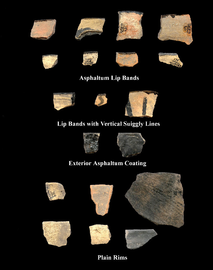
Varieties of Rockport pottery rimsherds from the Oak Mott Site (41AS92). This thin, sandy paste pottery was often coated or decorated with asphaltum. Photo by Robert Ricklis. Enlarge to see additional specimens |
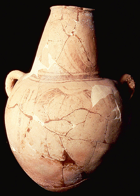
Water jar likely traded into the Rio Grande Delta area from the region of Tampico, Mexico. Note the offset looped handles to aid in strapping the vessel to one's back with rope or cordage. The jar was found in pieces and has been glued back together. Much of the painted design has faded due to exposure to the winds and sand before the vessel pieces were discovered. TARL Collections.
|
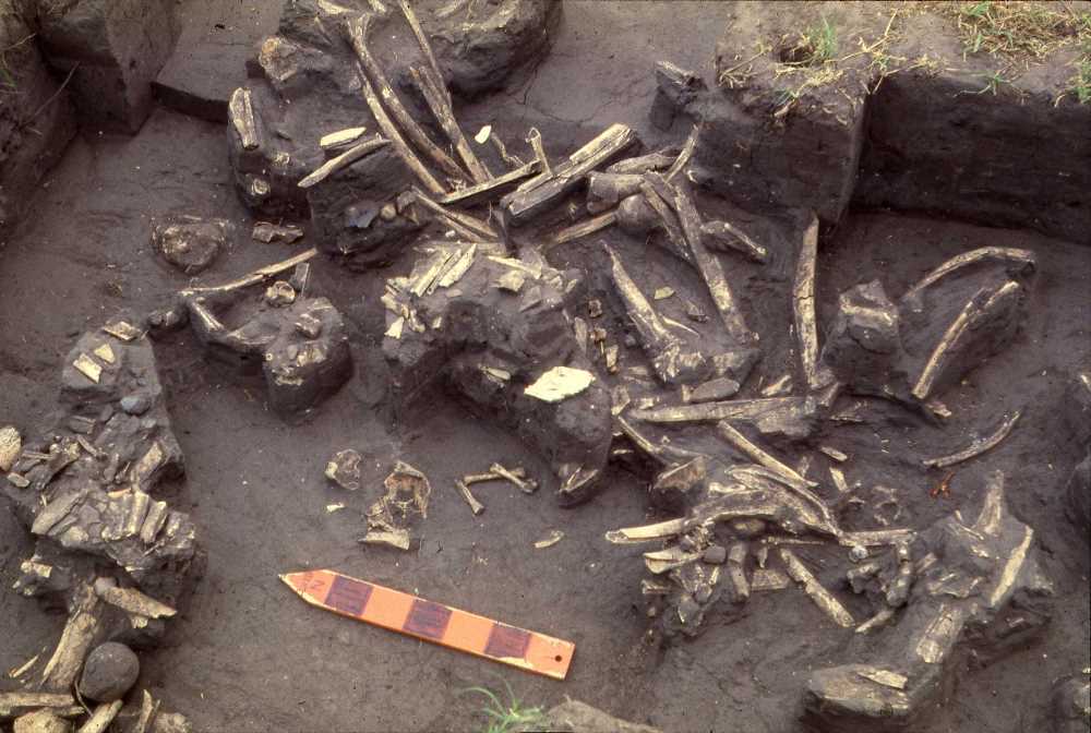
Bones of bison and deer uncovered at the Melon Site 41RF21. Pottery representing two distinct traditions—one coastal (Rockport Phase) and the other inland (Toyah Horizon)—suggests that coastal people shared this bison hunting camp with inland people who used an artifact assemblage typical of the Toyah Horizon. Photo by Robert Ricklis.
|
Examples of Late Prehistoric arrow points and drills (enlarge to see examples) from Nueces County surface collection. Photo by Frank Weir. |
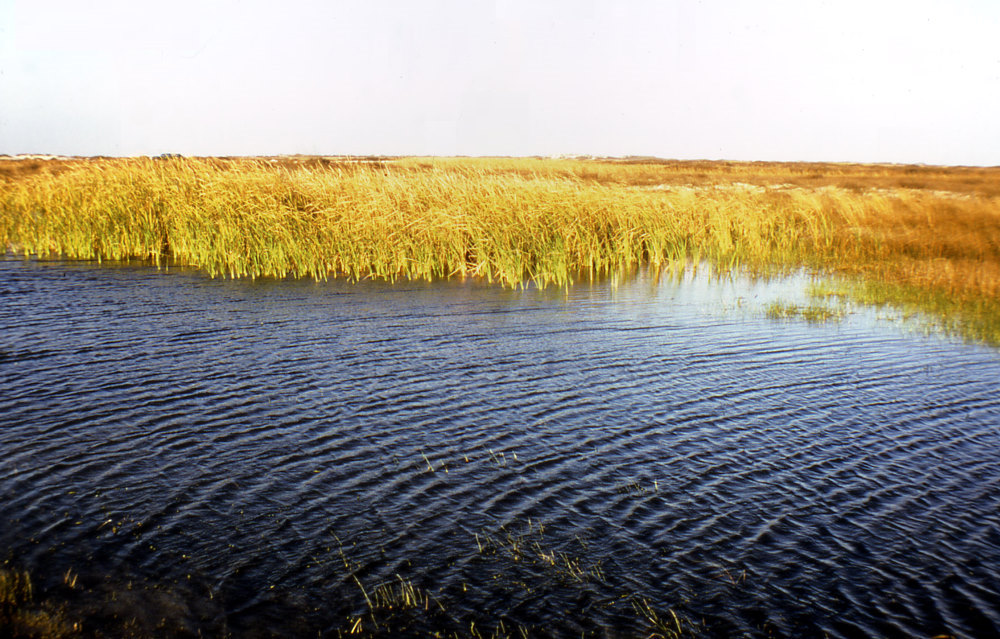
A grassy marsh inland from Padre Island. Photosynthesis in the shallow water combined with the plants produced nutrients to sustain a rich aquatic food chain, making the marshlands prime areas to hunt and gather food. TARL Archives.
|