Gaulding Site
The Gaulding site (41JF27) is a moderately large shell mound mainly dating to the Late Archaic period, located on Taylor Bayou approximately 15 miles south of Beaumont, Texas. Intermittent excavations there over a 30-year span yielded relatively few artifacts, but surprising data showing that three separate periods of midden accumulation, beginning about 4,000 years ago, seem to parallel a Late Holocene sequence of sea level fluctuations proposed by Florida geologist William F. Tanner. Simply put, “pulses” or intervals of slightly higher than modern sea level seem to have created favorable conditions for the growth of brackish-water rangia clams in Taylor Bayou. Native peoples took advantage of these periods of abundance and brought basketload after basketload of clams to the site. After shucking and eating the small clams, the shells were tossed aside and eventually amounted to a mounded accumulation up to five feet thick.
In 1965, the Texas Archeological Society’s fourth annual field school, under the direction of archeologist Dessamae Lorrain, placed excavations in several areas of the site. Numerous auger borings and profile trenches also were used to record the shell midden’s mass and stratification. In 1974, additional excavations were carried out in the near-surface ceramic deposits at the site under the supervision of Texas Archeological Steward Charles Bollich. Then, in 1995 and 1996 – thirty years after the original investigation – Bollich and archeologist Lawrence Aten dug several more soil borings around the site’s periphery, reopened one of the 1965 excavations to resample all cultural layers, and obtained two 4.5 inch diameter cores collectively penetrating the entire thickness of the site as a permanent record of the site’s strata.
In the re-opened 1965 excavation the mound profile was recorded in additional detail; bulk samples and radiocarbon samples were taken from all depositional layers. In the aggregate, this updated testing provided a much-improved understanding of the site’s place in the landscape, its periods and manner of use, and the potential for further investigation. The overall depositional structure of the site was identified and dated with a series of seven radiocarbon dates, and the formation of the site’s layers was examined as closely as possible with both outcrop descriptions and particle analysis of the bulk samples.
From the bulk samples a collection of terrestrial gastropods (land snails) suggested an evolving regional climate affecting the site, and geological evidence permitted an initial description of the place of the site in the regional landscape of Taylor Bayou drainage basin. Although artifacts were few, the ceramic, lithic, and other technologies were as closely examined as possible, yielding preliminary estimations of subsistence and other activities. And a single human burial was documented.
The landscape of southeast Texas is highly structured and probably has been so far back in time. First, there are the three coast-parallel zones starting with the extensive coastal seashore and marshes. Abutting the interior margin of the marshes is found the coastal prairies and landward of these are the interior woodlands. Perpendicularly crosscutting these coast-parallel zones are major rivers like the Sabine and Neches and their floodplains as well as large lakes such as Sabine and Calcasieu and smaller streams like Taylor Bayou where the Gaulding site was found. The significance of this is that Native Americans living there off the land had access to a wide range of subsistence and material resources. Gaulding was situated at an important environmental nexus.
The first of three periods of prehistoric use and accumulation at the Gaulding site occurred between 4000 and 3700 calibrated radiocarbon years ago (between about 2,000 and 1,700 B.C. After a hiatus the site was again used from around 2900 to 2700 calibrated radiocarbon years ago (about 900-700 B.C.). Finally, after another hiatus, the site was used sporadically from around 2000 to about 600 calibrated radiocarbon years ago (about A.D. 1 to 1400). Use of the site during the latter period was rare and much less refuse accumulated than during the earlier periods of site use.
Very few artifacts were found in deposits of the three periods of accumulation at Gaulding except for ceramics in the third and last period of site use. Although the ceramics collection is small, analysis of the clay characteristics yielded new information about technological distinctions between several of the named pottery varieties. Most notable is that the sand temper sources for O’Neal Plain variety Conway appear to be similar to and probably taken from point bar levee deposits in either the lower Neches or the lower Sabine rivers.
A particularly unexpected outcome after reviewing all of the landscape, geological, and archeological evidence of the site and its environs, was that its history and formation is most consistent with a model of Late Holocene small-scale sea level fluctuations that was initially proposed by Florida geologist W. F. Tanner. The Tanner model of lower and higher sea level episodes is still a preliminary concept, but it seems to account for the times of prehistoric occupation, the location, geometry and orientation of the shell deposits, and much of the material content of the archeological layers. For these reasons it has been used as the framework for describing the linkage between the culture history and the landscape history at the Gaulding site.
The earliest visible archeology in the Taylor Bayou basin is the initial shell deposit at the Gaulding site, dating to nearly 4000 calibrated years ago, at the onset of the Late Holocene and Late Archaic. During the warm, dry, Middle Holocene Altithermal event Taylor Bayou would have been an especially attractive environment at least for intermittent habitation. But any archeological evidence from that time or earlier will be difficult to locate. It either is submerged, now that the entrenched stream valley is filled to overflowing, or is buried under the extensive marsh deposits that blanket the entire basin.
Around 4000 years ago, however, the bayou was still entrenched in its narrow stream valley. Sea level controlled the level of water in the bayou, and was trending ever higher. But pulses of sea level, rising and falling over periods of hundreds of years, finally had reached high enough elevations (Tanner “A” episode) to enable larvae of the brackish-water clam Rangia cuneata to be flushed upstream into the middle reaches of the basin and there to establish populations. Rangia cuneata is a shellfish that is physiologically adapted to live in fresh or salt water, although it can only reproduce in low salinity habitats. At this time, Indian peoples began harvesting and processing the clams at new settlement locations overlooking the entrenched stream valley.
Judging from the land snail assemblages found at Gaulding, the climate at this time was still experiencing cold winters and warm, dry summers, but was ameliorating from the extreme temperatures and dryness prior to this time – known as the Altithermal. By about 3700 calibrated years ago, the area was noticeably more moist and warm with expanding riparian woodlands along the bayou and its tributaries.
During the time of this early shell-accumulating occupation at Gaulding, the peoples living there must have used tools and other equipment that were largely made from perishable materials; very little technology from that time was preserved in the site. The presence of oysters that probably were collected several kilometers downstream suggests that watercraft were in use at this early date. Nothing is known of the plant foods they may have gathered and used but in addition to the clams, they killed or scavenged relatively few vertebrate animals. Assuming the evidence is not biased by preservation problems, these included birds, small animals such as turtles and a moderate amount of fish. The largest animals taken were occasional deer. Fishing may have been done with nets as the technology included some perforated clam shells that are believed to be net weights. Little is known of the manner in which the habitation site was organized during the early occupation, but the several layers formed during this time signify different origins. The earliest layer penetrated by the excavation may have been a refuse dump (midden). The contents of the succeeding levels suggest they formed as domestic activity areas.
Around 3700 calibrated years ago use of this campsite halted. From this time onward only a very little sediment accumulated at the top of the old shell deposit. In this sediment, soil-forming processes began and continued for about seven centuries. During part of this time interval, a lower than normal sea level period occurred (Tanner “B” episode) that must have ensured that the hydrology of Taylor Bayou was exclusively fresh water. No brackish water clam populations could become established and evidently no archeological shell sites formed. People may have continued using the basin though, exploiting the nearby prairies and the freshwater riparian environments, but leaving archeological residues that are extremely difficult to detect.
Around 2900 calibrated years ago, another high sea level pulse (Tanner “C” episode) may have occurred, raising the level of Taylor Bayou again for three or four hundred years. As before, this must have enabled larvae of the brackish-water clam, Rangia cuneata, to be flushed upstream establishing new populations because Indian peoples again began to harvest them. Ultimately they formed a substantial new accumulation of clam shells precisely on top of the old campsite’s shell debris that had been abandoned some eight centuries before. Even though sea level was higher than normal at this time, there are no indications that water overtopped the upper edges of the entrenched stream valley, at least not in the middle basin, as there is no sediment accumulation mixed into the campsite shell debris at Gaulding.
The climate at this time was largely a continuation of the relatively warm and moist conditions that were beginning to set in near the end of the earlier shell site’s use. This second period of campsite use continued intermittently over a span of perhaps two centuries. By the end of that time, the climate was changing to somewhat drier conditions with grasslands again expanding on the upland prairies surrounding Taylor Bayou.
During the time of this middle period of occupation at Gaulding, the people living there seemed to have changed their tools very little from those used nearly a thousand years before. Oysters continued to be collected from downstream near Sabine Lake probably indicating continued watercraft use. Bone tools and chipped stone tools continued to be extremely rare, and the vertebrate animals they obtained were not greatly different from those preserved from the previous campsite dating hundreds of years earlier. Again, little can be said about the organization of their campsites but what is seen seems to be all debris formed in domestic activity areas.
Around 2700 calibrated years ago, shell harvesting and accumulation at this second campsite halted once again. This may or may not have been related to the onset of the next falling sea level period (Sanibel I episode), but the latter almost certainly eliminated any possibility of periodically replenishing the Rangia clam beds. Although use of the basin may have continued, it did not involve shellfish harvesting and there is no known archeological evidence until several centuries later. Sometime during the period of 2000 to 2500 calibrated years ago, an apparently brief use of the surface of the Gaulding site shell ridge occurred by people who left a few fragments of early ceramic Tchefuncte culture pottery. This was during the previously mentioned low sea level period and although there are some shells in the deposit it cannot be said whether they were in association with the pottery. One advantage of pottery-using cultures is that there is a lot more artifact debris that can leave a habitation signature. This small amount of Tchefuncte pottery may be an indication of some non-shell fishing use of the Taylor Bayou basin.
Around 2000 calibrated years ago, the highest sea level pulse (Wulfert episode) began lasting for about five centuries. The water level evidently spilled out of the entrenched stream valley and rose up at times to a level about 1.5 meters above today’s sea level. This event drowned the entire lower and middle drainage basin. It relocated the shoreline landward for substantial distances in some areas, displacing possible locations for habitation sites to above the 5-foot (1.5 m) contour line. Marsh deposits formed throughout the middle and lower basin, and the entire ponded area began to be filled with sediment blanketing drowned archeological sites and geomorphic features. Although some shell-bearing archeological sites attributable to this period have been found at the higher elevation they have not been investigated. Along with small quantities of Rangia shell, indicating some occasional habitation, the upper deposits at Gaulding include potsherds that could easily be attributed to the time period between the respective ages of Tchefuncte earthenware and Caddoan earthenware found in the same deposits.
Reading the land snails again, the climate from this time onward was approximately the moist precipitation and moderate seasonal temperatures that characterize the present day. However, the abundance of clam beds declined sharply from this time on and archeological shell sites, while they are not unknown, also are not numerous. This reduction, but not elimination, of clam populations during a time of higher sea level may have been a combined function of shoaling of the bayou channel and increased freshwater flow resulting from the moist climate.
This highest sea level event came to an end around 1500 calibrated years ago with the onset of another low sea level period (Buck Key episode) that, in turn, ended with the final, more modest, high sea level period (LaCosta episode) from 500 to 1000 calibrated years ago. One consequence of the 1500 to 2000 years ago high sea level period may have been that it lifted the bayous out of their long-time channel which then may have become filled with sediment. When sea level again fell (Sanibel II episode), the bayou channels apparently became established in slightly different locations, because the orientations of numerous sites no longer conform to the bayou channels of the present. Although large Rangia cuneata beds were no longer being established, small ones occurred from time to time, possibly during the 500 to 1000 year ago sea level rise.
There was a final prehistoric use of the Gaulding shell ridge around 600 to 700 years ago. Small quantities of shellfish were harvested and processed here, although another contemporaneous site located not far away had a more substantial shell accumulation. The climate at this time continued more or less like that of the present. The technology preserved at the site from this time is somewhat elaborated over that used by the Late Archaic peoples of more than a thousand years earlier. By this time the toolkit, though still limited, included some different projectile points and other chipped stone tools, bone awls, shell ornaments, and perforated clam shell net weights. The quantities of vertebrate animals had increased significantly and had begun to proportionally displace shellfish. By the time of this final prehistoric use of the site, it was apparently being visited during the spring months, and possibly during the winter as well. Deer, alligator, and fish had become the major components of the vertebrate animal diet. The presence of green sea turtle bones in the site tells a clear story of canoeing downstream as far as the estuarine lower Sabine Lake to collect oysters, and on to the Gulf beaches to collect sea shells from the beaches, and, in at least that one case, a sea turtle. It still is not possible to tell much about the organization of the campsite at this time, but the contents of the sediment suggest that the particular location that was bulk-sampled in 1995-96 may have been a midden and latrine area. During or after this time, a middle-aged adult woman visiting this area died and was interred on the Gaulding shell ridge.
Gaulding and other sites in the Taylor Bayou drainage basin are important localities for further archeological and geoarcheological investigations. Although local archeological sites contain precious few artifacts that would interest collectors, the broken bits of pottery, animal bone, and the environmental data described above show the drainage basin’s scientific potential. Although the basin has far fewer sites than the nearby Neches and Sabine River floodplains, it is less susceptible to overbank flooding, sedimentation, and erosion.
Taylor Bayou is an environment in which preservation of subtle environmental perturbations – especially those due to sea level – may be more likely. Testing many of the preliminary environmental history suggestions developed there can be done through more detailed site survey in areas of the basin where higher elevation settlement is implied by the Tanner sea level model. The Gaulding site is interesting also for its extensive and relatively easy to distinguish deposits of late Middle Archaic or early Late Archaic age. This is a site from which much more could be learned amid the mud, mosquitoes, and endless clam shells.
Contributed by Lawrence E. Aten and Charles N. Bollich.
Sources
Aten, Lawrence E. and Charles N. Bollich
2002 Late Holocene Settlement in the Taylor Bayou Drainage Basin: Test Excavations at the Gaulding Site (41JF27), Jefferson County, Texas. Studies in Archeology 40, Texas Archeological Research Laboratory, The University of Texas at Austin, and Special Publication No. 4, Texas Archeological Society.
Tanner, William F.
1991 The “Gulf of Mexico” Late Holocene Sea Level Curve and River Delta History. Gulf Coast Association of Geological Societies Transactions 41:583-589.
![]()
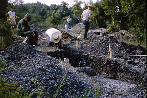
View of the 1965 excavations in progress. Shell middens are inherently messy, labor-intensive places to dig. Participants of the June 1965 field school at Gaulding recall daily encounters with mud, mosquitoes, and endless clam shells. TARL Archives.

|
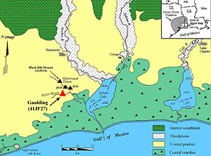
Map showing approximate location of the Gaulding site and the highly structured environment of the area. Three parallel coastal ecological zones (coastal marshes, coastal prairies, and interior woodlands) are crosscut by major rivers like the Sabine and Neches and their floodplains, large natural lakes such as Sabine and Calcasieu, and smaller streams like Taylor Bayou where the Gaulding site was found. Adapted from Aten and Bollich 2002.
|
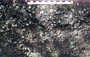
Close-up view of profile through the dense shell midden with its many tons of rangia shells. Tree-dappled lighting obscures the stratigraphy, but with careful study and analysis, three major periods of accumulation were detected. Photo taken in 1995 of the reopened west wall of excavation unit B-1; TARL Archives.
|
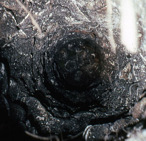
View down one of the soil bore holes dug through an intact section of the Gaulding shell midden in 1995. The four-inch auger bucket samples provided stratigraphic information and they are archived as a permanent record of the site. Future researchers may find these useful for dating and soil testing. TARL Archives.
|
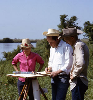
Field director Dessame Lorrain confirming with Curtis Tunnel (center) during the 1965 Texas Archeological Society Field School. TARL Archives.
|
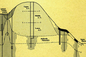
Simplified and vertically exaggerated (20X) schematic cross-section illustrating the Gaulding site stratigraphy based on excavation and soil boring data.
Enlarge to see details and full graphic. |
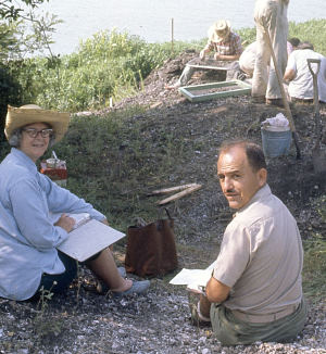
Doris Olds and Charles Bollich look up from taking field notes at the 1965 Texas Archeological Society Field School. TARL Archives.
|
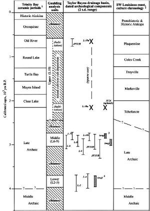
Cultural chronologies bracketing the Sabine Lake with radiocarbon dates from sites in the Taylor Bayou Drainage Basin. Aten and Bollich 2002, Figure 9.
|
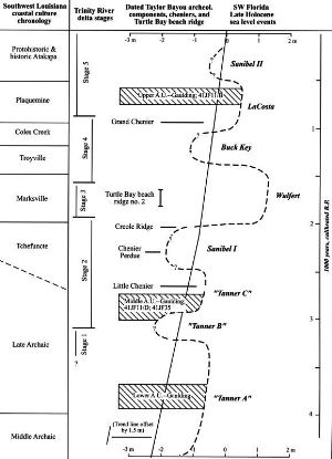
Tanner Gulf of Mexico Late Holocene sea level curve relative to archeological and cultural features from Taylor Bayou, Galveston Bay, and southwest Louisiana. Aten and Bollich 2002, Figure 30.
|