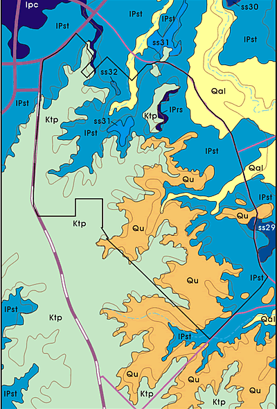
Geologic map of the Camp
Bowie area. The numerous sources of sandstone and limestone in the major
geological formations within Camp Bowie made it an ideal location for constructing
earth ovens, as well as obtaining chert for making stone tools. Holocene
age (Qal) floodplain deposits, containing a variety of gravels, are associated
with the secondary streams within the camp, as well as the Pecan Bayou floodplain
just to the northeast of the project area. The Qu designation denotes Holocene
or Pleistocene surficial deposits, which can exceed 50 feet in thickness
in some areas. These are primarily limestone, with cherts and some quartz
present. The Travis Peak Formation (Ktp), is Cretaceous in age, and contains
a variety of materials including conglomerate, sandstone, and limestone.
Cherts and quartz are present in the lower part of the formation. Finally,
the Strawn Group (IPst) is a Pennsylvanian-age deposit containing sandstone,
shale, mudstone, conglomerate, siltstone, and limestone. Several cases of
sandstone deposits (e.g., ss32) are present as well. Map adapted from V.
E. Barnes, Geologic Atlas of Texas, Brownwood Sheet, UT Bureau of Economic
Geology 1976.